 |
|
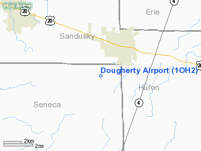
Location & QuickFacts
| FAA Information Effective: | 2008-09-25 |
| Airport Identifier: | 1OH2 |
| Airport Status: | Operational |
| Longitude/Latitude: | 082-51-58.6000W/41-14-38.4000N
-82.866278/41.244000 (Estimated) |
| Elevation: | 807 ft / 245.97 m () |
| Land: | 0 acres |
| From nearest city: | 3 nautical miles S of Bellevue, OH |
| Location: | Huron County, OH |
| Magnetic Variation: | () |
Owner & Manager
| Ownership: | Privately owned |
| Owner: | Marion L. Dougherty |
| Address: | 6121 Route 20 East
Bellevue, OH 44811 |
| Phone number: | 419-483-3569 |
| Manager: | Marion L. Dougherty |
| Address: | 6121 Route 20 East
Bellevue, OH 44811 |
| Phone number: | 419-483-3569 |
Airport Operations and Facilities
| Airport Use: | Private |
| Wind indicator: | Yes |
| Segmented Circle: | No |
| Control Tower: | No |
| Sectional chart: | Detroit |
| Region: | AGL - Great Lakes |
| Boundary ARTCC: | ZOB - Cleveland |
| Tie-in FSS: | CLE - Cleveland |
| FSS Toll Free: | 1-800-WX-BRIEF |
Runway Information
Runway 10/28
| Dimension: | 3000 x 80 ft / 914.4 x 24.4 m |
| Surface: | TURF, |
| |
Runway 10 |
Runway 28 |
| Traffic Pattern: | Left | Left |
| Displaced threshold: | 0.00 ft | 700.00 ft
DSPLCD THLD MKD WITH METAL DRUMS PAINTED YELLOW. |
| Obstruction: | | 60 ft pline, 700.0 ft from runway |
|
Radio Navigation Aids
| ID |
Type |
Name |
Ch |
Freq |
Var |
Dist |
| PCW | NDB | Port Clinton | | 423.00 | 06W | 16.5 nm |
| TII | NDB | Tiffin | | 269.00 | 05W | 17.8 nm |
| FZI | NDB | Fostoria | | 379.00 | 05W | 24.2 nm |
| AAU | NDB | Ashland | | 329.00 | 07W | 32.5 nm |
| PT | NDB | Pelee Island | | 283.00 | 05W | 33.4 nm |
| MF | NDB | Manns | | 372.00 | 06W | 34.5 nm |
| BNR | NDB | Benton Ridge | | 334.00 | 05W | 38.7 nm |
| MNN | NDB | Marion | | 201.00 | 05W | 38.8 nm |
| CL | NDB | Harri | | 344.00 | 07W | 41.1 nm |
| TOL | TACAN | Toledo | 072X | | 05W | 47.0 nm |
| MAH | VOR | Marathon | | 114.90 | 05W | 38.7 nm |
| BUD | VOR | Buckeye | | 109.80 | 05W | 38.8 nm |
| SKY | VOR/DME | Sandusky | 029X | 109.20 | 04W | 14.9 nm |
| DJB | VOR/DME | Dryer | 083X | 113.60 | 05W | 32.5 nm |
| VWV | VOR/DME | Waterville | 078X | 113.10 | 02W | 37.0 nm |
| MFD | VORTAC | Mansfield | 025X | 108.80 | 03W | 25.8 nm |
| FDY | VORTAC | Findlay | 019X | 108.20 | 02W | 43.9 nm |
| CLE | VOT | Cleveland | | 110.40 | | 47.0 nm |
Remarks
- PRVDD CLEAR 20:1` APCHS & CLEAR OBSTL FREE ZONE.
Images and information placed above are from
http://www.airport-data.com/airport/1OH2/
We thank them for the data!
| General Info
|
| Country |
United States
|
| State |
OHIO
|
| FAA ID |
1OH2
|
| Latitude |
40-28-30.190N
|
| Longitude |
083-40-34.753W
|
| Elevation |
1260 feet
|
| Near City |
RUSHSYLVANIA
|
We don't guarantee the information is fresh and accurate. The data may
be wrong or outdated.
For more up-to-date information please refer to other sources.
|
|


