 |
|
Location & QuickFacts
| FAA Information Effective: | 2008-09-25 |
| Airport Identifier: | 55OH |
| Airport Status: | Operational |
| Longitude/Latitude: | 081-57-02.5070W/41-28-33.1560N
-81.950696/41.475877 (Estimated) |
| Elevation: | 650 ft / 198.12 m (Estimated) |
| Land: | 2 acres |
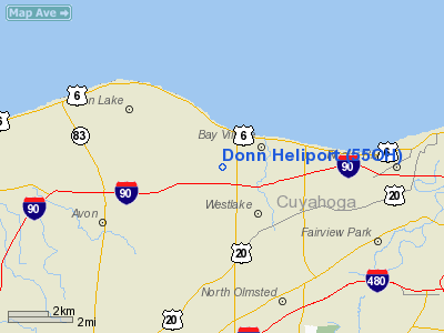
| From nearest city: | 0 nautical miles N of Westlake, OH |
| Location: | Cuyahoga County, OH |
| Magnetic Variation: | 06W (1985) |
Owner & Manager
| Ownership: | Privately owned |
| Owner: | Don Brown |
| Address: | 5605 W Lake Road
Vermilion, OH 44089 |
| Phone number: | 216-967-7600 |
| Manager: | Don Brown |
| Address: | 5605 W Lake Rd
Vermilion, OH 44089 |
| Phone number: | 216-967-1805 |
Airport Operations and Facilities
| Airport Use: | Private |
| Wind indicator: | Yes |
| Segmented Circle: | No |
| Control Tower: | No |
| Landing fee charge: | No |
| Sectional chart: | Detroit |
| Region: | AGL - Great Lakes |
| Boundary ARTCC: | ZOB - Cleveland |
| Tie-in FSS: | CLE - Cleveland |
| FSS on Airport: | No |
| FSS Toll Free: | 1-800-WX-BRIEF |
Airport Services
Runway Information
Helipad H1
| Dimension: | 100 x 100 ft / 30.5 x 30.5 m |
| Surface: | CONC-TURF, Good Condition |
| |
Runway H1 |
Runway |
| Traffic Pattern: | Left | Left |
| VASI: | privately owned | |
|
Radio Navigation Aids
| ID |
Type |
Name |
Ch |
Freq |
Var |
Dist |
| CL | NDB | Harri | | 344.00 | 07W | 8.3 nm |
| EZE | NDB | Engel | | 226.00 | 07W | 10.3 nm |
| BKL | NDB | Burke Lakefront | | 416.00 | 07W | 13.3 nm |
| LQL | NDB | Lakeland | | 263.00 | 08W | 28.5 nm |
| AAU | NDB | Ashland | | 329.00 | 07W | 33.7 nm |
| AK | NDB | Akron | | 362.00 | 07W | 35.3 nm |
| PT | NDB | Pelee Island | | 283.00 | 05W | 37.1 nm |
| PCW | NDB | Port Clinton | | 423.00 | 06W | 41.4 nm |
| MF | NDB | Manns | | 372.00 | 06W | 48.2 nm |
| DJB | VOR/DME | Dryer | 083X | 113.60 | 05W | 11.9 nm |
| LNN | VOR/DME | Lost Nation | 039X | 110.20 | 08W | 28.2 nm |
| SKY | VOR/DME | Sandusky | 029X | 109.20 | 04W | 31.8 nm |
| CXR | VOR/DME | Chardon | 074X | 112.70 | 05W | 35.5 nm |
| ACO | VOR/DME | Akron | 091X | 114.40 | 04W | 40.4 nm |
| MFD | VORTAC | Mansfield | 025X | 108.80 | 03W | 46.6 nm |
| CLE | VOT | Cleveland | | 110.40 | | 6.0 nm |
| CAK | VOT | Akron/canton Regional | | 110.60 | | 40.8 nm |
Remarks
- APCH/DEP RTE HELI OPNS CONDUCTED IN AN AREA 350-010 & 150-280 DEG CLKWS USING PAD AS THE CNTR OF A COMPASS ROSE. TKOF/LNDG AREA APROPLY MKD; NON-OBSTG WIND INDCTR MAINTD ADJ TO TKOF/LNDG AREA; 30'TREES 130'S OF PAD ARE REMOVED.
Images and information placed above are from
http://www.airport-data.com/airport/55OH/
We thank them for the data!
| General Info
|
| Country |
United States
|
| State |
OHIO
|
| FAA ID |
55OH
|
| Latitude |
41-28-33.156N
|
| Longitude |
081-57-02.507W
|
| Elevation |
650 feet
|
| Near City |
WESTLAKE
|
We don't guarantee the information is fresh and accurate. The data may
be wrong or outdated.
For more up-to-date information please refer to other sources.
|
|


