 |
|
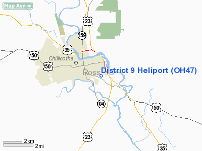
Location & QuickFacts
| FAA Information Effective: | 2008-09-25 |
| Airport Identifier: | OH47 |
| Airport Status: | Operational |
| Longitude/Latitude: | 082-57-07.1420W/39-19-27.2320N
-82.951984/39.324231 (Estimated) |
| Elevation: | 619 ft / 188.67 m (Estimated) |
| Land: | 2 acres |
| From nearest city: | 2 nautical miles SE of Chillicothe, OH |
| Location: | Ross County, OH |
| Magnetic Variation: | 05W (1985) |
Owner & Manager
| Ownership: | Privately owned |
| Owner: | Ohio Dept Of Transportation |
| Address: | 650 Eastern Ave.
Chillicothe, OH 45601 |
| Manager: | Jack O. Snyder |
| Address: | 301 E Water St
Chillicothe, OH 45601 |
| Phone number: | 614-773-2691
HOME PHONE 614-775-4570. |
Airport Operations and Facilities
| Airport Use: | Private |
| Wind indicator: | Yes |
| Segmented Circle: | No |
| Control Tower: | No |
| Landing fee charge: | No |
| Sectional chart: | Cincinnati |
| Region: | AGL - Great Lakes |
| Boundary ARTCC: | ZID - Indianapolis |
| Tie-in FSS: | DAY - Dayton |
| FSS on Airport: | No |
| FSS Toll Free: | 1-800-WX-BRIEF |
Runway Information
Helipad H1
| Dimension: | 75 x 75 ft / 22.9 x 22.9 m |
| Surface: | ASPH-CONC, |
| |
Runway H1 |
Runway |
| Traffic Pattern: | Left | Left |
|
Radio Navigation Aids
| ID |
Type |
Name |
Ch |
Freq |
Var |
Dist |
| AJY | FAN MARKER | Ashland | | | 03W | 46.7 nm |
| RZT | NDB | Ross County | | 236.00 | 05W | 7.7 nm |
| EOP | NDB | Waverly | | 385.00 | 06W | 9.5 nm |
| CYO | NDB | Circleville | | 366.00 | 05W | 12.0 nm |
| CSS | NDB | Court House | | 414.00 | 05W | 26.3 nm |
| HOC | NDB | Hillsboro | | 278.00 | 05W | 28.8 nm |
| PZO | NDB | Peebles | | 329.00 | 02W | 29.9 nm |
| BU | NDB | Boutn | | 230.00 | 05W | 32.0 nm |
| PMH | NDB | Portsmouth | | 373.00 | 04W | 33.0 nm |
| IL | NDB | Airbo | | 407.00 | 04W | 37.8 nm |
| UGS | NDB | University | | 250.00 | 06W | 38.6 nm |
| AMT | NDB | West Union | | 359.00 | 04W | 40.1 nm |
| CM | NDB | Sumie | | 391.00 | 05W | 40.8 nm |
| CHC | NDB | Grens | | 272.00 | 04W | 41.4 nm |
| HW | NDB | Cubla | | 299.00 | 04W | 43.0 nm |
| UYF | NDB | London | | 263.00 | 06W | 43.7 nm |
| DKG | NDB | Don Scott | | 348.00 | 05W | 45.8 nm |
| OS | NDB | Fuler | | 515.00 | 05W | 46.5 nm |
| GAS | NDB | Gallipolis | | 420.00 | 07W | 47.2 nm |
| HEH | NDB | Newark | | 524.00 | 06W | 47.8 nm |
| LCK | TACAN | Rickenbacker | 069X | | 05W | 29.1 nm |
| XUB | VOR | Yellow Bud | | 112.50 | 05W | 12.2 nm |
| MXQ | VOR/DME | Midwest | 076X | 112.90 | 04W | 40.0 nm |
| YRK | VORTAC | York | 075X | 112.80 | 05W | 40.9 nm |
| CMH | VOT | Port Columbus | | 111.00 | | 40.4 nm |
Remarks
- PROVD PERM CLRD OF OBST INCL TRUCKS & EQUIP SHOULD BE RMVD TO PROVIDE 8:1 CLNC; INGRESS/EGRESS S ON 180 DEG.
Images and information placed above are from
http://www.airport-data.com/airport/OH47/
We thank them for the data!
| General Info
|
| Country |
United States
|
| State |
OHIO
|
| FAA ID |
OH47
|
| Latitude |
39-19-27.232N
|
| Longitude |
082-57-07.142W
|
| Elevation |
619 feet
|
| Near City |
CHILLICOTHE
|
We don't guarantee the information is fresh and accurate. The data may
be wrong or outdated.
For more up-to-date information please refer to other sources.
|
|


