 |
|
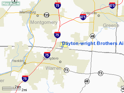
Dayton-wright Brothers Airport |
Coordinates: 39°35′20″N 084°13′30″W / 39.58889°N 84.225°W / 39.58889; -84.225
| Dayton-Wright Brothers Airport |
| IATA: MGY – ICAO: KMGY – FAA LID: MGY |
| Summary |
| Airport type |
Public |
| Owner |
City of Dayton |
| Serves |
Dayton, Ohio |
| Elevation AMSL |
957 ft / 292 m |
| Runways |
| Direction |
Length |
Surface |
| ft |
m |
| 2/20 |
5,000 |
1,524 |
Asphalt |
| Statistics (2005) |
| Aircraft operations |
89,045 |
| Based aircraft |
90 |
| Source: Federal Aviation Administration |
Dayton-Wright Brothers Airport (IATA: MGY, ICAO: KMGY, FAA LID: MGY) is a public airport located 10 miles (16 km) south of the central business district of Dayton, a city in Montgomery County, Ohio, United States. It is owned by the City of Dayton. The airport's identifying code, MGY, is a reference to its earlier name of Montgomery County Airport. The Airport is owned and operated by the City of Dayton and serves as the reliever airport for Dayton International Airport. Facilities and aircraft
Dayton-Wright Brothers Airport covers an area of 541 acres (219 ha) which contains one asphalt paved runway (2/20) measuring 5,000 x 100 ft (1,524 x 30 m). The airport has instrument landing facilities, but does not have a control tower.
For the 12-month period ending February 11, 2005, the airport had 89,045 aircraft operations, an average of 243 per day: 93% general aviation, 7% air taxi and <1% military. There are 90 aircraft based at this airport: 71% single engine, 26% multi-engine, 2% helicopter and 1% jet.
The airport facilities also include a runway equipped with a partial precision approach consisting of a localizer (LOC), approach lighting system (MALS), runway lighting (MIRL) and a visual approach slope indicator (VASI), 68 T-hangars, 6 conventional hangars, 5,000 sq ft (460 m). maintenance facility and 9,600 sq ft (890 m) administration building.
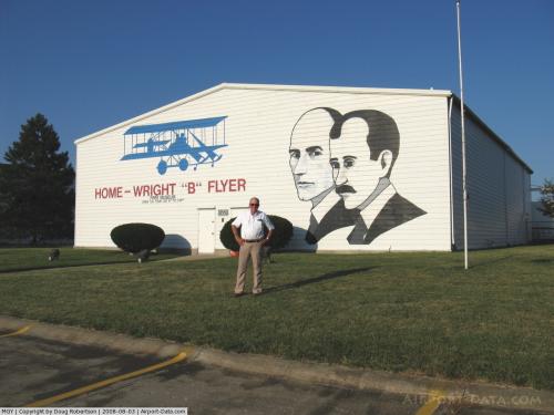
Historic replicas
On the airport grounds is a replica of the Wright Brothers' Huffman Prairie hangar, containing a museum and replica Wright B Flyer. The museum is open to the public during limited hours.
The above content comes from Wikipedia and is published under free licenses – click here to read more.
 |
(Click on the photo to enlarge) |
Location & QuickFacts
| FAA Information Effective: | 2008-09-25 |
| Airport Identifier: | MGY |
| Airport Status: | Operational |
| Longitude/Latitude: | 084-13-29.5000W/39-35-20.3000N
-84.224861/39.588972 (Estimated) |
| Elevation: | 957 ft / 291.69 m (Surveyed) |
| Land: | 541 acres |
| From nearest city: | 10 nautical miles S of Dayton, OH |
| Location: | Montgomery County, OH |
| Magnetic Variation: | 04W (1995) |
Owner & Manager
| Ownership: | Publicly owned |
| Owner: | City Of Dayton |
| Address: | 3600 Terminal Dr. Suite 300
Vandalia, OH 45377 |
| Phone number: | 937-885-4121 |
| Manager: | Liz Davis |
| Address: | 3600 Terminal Dr. Suite 300
Vandalia, OH 45377 |
| Phone number: | 937-885-4121
AMGR OFC PHONE NUMBER IS 937-454-8207. |
Airport Operations and Facilities
| Airport Use: | Open to public |
| Wind indicator: | Yes |
| Segmented Circle: | No |
| Control Tower: | No |
| Lighting Schedule: | DUSK-DAWN
ACTVT MIRL RY 02/20; MALS RY 20 - CTAF. PAPI RY 02 & VASI RY 20 OPS 24 HRS. |
| Beacon Color: | Clear-Green (lighted land airport) |
| Landing fee charge: | No |
| Sectional chart: | Cincinnati |
| Region: | AGL - Great Lakes |
| Traffic Pattern Alt: | 1000 ft |
| Boundary ARTCC: | ZID - Indianapolis |
| Tie-in FSS: | DAY - Dayton |
| FSS on Airport: | No |
| FSS Toll Free: | 1-800-WX-BRIEF |
| NOTAMs Facility: | MGY (NOTAM-d service avaliable) |
| Federal Agreements: | NGY |
Airport Communications
| CTAF: | 122.800 |
| Unicom: | 122.800 |
Airport Services
| Fuel available: | 100LLA |
| Airframe Repair: | MAJOR |
| Power Plant Repair: | MAJOR |
| Bottled Oxygen: | NONE |
| Bulk Oxygen: | HIGH |
Runway Information
Runway 02/20
| Dimension: | 5000 x 100 ft / 1524.0 x 30.5 m |
| Surface: | ASPH, Good Condition |
| Surface Treatment: | Saw-cut or plastic Grooved |
| Weight Limit: | Single wheel: 50000 lbs.
Dual wheel: 60000 lbs. |
| Edge Lights: | Medium |
| |
Runway 02 |
Runway 20 |
| Longitude: | 084-13-41.5588W | 084-13-17.3954W |
| Latitude: | 39-34-57.3900N | 39-35-43.1248N |
| Elevation: | 936.00 ft | 957.00 ft |
| Alignment: | 22 | 127 |
| ILS Type: | | LOC/DME
|
| Traffic Pattern: | Left | Left |
| Markings: | Non-precision instrument, Good Condition | Non-precision instrument, Good Condition |
| Crossing Height: | 0.00 ft | 41.00 ft |
| Displaced threshold: | 0.00 ft | 590.00 ft |
| VASI: | 2-light PAPI on left side | 4-box on left side |
| Visual Glide Angle: | 3.00° | 3.00° |
| Approach lights: | | MALS |
| Runway End Identifier: | No | |
| Centerline Lights: | No | No |
| Touchdown Lights: | No | No |
| Obstruction: | 84 ft trees, 3010.0 ft from runway, 470 ft left of centerline, 33:1 slope to clear | 21 ft road, 490.0 ft from runway, 288 ft right of centerline, 13:1 slope to clear
APCH RATIO 24:1 TO DSPLCD THLD DUE TO +15 FT ACFT 370 FT FM 276 FT L. |
|
Radio Navigation Aids
| ID |
Type |
Name |
Ch |
Freq |
Var |
Dist |
| HKF | NDB | Hook Field | | 239.00 | 04W | 11.7 nm |
| XEN | NDB | Xenia | | 395.00 | 03W | 15.6 nm |
| HAO | NDB | Hamilton | | 260.00 | 04W | 20.7 nm |
| HW | NDB | Cubla | | 299.00 | 04W | 21.5 nm |
| ISZ | NDB | Cincinnati-blue Ash | | 388.00 | 04W | 21.8 nm |
| MDE | NDB | Madeira | | 379.00 | 04W | 22.8 nm |
| IL | NDB | Airbo | | 407.00 | 04W | 23.4 nm |
| OXD | NDB | Oxford | | 282.00 | 04W | 26.2 nm |
| LUK | NDB | Cincinnati | | 335.00 | 04W | 26.4 nm |
| CCJ | NDB | Clark County | | 341.00 | 04W | 26.8 nm |
| PWF | NDB | Sportys | | 245.00 | 04W | 30.8 nm |
| CSS | NDB | Court House | | 414.00 | 05W | 38.6 nm |
| VES | NDB | Versailles | | 356.00 | 04W | 39.6 nm |
| HOC | NDB | Hillsboro | | 278.00 | 05W | 39.9 nm |
| UYF | NDB | London | | 263.00 | 06W | 40.7 nm |
| UR | NDB | Burln | | 321.00 | 04W | 41.4 nm |
| BU | NDB | Boutn | | 230.00 | 05W | 49.2 nm |
| FFO | TACAN | Patterson | 099X | | 04W | 15.9 nm |
| XSF | TACAN | Springfield | 065X | | 04W | 23.2 nm |
| MXQ | VOR/DME | Midwest | 076X | 112.90 | 04W | 21.9 nm |
| SGH | VOR/DME | Springfield | 079X | 113.20 | 04W | 23.0 nm |
| DQN | VOR/DME | Dayton | 092X | 114.50 | 01W | 26.9 nm |
| RID | VORTAC | Richmond | 043X | 110.60 | 03W | 30.1 nm |
| CVG | VORTAC | Cincinnati | 120X | 117.30 | 04W | 41.0 nm |
| ROD | VORTAC | Rosewood | 122X | 117.50 | 05W | 42.8 nm |
| DAY | VOT | Dayton J M Cox-day | | 111.00 | | 18.8 nm |
| LUK | VOT | Cincinnati Muni/lunken | | 108.40 | | 29.5 nm |
Remarks
- RWYS GROSS WEIGHT PER ARPT MGR.
- PAEW N END RAMP & N END TWY 'A' MON-FRI.
- TWY LIGHTS ON SS-SR.
- BIRDS & DEER ON & INVOF ARPT.
Images and information placed above are from
http://www.airport-data.com/airport/MGY/
We thank them for the data!
| General Info
|
| Country |
United States
|
| State |
OHIO
|
| FAA ID |
MGY
|
| Latitude |
39-35-20.300N
|
| Longitude |
084-13-29.500W
|
| Elevation |
957 feet
|
| Near City |
DAYTON
|
We don't guarantee the information is fresh and accurate. The data may
be wrong or outdated.
For more up-to-date information please refer to other sources.
|
|


