 |
|
Coordinates: 39°45′57″N 084°20′36″W / 39.76583°N 84.34333°W / 39.76583; -84.34333
Dahio Trotwood Airport
Dayton-New Lebanon Airport |
| IATA: none – ICAO: none – FAA LID: I44 |
| Summary |
| Airport type |
Public |
| Owner |
Gary Ridell |
| Serves |
Dayton, Ohio |
| Location |
Trotwood / New Lebanon |
| Elevation AMSL |
925 ft / 282 m |
| Runways |
| Direction |
Length |
Surface |
| ft |
m |
| 4/22 |
2,900 |
884 |
Asphalt |
| Statistics (2007) |
| Aircraft operations |
1,853 |
| Based aircraft |
27 |
| Source: Federal Aviation Administration |
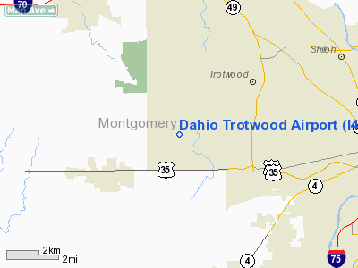
Dahio Trotwood Airport (FAA LID: I44), also known as Dayton-New Lebanon Airport, is a public-use airport located seven miles (11 km) west of the central business district of Dayton, in Montgomery County, Ohio, United States. It is privately owned by Gary Ridell. The airport is situated between Trotwood to the northeast and New Lebanon to the southwest.
Facilities and aircraft
Dahio Trotwood Airport covers an area of 132 acres (53 ha) which contains one asphalt paved runway measuring 2,900 x 52 ft (884 x 16 m).
For the 12-month period ending May 29, 2007, the airport had 1,853 aircraft operations, an average of 5 per day, 100% which were general aviation. There are 27 aircraft based at this airport: 16 single-engine, 10 ultralight and 1 multi-engine.
The above content comes from Wikipedia and is published under free licenses – click here to read more.
Location & QuickFacts
| FAA Information Effective: | 2008-09-25 |
| Airport Identifier: | I44 |
| Airport Status: | Operational |
| Longitude/Latitude: | 084-20-35.8020W/39-45-57.2030N
-84.343278/39.765890 (Estimated) |
| Elevation: | 925 ft / 281.94 m (Estimated) |
| Land: | 132 acres |
| From nearest city: | 7 nautical miles W of Dayton, OH |
| Location: | Montgomery County, OH |
| Magnetic Variation: | 04W (1985) |
Owner & Manager
| Ownership: | Privately owned |
| Owner: | Gary Riddell |
| Address: | 1334 N Lutheran Church Rd
Dayton, OH 45427 |
| Phone number: | 937-854-1406
MANAGER CELL PHONE 937-604-8899 |
| Manager: | Gary Riddell |
| Address: | 1334 N Lutheran Church Rd
Dayton, OH 45427 |
| Phone number: | 937-854-1406
MANAGER CELL PHONE 937-604-8899 |
Airport Operations and Facilities
| Airport Use: | Open to public |
| Wind indicator: | Yes |
| Segmented Circle: | No |
| Control Tower: | No |
| Lighting Schedule: | DUSK-DAWN |
| Beacon Color: | Clear-Green (lighted land airport)
ARPT BCN OTS INDEFLY. |
| Landing fee charge: | No |
| Sectional chart: | Cincinnati |
| Region: | AGL - Great Lakes |
| Boundary ARTCC: | ZID - Indianapolis |
| Tie-in FSS: | DAY - Dayton |
| FSS on Airport: | No |
| FSS Toll Free: | 1-800-WX-BRIEF |
| NOTAMs Facility: | DAY (NOTAM-d service avaliable) |
Airport Communications
| CTAF: | 122.800 |
| Unicom: | 122.800 |
Airport Services
| Fuel available: | 100LL |
| Airframe Repair: | MAJOR |
| Bottled Oxygen: | NONE |
| Bulk Oxygen: | NONE |
Runway Information
Runway 04/22
| Dimension: | 2900 x 52 ft / 883.9 x 15.8 m |
| Surface: | ASPH, Good Condition |
| |
Runway 04 |
Runway 22 |
| Longitude: | 084-20-47.2600W | 084-20-22.0600W |
| Latitude: | 39-45-43.8800N | 39-46-04.8800N |
| Elevation: | 925.00 ft | 925.00 ft |
| Traffic Pattern: | Left | Left |
| Runway End Identifier: | No | No |
| Centerline Lights: | No | No |
| Touchdown Lights: | No | No |
| Obstruction: | 68 ft trees, 717.0 ft from runway, 120 ft right of centerline, 7:1 slope to clear | 20 ft trees, 201.0 ft from runway, 100 ft left of centerline
RWY 22 20 FT TREES 200 FT FM RWY END 20 FT L; +4 FT FENCE AND CROPS 0 FT FM RWY END 125 FT R/L. |
|
Radio Navigation Aids
| ID |
Type |
Name |
Ch |
Freq |
Var |
Dist |
| HKF | NDB | Hook Field | | 239.00 | 04W | 16.8 nm |
| XEN | NDB | Xenia | | 395.00 | 03W | 19.3 nm |
| OXD | NDB | Oxford | | 282.00 | 04W | 25.5 nm |
| HAO | NDB | Hamilton | | 260.00 | 04W | 25.9 nm |
| CCJ | NDB | Clark County | | 341.00 | 04W | 26.8 nm |
| VES | NDB | Versailles | | 356.00 | 04W | 27.7 nm |
| ISZ | NDB | Cincinnati-blue Ash | | 388.00 | 04W | 31.2 nm |
| IL | NDB | Airbo | | 407.00 | 04W | 32.6 nm |
| MDE | NDB | Madeira | | 379.00 | 04W | 32.7 nm |
| HW | NDB | Cubla | | 299.00 | 04W | 32.9 nm |
| LUK | NDB | Cincinnati | | 335.00 | 04W | 36.4 nm |
| UYF | NDB | London | | 263.00 | 06W | 41.7 nm |
| PWF | NDB | Sportys | | 245.00 | 04W | 41.8 nm |
| EDJ | NDB | Bellefontaine | | 242.00 | 05W | 43.8 nm |
| CQA | NDB | Lakefield | | 205.00 | 04W | 44.2 nm |
| CSS | NDB | Court House | | 414.00 | 05W | 45.1 nm |
| UWL | NDB | New Castle | | 385.00 | 02W | 45.6 nm |
| UR | NDB | Burln | | 321.00 | 04W | 47.7 nm |
| HLB | NDB | Batesville | | 254.00 | 02W | 49.2 nm |
| FFO | TACAN | Patterson | 099X | | 04W | 13.7 nm |
| XSF | TACAN | Springfield | 065X | | 04W | 23.6 nm |
| DQN | VOR/DME | Dayton | 092X | 114.50 | 01W | 15.3 nm |
| SGH | VOR/DME | Springfield | 079X | 113.20 | 04W | 23.4 nm |
| MXQ | VOR/DME | Midwest | 076X | 112.90 | 04W | 32.2 nm |
| RID | VORTAC | Richmond | 043X | 110.60 | 03W | 22.9 nm |
| ROD | VORTAC | Rosewood | 122X | 117.50 | 05W | 34.3 nm |
| CVG | VORTAC | Cincinnati | 120X | 117.30 | 04W | 48.1 nm |
| DAY | VOT | Dayton J M Cox-day | | 111.00 | | 10.0 nm |
| LUK | VOT | Cincinnati Muni/lunken | | 108.40 | | 39.1 nm |
Remarks
- ULTRALIGHTS ON & INVOF ARPT.
Images and information placed above are from
http://www.airport-data.com/airport/I44/
We thank them for the data!
| General Info
|
| Country |
United States
|
| State |
OHIO
|
| FAA ID |
I44
|
| Latitude |
39-45-57.203N
|
| Longitude |
084-20-35.802W
|
| Elevation |
925 feet
|
| Near City |
DAYTON
|
We don't guarantee the information is fresh and accurate. The data may
be wrong or outdated.
For more up-to-date information please refer to other sources.
|
|


