 |
|
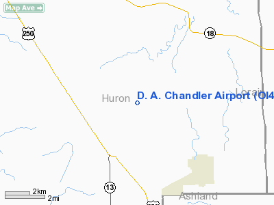
Location & QuickFacts
| FAA Information Effective: | 2008-09-25 |
| Airport Identifier: | OI42 |
| Airport Status: | Operational |
| Longitude/Latitude: | 082-27-38.6090W/41-07-58.1930N
-82.460725/41.132831 (Estimated) |
| Elevation: | 950 ft / 289.56 m (Estimated) |
| Land: | 0 acres |
| From nearest city: | 4 nautical miles NW of New London, OH |
| Location: | Huron County, OH |
| Magnetic Variation: | 06W (1985) |
Owner & Manager
| Ownership: | Privately owned |
| Owner: | Donald A. Chandler |
| Address: | Box 3436 Prospect Road
New London, OH 44851 |
| Phone number: | 419-734-1331 |
| Manager: | Donald A. Chandler |
| Address: | Box 3436 Prospect Road
New London, OH 44851 |
| Phone number: | 419-734-1331 |
Airport Operations and Facilities
| Airport Use: | Private |
| Wind indicator: | Yes |
| Segmented Circle: | No |
| Control Tower: | No |
| Beacon Color: | Clear (unlighted land airport) |
| Landing fee charge: | No |
| Sectional chart: | Detroit |
| Region: | AGL - Great Lakes |
| Boundary ARTCC: | ZOB - Cleveland |
| Tie-in FSS: | CLE - Cleveland |
| FSS on Airport: | No |
| FSS Toll Free: | 1-800-WX-BRIEF |
Runway Information
Runway 09/27
| Dimension: | 2000 x 75 ft / 609.6 x 22.9 m |
| Surface: | TURF, |
| |
Runway 09 |
Runway 27 |
| Traffic Pattern: | Left | Left |
|
Radio Navigation Aids
| ID |
Type |
Name |
Ch |
Freq |
Var |
Dist |
| AAU | NDB | Ashland | | 329.00 | 07W | 13.9 nm |
| MF | NDB | Manns | | 372.00 | 06W | 22.1 nm |
| CL | NDB | Harri | | 344.00 | 07W | 25.6 nm |
| PCW | NDB | Port Clinton | | 423.00 | 06W | 29.6 nm |
| TII | NDB | Tiffin | | 269.00 | 05W | 33.9 nm |
| EZE | NDB | Engel | | 226.00 | 07W | 39.6 nm |
| PT | NDB | Pelee Island | | 283.00 | 05W | 40.0 nm |
| MNN | NDB | Marion | | 201.00 | 05W | 41.6 nm |
| FZI | NDB | Fostoria | | 379.00 | 05W | 42.5 nm |
| BKL | NDB | Burke Lakefront | | 416.00 | 07W | 43.1 nm |
| MLR | NDB | Millersburg/dcmsnd | | 382.00 | 06W | 44.5 nm |
| AK | NDB | Akron | | 362.00 | 07W | 48.8 nm |
| BUD | VOR | Buckeye | | 109.80 | 05W | 41.4 nm |
| DJB | VOR/DME | Dryer | 083X | 113.60 | 05W | 19.1 nm |
| SKY | VOR/DME | Sandusky | 029X | 109.20 | 04W | 20.1 nm |
| TVT | VOR/DME | Tiverton | 112X | 116.50 | 03W | 43.3 nm |
| MFD | VORTAC | Mansfield | 025X | 108.80 | 03W | 16.9 nm |
| CLE | VOT | Cleveland | | 110.40 | | 32.3 nm |
| CAK | VOT | Akron/canton Regional | | 110.60 | | 48.0 nm |
Remarks
- BECAUSE HANGAR IS AN OBSTN IN PRIMARY SURFACE; AVBL DATA INDICATES THAT THE USABLE RWY LENGTH AND OBSTN CLEARANCES DO NOT OFFER AN ACCEPTABLE;. LEVEL OF SAFETY FOR ACFT OPERATIONS.
Images and information placed above are from
http://www.airport-data.com/airport/OI42/
We thank them for the data!
| General Info
|
| Country |
United States
|
| State |
OHIO
|
| FAA ID |
OI42
|
| Latitude |
41-07-58.193N
|
| Longitude |
082-27-38.609W
|
| Elevation |
950 feet
|
| Near City |
NEW LONDON
|
We don't guarantee the information is fresh and accurate. The data may
be wrong or outdated.
For more up-to-date information please refer to other sources.
|
|


