 |
|
Cuyahoga County Airport
Robert D. Shea Field |
 |
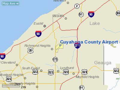
| FAA diagram of Cuyahoga County Airport |
| IATA: CGF – ICAO: KCGF |
| Summary |
| Airport type |
Public |
| Operator |
Cuyahoga County |
| Serves |
Cleveland, Ohio |
| Location |
Highland Heights
Richmond Heights
Willoughby Hills |
| Elevation AMSL |
879 ft / 267.9 m |
| Coordinates |
41°33′54.44″N 81°29′10.87″W / 41.5651222°N 81.4863528°W / 41.5651222; -81.4863528Coordinates: 41°33′54.44″N 81°29′10.87″W / 41.5651222°N 81.4863528°W / 41.5651222; -81.4863528 |
| Website |
Cuyahoga County Airport |
| Runways |
| Direction |
Length |
Surface |
| ft |
m |
| 6/24 |
5,102 |
1,555 |
Asphalt |
Cuyahoga County Airport (IATA: CGF, ICAO: KCGF), also known as Robert D. Shea Field, is an airport located in northeastern Cuyahoga County, Ohio, about 10 miles (16 km) east of Cleveland, Ohio, and sits on the border of three cities: Highland Heights, Richmond Heights and Willoughby Hills (Lake County). Facilities
Cuyahoga County Airport covers 640 acres (259 ha) and has one runway:
- Runway 6/24: 5,102 x 100 ft (1,555 x 30 m), Surface: Asphalt
- Fuel available: 100LL JET-A JET-A1+
- Parking: hangars and tiedowns
- Airframe service: MAJOR
- Powerplant service: MAJOR
- Bottled oxygen: HIGH
- Bulk oxygen: NONE
Airport operational statistics
- Aircraft based on the field: 206
- Single engine airplanes: 96
- Multi engine airplanes: 18
- Jet airplanes: 91
- Helicopters: 1
- Aircraft operations: avg 185/day
- 53% transient general aviation
- 27% local general aviation
- 20% air taxi
- <1% military
Airlines
- Corporate Wings
- Hangars, Terminal Lounge, Aircraft Cleaning/Maintenance.
- Flight Options
The above content comes from Wikipedia and is published under free licenses – click here to read more.
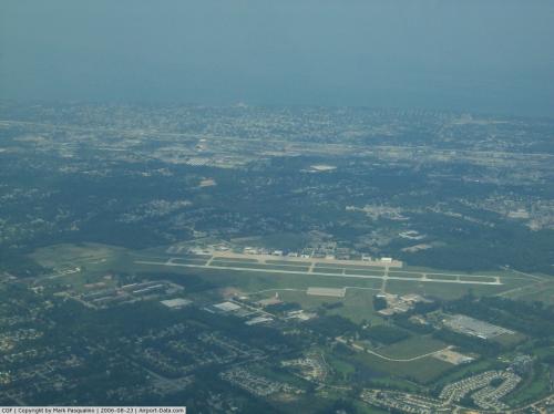 |
(Click on the photo to enlarge) |
Location & QuickFacts
| FAA Information Effective: | 2008-09-25 |
| Airport Identifier: | CGF |
| Airport Status: | Operational |
| Longitude/Latitude: | 081-29-10.8799W/41-33-54.4464N
-81.486356/41.565124 (Estimated) |
| Elevation: | 879 ft / 267.92 m (Surveyed) |
| Land: | 640 acres |
| From nearest city: | 10 nautical miles E of Cleveland, OH |
| Location: | Cuyahoga County, OH |
| Magnetic Variation: | 08W (1995) |
Owner & Manager
| Ownership: | Publicly owned |
| Owner: | Cuyahoga County |
| Address: | 26300 Curtis Wright Parkway
Cleveland, OH 44113 |
| Phone number: | 216-289-4111 |
| Manager: | Steve Nagy |
| Address: | 26300 Curtis Wright Parkway
Cleveland, OH 44143 |
| Phone number: | 216-289-4111 |
Airport Operations and Facilities
| Airport Use: | Open to public |
| Wind indicator: | Yes |
| Segmented Circle: | Yes |
| Control Tower: | Yes |
| Lighting Schedule: | 24 HRS
WHEN ATCT CLSD ACTVT HIRL RY 06/24, REIL RY 06, MALSR RY 24 - CTAF. PAPI RY 06, PAPI RY 24 & WINDSOCK OPERATE 24 HRS. |
| Beacon Color: | Clear-Green (lighted land airport) |
| Landing fee charge: | Yes
PARKING FEE FOR OVER TWO HOURS. |
| Sectional chart: | Detroit |
| Region: | AGL - Great Lakes |
| Boundary ARTCC: | ZOB - Cleveland |
| Tie-in FSS: | CLE - Cleveland |
| FSS on Airport: | No |
| FSS Toll Free: | 1-800-WX-BRIEF
OR LOCAL CALL 267-3700. |
| NOTAMs Facility: | CGF (NOTAM-d service avaliable) |
| Federal Agreements: | NGY |
Airport Communications
| CTAF: | 118.500 |
| Unicom: | 122.950 |
Airport Services
| Fuel available: | 100LLA A1+ |
| Airframe Repair: | MAJOR |
| Power Plant Repair: | MAJOR |
| Bottled Oxygen: | HIGH |
| Bulk Oxygen: | NONE |
Runway Information
Runway 06/24
| Dimension: | 5102 x 100 ft / 1555.1 x 30.5 m |
| Surface: | ASPH, Fair Condition |
| Surface Treatment: | Saw-cut or plastic Grooved |
| Weight Limit: | Single wheel: 43000 lbs.
Dual wheel: 55000 lbs.
Dual tandem wheel: 100000 lbs. |
| Edge Lights: | High
HIRL RY 06/24 STEP ONE OTS INDEFLY. |
| |
Runway 06 |
Runway 24 |
| Longitude: | 081-29-36.3860W | 081-28-45.3703W |
| Latitude: | 41-33-38.0727N | 41-34-10.8186N |
| Elevation: | 872.00 ft | 879.00 ft |
| Alignment: | 49 | 127 |
| ILS Type: | | ILS/DME
|
| Traffic Pattern: | Left | Left |
| Markings: | Non-precision instrument, Good Condition | Precision instrument, Good Condition |
| Crossing Height: | 42.00 ft | 50.00 ft |
| VASI: | 4-light PAPI on left side | 4-light PAPI on left side
UNUSBL BYD 7 DEG RIGHT OF COURSE. |
| Visual Glide Angle: | 3.00° | 3.00° |
| Approach lights: | | MALSR |
| Runway End Identifier: | Yes | No |
| Centerline Lights: | No | No |
| Touchdown Lights: | No | No |
| Obstruction: | 18 ft pole, 935.0 ft from runway, 424 ft left of centerline, 40:1 slope to clear | 68 ft trees, 2595.0 ft from runway, 742 ft right of centerline, 35:1 slope to clear |
|
Radio Navigation Aids
| ID |
Type |
Name |
Ch |
Freq |
Var |
Dist |
| BKL | NDB | Burke Lakefront | | 416.00 | 07W | 8.3 nm |
| LQL | NDB | Lakeland | | 263.00 | 08W | 8.5 nm |
| EZE | NDB | Engel | | 226.00 | 07W | 11.6 nm |
| CL | NDB | Harri | | 344.00 | 07W | 25.5 nm |
| AK | NDB | Akron | | 362.00 | 07W | 30.1 nm |
| HBD | NDB | Hubbard | | 408.00 | 08W | 49.7 nm |
| LNN | VOR/DME | Lost Nation | 039X | 110.20 | 08W | 8.4 nm |
| CXR | VOR/DME | Chardon | 074X | 112.70 | 05W | 14.8 nm |
| ACO | VOR/DME | Akron | 091X | 114.40 | 04W | 30.3 nm |
| DJB | VOR/DME | Dryer | 083X | 113.60 | 05W | 32.9 nm |
| JFN | VOR/DME | Jefferson | 099X | 115.20 | 05W | 35.2 nm |
| BSV | VOR/DME | Briggs | 071X | 112.40 | 04W | 49.6 nm |
| YNG | VORTAC | Youngstown | 027X | 109.00 | 05W | 39.2 nm |
| CLE | VOT | Cleveland | | 110.40 | | 18.8 nm |
| CAK | VOT | Akron/canton Regional | | 110.60 | | 39.1 nm |
Remarks
- NOISE ABATEMENT PROCEDURES: AVOID OVERFLIGHT OF SCHOOL 3/4 MILE SW OF ARPT; FLIGHT TRNG BTN 2300-0700 PROHIBITED; ALL TURBO JET/TURBO FAN TRNG PROHIBITED; PATTERN ALTITUDE 1000 FT AGL; 1500 FT AGL JETS/TWINS; ALL ACFT CONTACT AMGR PRIOR TO CONDUCTING OPNS 2300-0700.
- BIRDS & DEER ON & IN VCNTY OF APRT
- TWY A-4 NOT AVBL FOR ACR OPNS WITH MORE THAN 30 PSGR SEATS.
- TWR VISIBILITY SW REDUCED WITHIN 500 FT AER 06.
- RY 06/24 CLSD TO JET ACFT WITH MORE THAN 30 PSGR.
Images and information placed above are from
http://www.airport-data.com/airport/CGF/
We thank them for the data!
| General Info
|
| Country |
United States
|
| State |
OHIO
|
| FAA ID |
CGF
|
| Latitude |
41-33-54.446N
|
| Longitude |
081-29-10.874W
|
| Elevation |
879 feet
|
| Near City |
CLEVELAND
|
We don't guarantee the information is fresh and accurate. The data may
be wrong or outdated.
For more up-to-date information please refer to other sources.
|
|


