 |
|
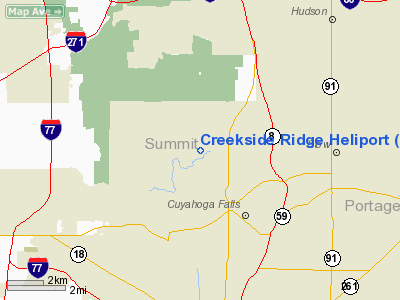
Location & QuickFacts
| FAA Information Effective: | 2008-09-25 |
| Airport Identifier: | OA18 |
| Airport Status: | Operational |
| Longitude/Latitude: | 081-31-36.5000W/41-10-41.8800N
-81.526806/41.178300 (Estimated) |
| Elevation: | 1081 ft / 329.49 m (Estimated) |
| Land: | 0 acres |
| From nearest city: | 9 nautical miles NW of Cuyahoga Falls, OH |
| Location: | Summit County, OH |
| Magnetic Variation: | () |
Owner & Manager
| Ownership: | Privately owned |
| Owner: | Daniel E. Karam |
| Address: | 265 W. Portage Trail
Cuyahoga Falls, OH 44223 |
| Phone number: | 330-571-0496 |
| Manager: | Daniel E. Karam |
| Address: | 265 W. Portage Trail
Cuyahoga Falls, OH 44223 |
| Phone number: | 330-571-0496 |
Airport Operations and Facilities
| Airport Use: | Private |
| Wind indicator: | Yes |
| Control Tower: | No |
| Sectional chart: | Detroit |
| Region: | AGL - Great Lakes |
| Boundary ARTCC: | ZOB - Cleveland |
| Tie-in FSS: | CLE - Cleveland |
| FSS Toll Free: | 1-800-WX-BRIEF |
Runway Information
Helipad H1
| Dimension: | 50 x 50 ft / 15.2 x 15.2 m |
| Surface: | CONC, |
| |
Runway H1 |
Runway |
| Traffic Pattern: | Left | Left |
|
Radio Navigation Aids
| ID |
Type |
Name |
Ch |
Freq |
Var |
Dist |
| AK | NDB | Akron | | 362.00 | 07W | 9.1 nm |
| EZE | NDB | Engel | | 226.00 | 07W | 20.7 nm |
| BKL | NDB | Burke Lakefront | | 416.00 | 07W | 21.9 nm |
| CL | NDB | Harri | | 344.00 | 07W | 22.0 nm |
| LQL | NDB | Lakeland | | 263.00 | 08W | 31.0 nm |
| AAU | NDB | Ashland | | 329.00 | 07W | 35.4 nm |
| MLR | NDB | Millersburg/dcmsnd | | 382.00 | 06W | 41.4 nm |
| TSO | NDB | Tolson | | 395.00 | 07W | 42.3 nm |
| HBD | NDB | Hubbard | | 408.00 | 08W | 45.1 nm |
| MF | NDB | Manns | | 372.00 | 06W | 48.5 nm |
| ACO | VOR/DME | Akron | 091X | 114.40 | 04W | 15.3 nm |
| CXR | VOR/DME | Chardon | 074X | 112.70 | 05W | 26.1 nm |
| BSV | VOR/DME | Briggs | 071X | 112.40 | 04W | 26.7 nm |
| DJB | VOR/DME | Dryer | 083X | 113.60 | 05W | 30.7 nm |
| LNN | VOR/DME | Lost Nation | 039X | 110.20 | 08W | 31.0 nm |
| JFN | VOR/DME | Jefferson | 099X | 115.20 | 05W | 49.5 nm |
| YNG | VORTAC | Youngstown | 027X | 109.00 | 05W | 39.6 nm |
| CAK | VOT | Akron/canton Regional | | 110.60 | | 16.2 nm |
| CLE | VOT | Cleveland | | 110.40 | | 20.2 nm |
Remarks
- PRVDD VFR OPNS, PVT USE, WIND INDICATOR IS MAINTAINED AND AREA IS MAEKED.
Images and information placed above are from
http://www.airport-data.com/airport/OA18/
We thank them for the data!
|
|


