 |
|
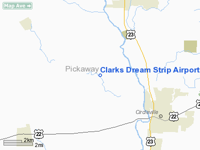
Clarks Dream Strip Airport |
Location & QuickFacts
| FAA Information Effective: | 2008-09-25 |
| Airport Identifier: | 03I |
| Airport Status: | Operational |
| Longitude/Latitude: | 083-01-05.6600W/39-38-39.2240N
-83.018239/39.644229 (Estimated) |
| Elevation: | 680 ft / 207.26 m (Estimated) |
| Land: | 40 acres |
| From nearest city: | 4 nautical miles NW of Circleville, OH |
| Location: | Pickaway County, OH |
| Magnetic Variation: | 05W (1985) |
Owner & Manager
| Ownership: | Privately owned |
| Owner: | Ethel Mc Farland |
| Address: | 20035 Fox Road
Circleville, OH 43113 |
| Phone number: | 740-474-4644 |
| Manager: | Louis Mc Farland |
| Address: | 3490 Mc Clean Mill Rd
Circleville, OH 43113 |
| Phone number: | 740-474-4644 |
Airport Operations and Facilities
| Airport Use: | Open to public |
| Wind indicator: | Yes |
| Segmented Circle: | No |
| Control Tower: | No |
| Landing fee charge: | No |
| Sectional chart: | Cincinnati |
| Region: | AGL - Great Lakes |
| Boundary ARTCC: | ZID - Indianapolis |
| Tie-in FSS: | DAY - Dayton |
| FSS on Airport: | No |
| FSS Toll Free: | 1-800-WX-BRIEF |
| NOTAMs Facility: | DAY (NOTAM-d service avaliable) |
Airport Communications
Airport Services
Runway Information
Runway 13/31
| Dimension: | 2375 x 90 ft / 723.9 x 27.4 m |
| Surface: | TURF, Good Condition |
| |
Runway 13 |
Runway 31 |
| Alignment: | 58 | 127 |
| Traffic Pattern: | Left | Left |
| Runway End Identifier: | No | No |
| Centerline Lights: | No | No |
| Touchdown Lights: | No | No |
| Obstruction: | 80 ft trees, 125 ft right of centerline | 65 ft trees, 193.0 ft from runway, 135 ft right of centerline, 2:1 slope to clear |
|
Radio Navigation Aids
| ID |
Type |
Name |
Ch |
Freq |
Var |
Dist |
| CYO | NDB | Circleville | | 366.00 | 05W | 7.5 nm |
| RZT | NDB | Ross County | | 236.00 | 05W | 12.4 nm |
| BU | NDB | Boutn | | 230.00 | 05W | 13.6 nm |
| CSS | NDB | Court House | | 414.00 | 05W | 17.5 nm |
| CHC | NDB | Grens | | 272.00 | 04W | 22.0 nm |
| CM | NDB | Sumie | | 391.00 | 05W | 23.9 nm |
| DKG | NDB | Don Scott | | 348.00 | 05W | 26.4 nm |
| UYF | NDB | London | | 263.00 | 06W | 27.1 nm |
| OS | NDB | Fuler | | 515.00 | 05W | 27.1 nm |
| EOP | NDB | Waverly | | 385.00 | 06W | 29.0 nm |
| HEH | NDB | Newark | | 524.00 | 06W | 34.4 nm |
| IL | NDB | Airbo | | 407.00 | 04W | 34.5 nm |
| HOC | NDB | Hillsboro | | 278.00 | 05W | 36.8 nm |
| CCJ | NDB | Clark County | | 341.00 | 04W | 37.8 nm |
| MRT | NDB | Marysville | | 403.00 | 05W | 38.2 nm |
| DLZ | NDB | Delaware | | 215.00 | 06W | 38.2 nm |
| XEN | NDB | Xenia | | 395.00 | 03W | 42.4 nm |
| HW | NDB | Cubla | | 299.00 | 04W | 43.4 nm |
| PZO | NDB | Peebles | | 329.00 | 02W | 45.8 nm |
| UGS | NDB | University | | 250.00 | 06W | 47.5 nm |
| LCK | TACAN | Rickenbacker | 069X | | 05W | 10.7 nm |
| XSF | TACAN | Springfield | 065X | | 04W | 39.8 nm |
| FFO | TACAN | Patterson | 099X | | 04W | 49.1 nm |
| XUB | VOR | Yellow Bud | | 112.50 | 05W | 7.3 nm |
| MXQ | VOR/DME | Midwest | 076X | 112.90 | 04W | 38.5 nm |
| SGH | VOR/DME | Springfield | 079X | 113.20 | 04W | 39.9 nm |
| APE | VORTAC | Appleton | 114X | 116.70 | 06W | 36.3 nm |
| CMH | VOT | Port Columbus | | 111.00 | | 21.9 nm |
Remarks
- RWY/TWY/APRON TURF-G. FAR PART 77 VIOL: TREES N,S OF RWY HIGH GND N.
- VFR OPNS ONLY
Images and information placed above are from
http://www.airport-data.com/airport/03I/
We thank them for the data!
| General Info
|
| Country |
United States
|
| State |
OHIO
|
| FAA ID |
03I
|
| Latitude |
39-38-39.224N
|
| Longitude |
083-01-05.660W
|
| Elevation |
680 feet
|
| Near City |
CIRCLEVILLE
|
We don't guarantee the information is fresh and accurate. The data may
be wrong or outdated.
For more up-to-date information please refer to other sources.
|
|


