 |
|
Location & QuickFacts
| FAA Information Effective: | 2008-09-25 |
| Airport Identifier: | 81OI |
| Airport Status: | Operational |
| Longitude/Latitude: | 084-36-06.8000W/39-04-50.2150N
-84.601889/39.080615 (Estimated) |
| Elevation: | 870 ft / 265.18 m (Estimated) |
| Land: | 2 acres |
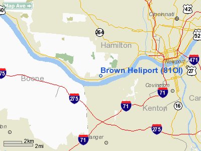
| From nearest city: | 5 nautical miles SW of Cincinnati, OH |
| Location: | Hamilton County, OH |
| Magnetic Variation: | 03W (1985) |
Owner & Manager
| Ownership: | Privately owned |
| Owner: | James L. Brown |
| Address: | 171 Pedretti Rd
Cincinnati, OH 45238 |
| Phone number: | 513-921-2191 |
| Manager: | James L. Brown |
| Address: | 171 Pedretti Rd
Cincinnati, OH 45238 |
| Phone number: | 513-921-2191 |
Airport Operations and Facilities
| Airport Use: | Private
PERSONAL USE. |
| Wind indicator: | Yes |
| Segmented Circle: | No |
| Control Tower: | No |
| Sectional chart: | St Louis |
| Region: | AGL - Great Lakes |
| Boundary ARTCC: | ZID - Indianapolis |
| Tie-in FSS: | DAY - Dayton |
| FSS Toll Free: | 1-800-WX-BRIEF |
Runway Information
Helipad H1
| Dimension: | 250 x 200 ft / 76.2 x 61.0 m |
| Surface: | TURF, |
| |
Runway H1 |
Runway |
| Traffic Pattern: | Left | Left |
|
Radio Navigation Aids
| ID |
Type |
Name |
Ch |
Freq |
Var |
Dist |
| UR | NDB | Burln | | 321.00 | 04W | 8.3 nm |
| LUK | NDB | Cincinnati | | 335.00 | 04W | 13.0 nm |
| ISZ | NDB | Cincinnati-blue Ash | | 388.00 | 04W | 14.1 nm |
| MDE | NDB | Madeira | | 379.00 | 04W | 14.3 nm |
| HAO | NDB | Hamilton | | 260.00 | 04W | 17.6 nm |
| PWF | NDB | Sportys | | 245.00 | 04W | 18.0 nm |
| HKF | NDB | Hook Field | | 239.00 | 04W | 26.1 nm |
| OXD | NDB | Oxford | | 282.00 | 04W | 27.0 nm |
| HLB | NDB | Batesville | | 254.00 | 02W | 34.6 nm |
| HW | NDB | Cubla | | 299.00 | 04W | 37.6 nm |
| IMS | NDB | Madison | | 404.00 | 03W | 44.5 nm |
| OVO | NDB | North Vernon | | 374.00 | 02W | 46.7 nm |
| IL | NDB | Airbo | | 407.00 | 04W | 47.2 nm |
| XEN | NDB | Xenia | | 395.00 | 03W | 49.3 nm |
| HOC | NDB | Hillsboro | | 278.00 | 05W | 49.8 nm |
| FLM | VOR/DME | Falmouth | 117X | 117.00 | 04W | 29.3 nm |
| MXQ | VOR/DME | Midwest | 076X | 112.90 | 04W | 42.8 nm |
| CVG | VORTAC | Cincinnati | 120X | 117.30 | 04W | 6.1 nm |
| RID | VORTAC | Richmond | 043X | 110.60 | 03W | 42.0 nm |
| LUK | VOT | Cincinnati Muni/lunken | | 108.40 | | 9.7 nm |
Remarks
- PRVDD OPERS ARE COND FM 090 TO 125 DEG; FM 160 TO 270 DEG; & FM 330 TO 030 DEG; AREA IS MKD; WND IND IS MAINTAINED.
Images and information placed above are from
http://www.airport-data.com/airport/81OI/
We thank them for the data!
| General Info
|
| Country |
United States
|
| State |
OHIO
|
| FAA ID |
81OI
|
| Latitude |
39-04-50.215N
|
| Longitude |
084-36-06.800W
|
| Elevation |
870 feet
|
| Near City |
CINCINNATI
|
We don't guarantee the information is fresh and accurate. The data may
be wrong or outdated.
For more up-to-date information please refer to other sources.
|
|


