 |
|
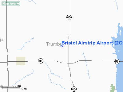
Location & QuickFacts
| FAA Information Effective: | 2008-09-25 |
| Airport Identifier: | 2OA1 |
| Airport Status: | Operational |
| Longitude/Latitude: | 080-53-03.3160W/41-24-54.2000N
-80.884254/41.415056 (Estimated) |
| Elevation: | 865 ft / 263.65 m (Estimated) |
| Land: | 3 acres |
| From nearest city: | 2 nautical miles NW of Bristolville, OH |
| Location: | Trumbull County, OH |
| Magnetic Variation: | 07W (1985) |
Owner & Manager
| Ownership: | Privately owned |
| Owner: | Vernon O. Morrison |
| Address: | 2041 Messick S. Road
North Bloomfield, OH 44450 |
| Phone number: | 330-889-3387 |
| Manager: | Vernon O. Morrison |
| Address: | 2041 Messick S. Road
North Bloomfield, OH 44450 |
| Phone number: | 330-889-3387 |
Airport Operations and Facilities
| Airport Use: | Private |
| Wind indicator: | No |
| Segmented Circle: | No |
| Control Tower: | No |
| Landing fee charge: | No |
| Sectional chart: | Detroit |
| Region: | AGL - Great Lakes |
| Boundary ARTCC: | ZOB - Cleveland |
| Tie-in FSS: | CLE - Cleveland |
| FSS on Airport: | No |
| FSS Toll Free: | 1-800-WX-BRIEF |
Airport Services
| Airframe Repair: | NONE |
| Power Plant Repair: | NONE |
Runway Information
Runway 09/27
| Dimension: | 2100 x 100 ft / 640.1 x 30.5 m |
| Surface: | TURF, Good Condition |
| |
Runway 09 |
Runway 27 |
| Traffic Pattern: | Left | Left |
| Obstruction: | 40 ft trees, 850.0 ft from runway, 26:1 slope to clear | 70 ft trees, 1400.0 ft from runway, 100 ft right of centerline, 20:1 slope to clear |
|
Radio Navigation Aids
| ID |
Type |
Name |
Ch |
Freq |
Var |
Dist |
| HBD | NDB | Hubbard | | 408.00 | 08W | 22.4 nm |
| LQL | NDB | Lakeland | | 263.00 | 08W | 27.5 nm |
| AK | NDB | Akron | | 362.00 | 07W | 30.8 nm |
| UCP | NDB | Castle | | 272.00 | 09W | 31.7 nm |
| BKL | NDB | Burke Lakefront | | 416.00 | 07W | 35.7 nm |
| EZE | NDB | Engel | | 226.00 | 07W | 38.0 nm |
| CL | NDB | Harri | | 344.00 | 07W | 48.9 nm |
| FKL | VOR | Franklin | | 109.60 | 06W | 46.3 nm |
| CXR | VOR/DME | Chardon | 074X | 112.70 | 05W | 14.0 nm |
| JFN | VOR/DME | Jefferson | 099X | 115.20 | 05W | 21.6 nm |
| ACO | VOR/DME | Akron | 091X | 114.40 | 04W | 23.4 nm |
| LNN | VOR/DME | Lost Nation | 039X | 110.20 | 08W | 27.9 nm |
| BSV | VOR/DME | Briggs | 071X | 112.40 | 04W | 47.5 nm |
| YNG | VORTAC | Youngstown | 027X | 109.00 | 05W | 10.7 nm |
| ERI | VORTAC | Erie | 031X | 109.40 | 06W | 44.9 nm |
| EWC | VORTAC | Ellwood City | 105X | 115.80 | 08W | 46.7 nm |
| CAK | VOT | Akron/canton Regional | | 110.60 | | 39.2 nm |
| CLE | VOT | Cleveland | | 110.40 | | 43.5 nm |
Remarks
Images and information placed above are from
http://www.airport-data.com/airport/2OA1/
We thank them for the data!
| General Info
|
| Country |
United States
|
| State |
OHIO
|
| FAA ID |
2OA1
|
| Latitude |
41-24-54.200N
|
| Longitude |
080-53-03.316W
|
| Elevation |
865 feet
|
| Near City |
BRISTOLVILLE
|
We don't guarantee the information is fresh and accurate. The data may
be wrong or outdated.
For more up-to-date information please refer to other sources.
|
|


