 |
|
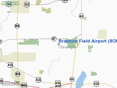
Location & QuickFacts
| FAA Information Effective: | 2008-09-25 |
| Airport Identifier: | 8OI0 |
| Airport Status: | Operational |
| Longitude/Latitude: | 081-14-43.3710W/41-27-15.1880N
-81.245381/41.454219 (Estimated) |
| Elevation: | 1250 ft / 381.00 m (Estimated) |
| Land: | 0 acres |
| From nearest city: | 1 nautical miles S of Newbury, OH |
| Location: | Geauga County, OH |
| Magnetic Variation: | 07W (1985) |
Owner & Manager
| Ownership: | Privately owned |
| Owner: | Robert H. Touzalin |
| Address: | 11061 Music Street
Newbury, OH 44065 |
| Phone number: | 216-564-1144 |
| Address: |
|
Airport Operations and Facilities
| Airport Use: | Private |
| Segmented Circle: | No |
| Control Tower: | No |
| Sectional chart: | Detroit |
| Region: | AGL - Great Lakes |
| Boundary ARTCC: | ZOB - Cleveland |
| Tie-in FSS: | CLE - Cleveland |
| FSS on Airport: | No |
| FSS Toll Free: | 1-800-WX-BRIEF |
Runway Information
Runway 18/36
| Dimension: | 1500 x 100 ft / 457.2 x 30.5 m |
| Surface: | TURF, |
| |
Runway 18 |
Runway 36 |
| Traffic Pattern: | Left | Left |
| Obstruction: | | 50 ft plines, 50.0 ft from runway |
|
Radio Navigation Aids
| ID |
Type |
Name |
Ch |
Freq |
Var |
Dist |
| LQL | NDB | Lakeland | | 263.00 | 08W | 15.0 nm |
| BKL | NDB | Burke Lakefront | | 416.00 | 07W | 19.3 nm |
| EZE | NDB | Engel | | 226.00 | 07W | 21.6 nm |
| AK | NDB | Akron | | 362.00 | 07W | 24.0 nm |
| CL | NDB | Harri | | 344.00 | 07W | 33.2 nm |
| HBD | NDB | Hubbard | | 408.00 | 08W | 37.0 nm |
| UCP | NDB | Castle | | 272.00 | 09W | 45.6 nm |
| CXR | VOR/DME | Chardon | 074X | 112.70 | 05W | 5.3 nm |
| LNN | VOR/DME | Lost Nation | 039X | 110.20 | 08W | 15.3 nm |
| ACO | VOR/DME | Akron | 091X | 114.40 | 04W | 20.9 nm |
| JFN | VOR/DME | Jefferson | 099X | 115.20 | 05W | 28.9 nm |
| DJB | VOR/DME | Dryer | 083X | 113.60 | 05W | 41.7 nm |
| BSV | VOR/DME | Briggs | 071X | 112.40 | 04W | 43.7 nm |
| YNG | VORTAC | Youngstown | 027X | 109.00 | 05W | 26.8 nm |
| CLE | VOT | Cleveland | | 110.40 | | 27.3 nm |
| CAK | VOT | Akron/canton Regional | | 110.60 | | 33.5 nm |
Remarks
- LACK OF SUFFICIENT AIRSPACE TO ESTABLISH AN ARPT TRAFFIC PATTERN AT BRANNON WHICH WOULD NOT CONFLICT WITH THE EXISTING BUCKS AIRPORT TRAFFIC PATTERN AIRSPACE.
Images and information placed above are from
http://www.airport-data.com/airport/8OI0/
We thank them for the data!
| General Info
|
| Country |
United States
|
| State |
OHIO
|
| FAA ID |
8OI0
|
| Latitude |
41-27-15.188N
|
| Longitude |
081-14-43.371W
|
| Elevation |
1250 feet
|
| Near City |
NEWBURY
|
We don't guarantee the information is fresh and accurate. The data may
be wrong or outdated.
For more up-to-date information please refer to other sources.
|
|


