 |
|
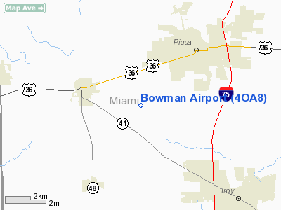
Location & QuickFacts
| FAA Information Effective: | 2008-09-25 |
| Airport Identifier: | 4OA8 |
| Airport Status: | Operational |
| Longitude/Latitude: | 084-17-59.0000W/40-06-31.0000N
-84.299722/40.108611 (Estimated) |
| Elevation: | 980 ft / 298.70 m (Estimated) |
| Land: | 0 acres |
| From nearest city: | 2 nautical miles SW of Piqua, OH |
| Location: | Miami County, OH |
| Magnetic Variation: | () |
Owner & Manager
| Ownership: | Privately owned |
| Owner: | Les Bowman |
| Address: | 4950 W Bausman Rd
Piqua, OH 45356 |
| Phone number: | 937-773-4880 |
| Manager: | Les Bowman |
| Address: | 4950 W Bausman Rd
Piqua, OH 45356 |
| Phone number: | 937-773-4880 |
Airport Operations and Facilities
| Airport Use: | Private |
| Control Tower: | No |
| Lighting Schedule: | RDO-CTL
ACTVT LIRL RY 18/36 - 122.725. |
| Sectional chart: | Detroit |
| Region: | AGL - Great Lakes |
| Traffic Pattern Alt: | 400 ft |
| Boundary ARTCC: | ZID - Indianapolis |
| Tie-in FSS: | DAY - Dayton |
| FSS Toll Free: | 1-800-WX-BRIEF |
Runway Information
Runway 18/36
| Dimension: | 2000 x 100 ft / 609.6 x 30.5 m |
| Surface: | TURF, |
| Edge Lights: | Low |
| |
Runway 18 |
Runway 36 |
| Traffic Pattern: | Left | Right |
|
Radio Navigation Aids
| ID |
Type |
Name |
Ch |
Freq |
Var |
Dist |
| VES | NDB | Versailles | | 356.00 | 04W | 11.8 nm |
| CQA | NDB | Lakefield | | 205.00 | 04W | 25.5 nm |
| EDJ | NDB | Bellefontaine | | 242.00 | 05W | 27.3 nm |
| CCJ | NDB | Clark County | | 341.00 | 04W | 27.8 nm |
| XEN | NDB | Xenia | | 395.00 | 03W | 29.1 nm |
| RUV | NDB | Rushsylvania | | 326.00 | 05W | 35.8 nm |
| HKF | NDB | Hook Field | | 239.00 | 04W | 37.3 nm |
| PLD | NDB | Portland | | 257.00 | 03W | 37.6 nm |
| LYL | NDB | Lima | | 362.00 | 04W | 38.0 nm |
| UYF | NDB | London | | 263.00 | 06W | 39.8 nm |
| OXD | NDB | Oxford | | 282.00 | 04W | 42.4 nm |
| MRT | NDB | Marysville | | 403.00 | 05W | 44.2 nm |
| IL | NDB | Airbo | | 407.00 | 04W | 45.3 nm |
| HAO | NDB | Hamilton | | 260.00 | 04W | 46.0 nm |
| VFU | NDB | Stanley | | 411.00 | 05W | 47.5 nm |
| UWL | NDB | New Castle | | 385.00 | 02W | 48.9 nm |
| HW | NDB | Cubla | | 299.00 | 04W | 49.4 nm |
| FFO | TACAN | Patterson | 099X | | 04W | 20.7 nm |
| XSF | TACAN | Springfield | 065X | | 04W | 26.7 nm |
| AOH | VOR | Allen County | | 108.40 | 04W | 39.0 nm |
| DQN | VOR/DME | Dayton | 092X | 114.50 | 01W | 7.1 nm |
| SGH | VOR/DME | Springfield | 079X | 113.20 | 04W | 26.6 nm |
| MXQ | VOR/DME | Midwest | 076X | 112.90 | 04W | 46.9 nm |
| ROD | VORTAC | Rosewood | 122X | 117.50 | 05W | 16.0 nm |
| RID | VORTAC | Richmond | 043X | 110.60 | 03W | 32.7 nm |
| DAY | VOT | Dayton J M Cox-day | | 111.00 | | 13.0 nm |
Remarks
- ALL TFC REMAIN EAST OF ARPT.
- PRVDD CLEAR 20:1 APCHS, CLEAR OBSTACLE FREE ZONE, AREA IS MKD, TFC PATTERN ALT IS MAX 400 FT AGL, AND ALL TFC FLOWN E OF ARPT TO DECONFLICT WITH PATTERNS AT PIQUA ARPT.
Images and information placed above are from
http://www.airport-data.com/airport/4OA8/
We thank them for the data!
|
|


