 |
|
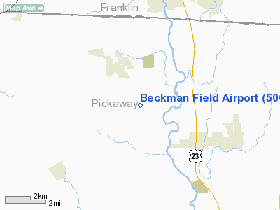
Location & QuickFacts
| FAA Information Effective: | 2008-09-25 |
| Airport Identifier: | 50OI |
| Airport Status: | Operational |
| Longitude/Latitude: | 083-02-17.6640W/39-44-33.2250N
-83.038240/39.742562 (Estimated) |
| Elevation: | 760 ft / 231.65 m (Estimated) |
| Land: | 0 acres |
| From nearest city: | 4 nautical miles NW of Ashville, OH |
| Location: | Pickaway County, OH |
| Magnetic Variation: | 05W (1980) |
Owner & Manager
| Ownership: | Privately owned |
| Owner: | Robert Beckman |
| Address: | 13163 Walker Rd
Ashville, OH 43103 |
| Phone number: | 614-983-2838 |
| Manager: | Robert Beckman |
| Address: | 13163 Walker Rd
Ashville, OH 43103 |
| Phone number: | 614-983-3531 |
Airport Operations and Facilities
| Airport Use: | Private
PERSONAL USE. |
| Wind indicator: | Yes |
| Segmented Circle: | No |
| Control Tower: | No |
| Sectional chart: | Cincinnati |
| Region: | AGL - Great Lakes |
| Boundary ARTCC: | ZID - Indianapolis |
| Tie-in FSS: | DAY - Dayton |
| FSS Toll Free: | 1-800-WX-BRIEF |
Runway Information
Runway 06/24
| Dimension: | 1900 x 75 ft / 579.1 x 22.9 m |
| Surface: | TURF, |
| |
Runway 06 |
Runway 24 |
| Traffic Pattern: | Left | Left |
| Obstruction: | | 40 ft pline, 500.0 ft from runway |
|
Radio Navigation Aids
| ID |
Type |
Name |
Ch |
Freq |
Var |
Dist |
| BU | NDB | Boutn | | 230.00 | 05W | 9.0 nm |
| CYO | NDB | Circleville | | 366.00 | 05W | 13.5 nm |
| CHC | NDB | Grens | | 272.00 | 04W | 16.1 nm |
| RZT | NDB | Ross County | | 236.00 | 05W | 18.3 nm |
| CSS | NDB | Court House | | 414.00 | 05W | 18.4 nm |
| CM | NDB | Sumie | | 391.00 | 05W | 19.6 nm |
| DKG | NDB | Don Scott | | 348.00 | 05W | 20.4 nm |
| OS | NDB | Fuler | | 515.00 | 05W | 21.2 nm |
| UYF | NDB | London | | 263.00 | 06W | 22.9 nm |
| HEH | NDB | Newark | | 524.00 | 06W | 31.5 nm |
| DLZ | NDB | Delaware | | 215.00 | 06W | 32.3 nm |
| MRT | NDB | Marysville | | 403.00 | 05W | 32.4 nm |
| EOP | NDB | Waverly | | 385.00 | 06W | 34.9 nm |
| CCJ | NDB | Clark County | | 341.00 | 04W | 35.1 nm |
| IL | NDB | Airbo | | 407.00 | 04W | 35.7 nm |
| HOC | NDB | Hillsboro | | 278.00 | 05W | 40.9 nm |
| XEN | NDB | Xenia | | 395.00 | 03W | 41.3 nm |
| HW | NDB | Cubla | | 299.00 | 04W | 45.3 nm |
| LCK | TACAN | Rickenbacker | 069X | | 05W | 6.4 nm |
| XSF | TACAN | Springfield | 065X | | 04W | 37.5 nm |
| FFO | TACAN | Patterson | 099X | | 04W | 47.2 nm |
| XUB | VOR | Yellow Bud | | 112.50 | 05W | 13.3 nm |
| SGH | VOR/DME | Springfield | 079X | 113.20 | 04W | 37.7 nm |
| MXQ | VOR/DME | Midwest | 076X | 112.90 | 04W | 40.0 nm |
| APE | VORTAC | Appleton | 114X | 116.70 | 06W | 32.1 nm |
| CMH | VOT | Port Columbus | | 111.00 | | 16.7 nm |
Remarks
- PRVDD PERSONAL USE ONLY; LOA WITH USAF REGARDING APCH/DEPT ROUTES.
Images and information placed above are from
http://www.airport-data.com/airport/50OI/
We thank them for the data!
| General Info
|
| Country |
United States
|
| State |
OHIO
|
| FAA ID |
50OI
|
| Latitude |
39-44-33.225N
|
| Longitude |
083-02-17.664W
|
| Elevation |
760 feet
|
| Near City |
ASHVILLE
|
We don't guarantee the information is fresh and accurate. The data may
be wrong or outdated.
For more up-to-date information please refer to other sources.
|
|


