|
|
 |
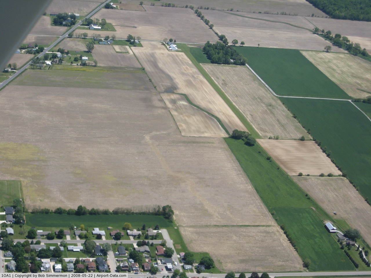
(Click on the photo to enlarge) |
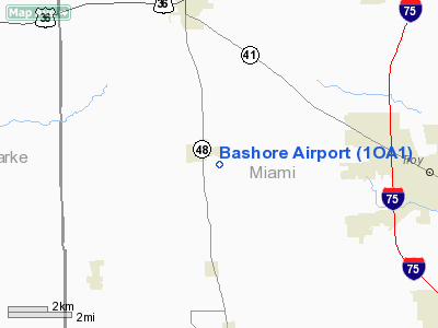
Location & QuickFacts
| FAA Information Effective: | 2008-09-25 |
| Airport Identifier: | 1OA1 |
| Airport Status: | Operational |
| Longitude/Latitude: | 084-20-03.8090W/40-02-45.1860N
-84.334391/40.045885 (Estimated) |
| Elevation: | 940 ft / 286.51 m (Estimated) |
| Land: | 3 acres |
| From nearest city: | 1 nautical miles SE of Pleasant Hill, OH |
| Location: | Miami County, OH |
| Magnetic Variation: | 04W (1985) |
Owner & Manager
| Ownership: | Privately owned |
| Owner: | William Bashore |
| Address: | 504 N Johnson Rd
Pleasant Hill, OH 45359 |
| Phone number: | 937-676-3781 |
| Manager: | Barry Bashore |
| Address: | 555 N St Route 48 Po Box 814
Pleasant Hill, OH 45359-0814 |
| Phone number: | 937-676-2249 |
Airport Operations and Facilities
| Airport Use: | Private |
| Wind indicator: | Yes |
| Segmented Circle: | No |
| Control Tower: | No |
| Landing fee charge: | No |
| Sectional chart: | Detroit |
| Region: | AGL - Great Lakes |
| Boundary ARTCC: | ZID - Indianapolis |
| Tie-in FSS: | DAY - Dayton |
| FSS on Airport: | No |
| FSS Toll Free: | 1-800-WX-BRIEF |
Airport Services
| Airframe Repair: | NONE |
| Power Plant Repair: | NONE |
Runway Information
Runway 09/27
| Dimension: | 2237 x 58 ft / 681.8 x 17.7 m |
| Surface: | TURF, Good Condition |
| |
Runway 09 |
Runway 27 |
| Traffic Pattern: | Right | Left |
| Markings: | Nonstandard, | Nonstandard, |
| Obstruction: | 40 ft trees, 200.0 ft from runway | 30 ft bldg, 200.0 ft from runway |
|
Radio Navigation Aids
| ID |
Type |
Name |
Ch |
Freq |
Var |
Dist |
| VES | NDB | Versailles | | 356.00 | 04W | 13.0 nm |
| XEN | NDB | Xenia | | 395.00 | 03W | 27.3 nm |
| CCJ | NDB | Clark County | | 341.00 | 04W | 27.6 nm |
| CQA | NDB | Lakefield | | 205.00 | 04W | 28.3 nm |
| EDJ | NDB | Bellefontaine | | 242.00 | 05W | 30.9 nm |
| HKF | NDB | Hook Field | | 239.00 | 04W | 33.3 nm |
| OXD | NDB | Oxford | | 282.00 | 04W | 38.4 nm |
| PLD | NDB | Portland | | 257.00 | 03W | 38.6 nm |
| RUV | NDB | Rushsylvania | | 326.00 | 05W | 39.4 nm |
| UYF | NDB | London | | 263.00 | 06W | 40.5 nm |
| HAO | NDB | Hamilton | | 260.00 | 04W | 41.9 nm |
| LYL | NDB | Lima | | 362.00 | 04W | 42.1 nm |
| IL | NDB | Airbo | | 407.00 | 04W | 43.3 nm |
| UWL | NDB | New Castle | | 385.00 | 02W | 46.4 nm |
| MRT | NDB | Marysville | | 403.00 | 05W | 46.5 nm |
| HW | NDB | Cubla | | 299.00 | 04W | 46.7 nm |
| ISZ | NDB | Cincinnati-blue Ash | | 388.00 | 04W | 48.0 nm |
| MDE | NDB | Madeira | | 379.00 | 04W | 49.5 nm |
| FFO | TACAN | Patterson | 099X | | 04W | 18.7 nm |
| XSF | TACAN | Springfield | 065X | | 04W | 26.0 nm |
| AOH | VOR | Allen County | | 108.40 | 04W | 43.1 nm |
| DQN | VOR/DME | Dayton | 092X | 114.50 | 01W | 3.4 nm |
| SGH | VOR/DME | Springfield | 079X | 113.20 | 04W | 25.8 nm |
| MXQ | VOR/DME | Midwest | 076X | 112.90 | 04W | 44.5 nm |
| ROD | VORTAC | Rosewood | 122X | 117.50 | 05W | 19.8 nm |
| RID | VORTAC | Richmond | 043X | 110.60 | 03W | 29.1 nm |
| DAY | VOT | Dayton J M Cox-day | | 111.00 | | 10.1 nm |
Remarks
Images and information placed above are from
http://www.airport-data.com/airport/1OA1/
We thank them for the data!
| General Info
|
| Country |
United States
|
| State |
OHIO
|
| FAA ID |
1OA1
|
| Latitude |
40-02-45.186N
|
| Longitude |
084-20-03.809W
|
| Elevation |
940 feet
|
| Near City |
PLEASANT HILL
|
We don't guarantee the information is fresh and accurate. The data may
be wrong or outdated.
For more up-to-date information please refer to other sources.
|
|