 |
|
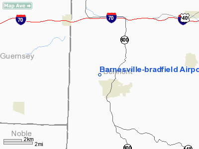
Barnesville-bradfield Airport |
Location & QuickFacts
| FAA Information Effective: | 2008-09-25 |
| Airport Identifier: | 6G5 |
| Airport Status: | Operational |
| Longitude/Latitude: | 081-11-30.5680W/40-00-08.6968N
-81.191824/40.002416 (Estimated) |
| Elevation: | 1312 ft / 399.90 m (Estimated) |
| Land: | 55 acres |
| From nearest city: | 1 nautical miles NW of Barnesville, OH |
| Location: | Belmont County, OH |
| Magnetic Variation: | 08W (2000) |
Owner & Manager
| Ownership: | Publicly owned |
| Owner: | Village Of Barnesville |
| Address: | City Hall
Barnesville, OH 43713 |
| Phone number: | 740-425-1976 |
| Manager: | Clyde Wittenbrook |
| Address: | Rte 2
Barnesville, OH 43713 |
| Phone number: | 740-425-3298 |
Airport Operations and Facilities
| Airport Use: | Open to public |
| Wind indicator: | Yes |
| Segmented Circle: | No |
| Control Tower: | No |
| Lighting Schedule: | RDO-CTL
ACTVT ROTG BCN & MIRL RY 09/27 & REIL RY 27 - CTAF. |
| Beacon Color: | Clear-Green (lighted land airport) |
| Landing fee charge: | No |
| Sectional chart: | Detroit |
| Region: | AGL - Great Lakes |
| Boundary ARTCC: | ZOB - Cleveland |
| Tie-in FSS: | CLE - Cleveland |
| FSS on Airport: | No |
| FSS Toll Free: | 1-800-WX-BRIEF |
| NOTAMs Facility: | CLE (NOTAM-d service avaliable) |
| Federal Agreements: | N |
Airport Communications
| CTAF: | 123.000 |
| Unicom: | 123.000 |
Airport Services
| Fuel available: | 100LLA |
| Airframe Repair: | MAJOR |
| Power Plant Repair: | MAJOR |
Runway Information
Runway 09/27
| Dimension: | 4004 x 65 ft / 1220.4 x 19.8 m |
| Surface: | ASPH, Good Condition |
| Weight Limit: | Single wheel: 30000 lbs. |
| Edge Lights: | Medium |
| |
Runway 09 |
Runway 27 |
| Longitude: | 081-11-56.2390W | 081-11-04.8968W |
| Latitude: | 40-00-07.4545N | 40-00-09.9375N |
| Elevation: | 1309.00 ft | 1312.00 ft |
| Alignment: | 86 | 127 |
| Traffic Pattern: | Left | Left |
| Markings: | Non-precision instrument, Good Condition | Non-precision instrument, Good Condition |
| Displaced threshold: | 299.00 ft | 0.00 ft |
| Runway End Identifier: | No | Yes |
| Centerline Lights: | No | No |
| Touchdown Lights: | No | No |
| Obstruction: | 15 ft road, 201.0 ft from runway, 111 ft right of centerline
APCH SLOPE 0:1 TO DSPLCD THLD DUE TO +15 FT ROAD 200 FT FROM 143 FT L.
+15 FT ROAD 0 FT FM RY END 94 FT L TO 200 FT FM 137 FT R. | 34 ft trees, 201.0 ft from runway, 240 ft right of centerline
+30 FT TREES 0-200 FT FROM THLD 250 FT R. |
|
Radio Navigation Aids
| ID |
Type |
Name |
Ch |
Freq |
Var |
Dist |
| PKB | FAN MARKER | Marietta Ohio | | | 03W | 38.5 nm |
| CFX | NDB | Cadiz | | 239.00 | 07W | 16.3 nm |
| HRA | NDB | Zanesville | | 204.00 | 06W | 34.0 nm |
| TSO | NDB | Tolson | | 395.00 | 07W | 34.1 nm |
| MLR | NDB | Millersburg/dcmsnd | | 382.00 | 06W | 45.0 nm |
| PNU | NDB | Washington County | | 255.00 | 08W | 48.1 nm |
| AIR | VOR/DME | Bellaire | 118X | 117.10 | 07W | 17.3 nm |
| CTW | VOR/DME | Newcomerstown | 055X | 111.80 | 07W | 18.9 nm |
| ZZV | VOR/DME | Zanesville | 051X | 111.40 | 06W | 32.5 nm |
| HLG | VOR/DME | Wheeling | 059X | 112.20 | 07W | 32.6 nm |
| BSV | VOR/DME | Briggs | 071X | 112.40 | 04W | 45.7 nm |
| JPU | VORTAC | Parkersburg | 023X | 108.60 | 03W | 34.8 nm |
Remarks
- DEER & OTHER WILDLIFE ON & INVOF ARPT.
Images and information placed above are from
http://www.airport-data.com/airport/6G5/
We thank them for the data!
|
|


