 |
|
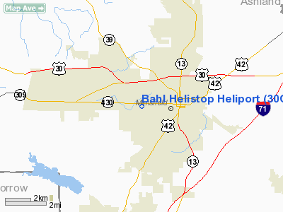
Location & QuickFacts
| FAA Information Effective: | 2008-09-25 |
| Airport Identifier: | 30OH |
| Airport Status: | Operational |
| Longitude/Latitude: | 082-33-00.6140W/40-45-25.2040N
-82.550171/40.757001 (Estimated) |
| Elevation: | 1345 ft / 409.96 m (Estimated) |
| Land: | 0 acres |
| From nearest city: | 2 nautical miles W of Mansfield, OH |
| Location: | Richland County, OH |
| Magnetic Variation: | 06W (1985) |
Owner & Manager
| Ownership: | Privately owned |
| Owner: | Bill Bahl |
| Address: | 961 Park Ave West
Mansfield, OH 44906 |
| Phone number: | 419-755-0524 |
| Manager: | Bill Bahl |
| Address: | 961 Park Ave. West
Mansfield, OH 44906 |
| Phone number: | 419-755-0524 |
Airport Operations and Facilities
| Airport Use: | Private
PERSONAL USE. |
| Wind indicator: | No |
| Segmented Circle: | No |
| Control Tower: | No |
| Sectional chart: | Detroit |
| Region: | AGL - Great Lakes |
| Boundary ARTCC: | ZOB - Cleveland |
| Tie-in FSS: | CLE - Cleveland |
| FSS on Airport: | No |
| FSS Toll Free: | 1-800-WX-BRIEF |
Airport Services
| Airframe Repair: | NONE |
| Power Plant Repair: | NONE |
Runway Information
Helipad H1
| Dimension: | 200 x 200 ft / 61.0 x 61.0 m |
| Surface: | ASPH, |
| |
Runway H1 |
Runway |
| Traffic Pattern: | Left | Left |
|
Radio Navigation Aids
| ID |
Type |
Name |
Ch |
Freq |
Var |
Dist |
| MF | NDB | Manns | | 372.00 | 06W | 4.8 nm |
| AAU | NDB | Ashland | | 329.00 | 07W | 18.3 nm |
| MNN | NDB | Marion | | 201.00 | 05W | 25.1 nm |
| MLR | NDB | Millersburg/dcmsnd | | 382.00 | 06W | 33.5 nm |
| TII | NDB | Tiffin | | 269.00 | 05W | 36.2 nm |
| DLZ | NDB | Delaware | | 215.00 | 06W | 38.4 nm |
| CL | NDB | Harri | | 344.00 | 07W | 43.9 nm |
| HEH | NDB | Newark | | 524.00 | 06W | 44.1 nm |
| FZI | NDB | Fostoria | | 379.00 | 05W | 46.4 nm |
| CM | NDB | Sumie | | 391.00 | 05W | 47.3 nm |
| DKG | NDB | Don Scott | | 348.00 | 05W | 47.3 nm |
| PCW | NDB | Port Clinton | | 423.00 | 06W | 48.0 nm |
| MRT | NDB | Marysville | | 403.00 | 05W | 48.5 nm |
| CHC | NDB | Grens | | 272.00 | 04W | 50.0 nm |
| BUD | VOR | Buckeye | | 109.80 | 05W | 24.9 nm |
| TVT | VOR/DME | Tiverton | 112X | 116.50 | 03W | 26.4 nm |
| DJB | VOR/DME | Dryer | 083X | 113.60 | 05W | 40.2 nm |
| SKY | VOR/DME | Sandusky | 029X | 109.20 | 04W | 41.0 nm |
| MFD | VORTAC | Mansfield | 025X | 108.80 | 03W | 7.0 nm |
| APE | VORTAC | Appleton | 114X | 116.70 | 06W | 36.5 nm |
| CMH | VOT | Port Columbus | | 111.00 | | 48.3 nm |
Remarks
- PROVIDED ALL APPROACH/DEPARTURE ROUTE HELICOPTER OPERATIONS ARE FROM 70 DEGREES CLOCKWISE TO 290 DEGREES USING THE TOUCHDOWN PAD AS THE CENTER OF A COMPASS ROSE; ALL APPROACHES ARE MADE WITH NO LESS THAN A 30 DEGREE APPROACH SLOPE.
Images and information placed above are from
http://www.airport-data.com/airport/30OH/
We thank them for the data!
| General Info
|
| Country |
United States
|
| State |
OHIO
|
| FAA ID |
30OH
|
| Latitude |
40-45-25.204N
|
| Longitude |
082-33-00.614W
|
| Elevation |
1345 feet
|
| Near City |
MANSFIELD
|
We don't guarantee the information is fresh and accurate. The data may
be wrong or outdated.
For more up-to-date information please refer to other sources.
|
|


