 |
|
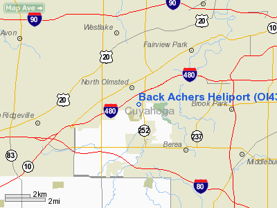
Location & QuickFacts
| FAA Information Effective: | 2008-09-25 |
| Airport Identifier: | OI43 |
| Airport Status: | Operational |
| Longitude/Latitude: | 081-54-29.4980W/41-24-12.1720N
-81.908194/41.403381 (Estimated) |
| Elevation: | 760 ft / 231.65 m (Estimated) |
| Land: | 0 acres |
| From nearest city: | 0 nautical miles of North Olmsted, OH |
| Location: | Cuyahoga County, OH |
| Magnetic Variation: | 06W (1985) |
Owner & Manager
| Ownership: | Privately owned |
| Owner: | C. C. Crabs |
| Address: | 25575 Butternut Ridge Rd
North Olmsted, OH 44070-4505 |
| Manager: | C. C. Crabs |
| Address: | 25575 Butternut Ridge Rd
North Olmsted, OH 44070-4505 |
Airport Operations and Facilities
| Airport Use: | Private
PERSONAL USE. |
| Wind indicator: | Yes |
| Segmented Circle: | No |
| Control Tower: | No |
| Sectional chart: | Detroit |
| Region: | AGL - Great Lakes |
| Boundary ARTCC: | ZOB - Cleveland |
| Tie-in FSS: | CLE - Cleveland |
| FSS on Airport: | No |
| FSS Toll Free: | 1-800-WX-BRIEF |
Runway Information
Helipad H1
| Dimension: | 400 x 100 ft / 121.9 x 30.5 m |
| Surface: | TURF, |
| |
Runway H1 |
Runway |
| Traffic Pattern: | Left | Left |
|
Radio Navigation Aids
| ID |
Type |
Name |
Ch |
Freq |
Var |
Dist |
| CL | NDB | Harri | | 344.00 | 07W | 4.6 nm |
| EZE | NDB | Engel | | 226.00 | 07W | 9.8 nm |
| BKL | NDB | Burke Lakefront | | 416.00 | 07W | 13.4 nm |
| LQL | NDB | Lakeland | | 263.00 | 08W | 29.1 nm |
| AAU | NDB | Ashland | | 329.00 | 07W | 30.7 nm |
| AK | NDB | Akron | | 362.00 | 07W | 30.9 nm |
| PT | NDB | Pelee Island | | 283.00 | 05W | 41.0 nm |
| PCW | NDB | Port Clinton | | 423.00 | 06W | 43.8 nm |
| MF | NDB | Manns | | 372.00 | 06W | 45.4 nm |
| DJB | VOR/DME | Dryer | 083X | 113.60 | 05W | 11.8 nm |
| LNN | VOR/DME | Lost Nation | 039X | 110.20 | 08W | 28.8 nm |
| SKY | VOR/DME | Sandusky | 029X | 109.20 | 04W | 33.7 nm |
| CXR | VOR/DME | Chardon | 074X | 112.70 | 05W | 34.2 nm |
| ACO | VOR/DME | Akron | 091X | 114.40 | 04W | 36.5 nm |
| BSV | VOR/DME | Briggs | 071X | 112.40 | 04W | 45.3 nm |
| MFD | VORTAC | Mansfield | 025X | 108.80 | 03W | 44.6 nm |
| CLE | VOT | Cleveland | | 110.40 | | 2.7 nm |
| CAK | VOT | Akron/canton Regional | | 110.60 | | 36.1 nm |
Remarks
- OWNER DESIRES ARPT NOT BE CHARTED.
- (E111-2) ALL INGRESS/EGRESS OPNS TO/FROM THE HELIPAD OTHER THAN THOSE IN THE IMMEDIATE AREA ARE FLOWN AS DIRECTED BY THE CLEVELAND HOPKINS FAA ATCT.
- (E111-3) THE TAKEOFF/LANDING AREA IS APPROPRIATELY MARKED AND A NON-OBSTRUCTING WIND INDICATOR IS MAINTAINED ADJACENT TO THE TAKEOFF/LANDING AREA.
- (E111-4) ALL OPERATIONS CONDUCTED IN ACCORDANCE WITH FAR 91; HELIPAD RESTRICTED TO PERSONAL USE; 2-WAY RADIO COMM WITH CLE ATCT PRIOR TO LIFT-OFF.
- PROVIDED ALL LIFT-OFF INGRESS/EGRESS OPNS TO/FROM THE HELIPAD ARE CONDUCTED IN AN AREA FROM 045 DEG CLOCKWISE TO 225 DEG USING THE TOUCHDOWN PAD;. AS THE CENTER OF A COMPASS ROSE; THIS ROUTE SHALL BE USED ONLY TO CLEAR STRUCTURES IN THE IMMEDIATE AREA OF THE HELIPAD.
Images and information placed above are from
http://www.airport-data.com/airport/OI43/
We thank them for the data!
| General Info
|
| Country |
United States
|
| State |
OHIO
|
| FAA ID |
OI43
|
| Latitude |
41-24-12.172N
|
| Longitude |
081-54-29.498W
|
| Elevation |
760 feet
|
| Near City |
NORTH OLMSTED
|
We don't guarantee the information is fresh and accurate. The data may
be wrong or outdated.
For more up-to-date information please refer to other sources.
|
|


