 |
|
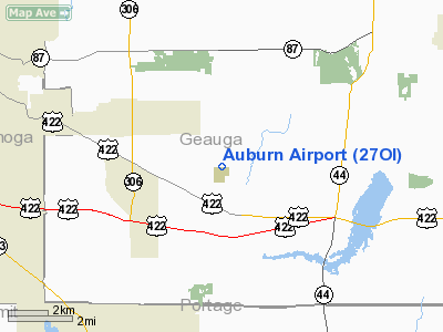
Location & QuickFacts
| FAA Information Effective: | 2008-09-25 |
| Airport Identifier: | 27OI |
| Airport Status: | Operational |
| Longitude/Latitude: | 081-17-03.3790W/41-24-37.1910N
-81.284272/41.410331 (Estimated) |
| Elevation: | 1200 ft / 365.76 m (Estimated) |
| Land: | 100 acres |
| From nearest city: | 5 nautical miles E of Chagrin Falls, OH |
| Location: | Geauga County, OH |
| Magnetic Variation: | 07W (1985) |
Owner & Manager
| Ownership: | Privately owned |
| Owner: | Ernie Mizda |
| Address: | 10001 Stafford Rd
Chagrin Falls, OH 44022 |
| Phone number: | 216-543-4448 |
| Manager: | Louis A Goldbach |
| Address: | 15221 Hemlock Pt Rd
Chagrin Falls, OH 44022 |
| Phone number: | 216-338-6891 |
Airport Operations and Facilities
| Airport Use: | Private |
| Wind indicator: | Yes |
| Segmented Circle: | No |
| Control Tower: | No |
| Lighting Schedule: | PHONE REQ
FOR LIRL 15/33 & ROTG BCN CALL 216-543-4448. |
| Beacon Color: | Clear (unlighted land airport) |
| Sectional chart: | Detroit |
| Region: | AGL - Great Lakes |
| Boundary ARTCC: | ZOB - Cleveland |
| Tie-in FSS: | CLE - Cleveland |
| FSS on Airport: | No |
| FSS Toll Free: | 1-800-WX-BRIEF |
Runway Information
Runway 09/27
| Dimension: | 1836 x 65 ft / 559.6 x 19.8 m |
| Surface: | TURF, |
| |
Runway 09 |
Runway 27 |
| Traffic Pattern: | Left | Left |
|
Runway 15/33
| Dimension: | 2800 x 75 ft / 853.4 x 22.9 m |
| Surface: | TURF, |
| Edge Lights: | Low |
| |
Runway 15 |
Runway 33 |
| Traffic Pattern: | Left | Right |
| Obstruction: | 60 ft trees, 200.0 ft from runway | 30 ft pline, 50.0 ft from runway |
|
Radio Navigation Aids
| ID |
Type |
Name |
Ch |
Freq |
Var |
Dist |
| LQL | NDB | Lakeland | | 263.00 | 08W | 16.9 nm |
| BKL | NDB | Burke Lakefront | | 416.00 | 07W | 18.5 nm |
| EZE | NDB | Engel | | 226.00 | 07W | 20.3 nm |
| AK | NDB | Akron | | 362.00 | 07W | 21.0 nm |
| CL | NDB | Harri | | 344.00 | 07W | 31.0 nm |
| HBD | NDB | Hubbard | | 408.00 | 08W | 37.4 nm |
| UCP | NDB | Castle | | 272.00 | 09W | 45.6 nm |
| CXR | VOR/DME | Chardon | 074X | 112.70 | 05W | 8.4 nm |
| LNN | VOR/DME | Lost Nation | 039X | 110.20 | 08W | 17.1 nm |
| ACO | VOR/DME | Akron | 091X | 114.40 | 04W | 18.6 nm |
| JFN | VOR/DME | Jefferson | 099X | 115.20 | 05W | 32.0 nm |
| DJB | VOR/DME | Dryer | 083X | 113.60 | 05W | 39.7 nm |
| BSV | VOR/DME | Briggs | 071X | 112.40 | 04W | 40.8 nm |
| YNG | VORTAC | Youngstown | 027X | 109.00 | 05W | 27.9 nm |
| CLE | VOT | Cleveland | | 110.40 | | 25.4 nm |
| CAK | VOT | Akron/canton Regional | | 110.60 | | 30.5 nm |
Remarks
- PRVDD OPNS ARE ON THE NE SIDE; OBSTNS ARE REMOVED OR THRS DSPLCD TO PRVD 20:1 CLRNC; PRIM SFCS ARE CLEARED.
Images and information placed above are from
http://www.airport-data.com/airport/27OI/
We thank them for the data!
| General Info
|
| Country |
United States
|
| State |
OHIO
|
| FAA ID |
27OI
|
| Latitude |
41-24-37.191N
|
| Longitude |
081-17-03.379W
|
| Elevation |
1200 feet
|
| Near City |
CHAGRIN FALLS
|
We don't guarantee the information is fresh and accurate. The data may
be wrong or outdated.
For more up-to-date information please refer to other sources.
|
|


