 |
|
| Ashtabula County Airport |
| IATA: JFN – ICAO: KHZY – FAA LID: HZY |
| Summary |
| Airport type |
Public |
| Owner |
Ashtabula County Airport Authority |
| Serves |
Ashtabula County, Ohio |
| Location |
Jefferson, Ohio |
| Elevation AMSL |
924 ft / 282 m |
| Coordinates |
41°46′41″N 080°41′44″W / 41.77806°N 80.69556°W / 41.77806; -80.69556 |
| Website |
www.khzy.biz |
| Runways |
| Direction |
Length |
Surface |
| ft |
m |
| 8/26 |
5,197 |
1,584 |
Asphalt |
| Statistics (2008) |
| Aircraft operations |
16,886 |
| Based aircraft |
44 |
| Source: Federal Aviation Administration |
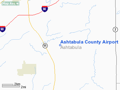
Ashtabula County Airport (IATA: JFN, ICAO: KHZY, FAA LID: HZY) is a county-owned, public-use airport in Ashtabula County, Ohio, United States, eight nautical miles (15 km) southeast of the central business district of the city of Ashtabula. The airport is located in the village of Jefferson, about 10 miles (16 km) south of Lake Erie. According to the FAA's National Plan of Integrated Airport Systems for 2009–2013, it is classified as a general aviation airport.
Although most U.S. airports use the same three-letter location identifier for the FAA and IATA, Enterprise Municipal Airport is assigned HZY by the FAA and JFN by the IATA.
Facilities and aircraft
Ashtabula County Airport covers an area of 611 acres (247 ha) at an elevation of 924 feet (282 m) above mean sea level. It has one runway designated 8/26 with an asphalt surface measuring 5,197 by 100 feet (1,584 x 30 m).
For the 12-month period ending April 23, 2008, the airport had 16,886 aircraft operations, an average of 46 per day: 95.9% general aviation, 4% air taxi, and <1% military. At that time there were 44 aircraft based at this airport: 89% single-engine, 9% multi-engine and 2% jet.
The above content comes from Wikipedia and is published under free licenses – click here to read more.
Location & QuickFacts
| FAA Information Effective: | 2008-09-25 |
| Airport Identifier: | HZY |
| Airport Status: | Operational |
| Longitude/Latitude: | 080-41-43.8286W/41-46-40.6964N
-80.695508/41.777971 (Estimated) |
| Elevation: | 924 ft / 281.64 m (Surveyed) |
| Land: | 611 acres |
| From nearest city: | 8 nautical miles SE of Ashtabula, OH |
| Location: | Ashtabula County, OH |
| Magnetic Variation: | 09W (2000) |
Owner & Manager
| Ownership: | Publicly owned |
| Owner: | Ashtabula Co Arpt Auth |
| Address: | County Courthouse
Jefferson, OH 44047 |
| Phone number: | 440-576-9271 |
| Manager: | David Price |
| Address: | 2382 Airport Road
Jefferson, OH 44047 |
| Phone number: | 440-576-9271 |
Airport Operations and Facilities
| Airport Use: | Open to public |
| Wind indicator: | Yes |
| Segmented Circle: | Yes |
| Control Tower: | No |
| Lighting Schedule: | DUSK-DAWN
ACTVT MIRL RY 08/26, PAPI RYS 08/26, REIL RYS 08 & 26 - 123.3. |
| Beacon Color: | Clear-Green (lighted land airport) |
| Landing fee charge: | No |
| Sectional chart: | Detroit |
| Region: | AGL - Great Lakes |
| Boundary ARTCC: | ZOB - Cleveland |
| Tie-in FSS: | CLE - Cleveland |
| FSS on Airport: | No |
| FSS Toll Free: | 1-800-WX-BRIEF |
| NOTAMs Facility: | HZY (NOTAM-d service avaliable) |
| Federal Agreements: | NGY |
Airport Communications
| CTAF: | 122.800 |
| Unicom: | 122.800 |
Airport Services
| Fuel available: | 100LLA1+
24 HOUR CREDIT CARD SELF SERVICE 100LL FUEL. |
| Airframe Repair: | MAJOR |
| Power Plant Repair: | MINOR |
| Bottled Oxygen: | NONE |
| Bulk Oxygen: | NONE |
Runway Information
Runway 08/26
| Dimension: | 5197 x 100 ft / 1584.0 x 30.5 m |
| Surface: | ASPH, Good Condition |
| Weight Limit: | Single wheel: 40000 lbs.
Dual wheel: 53000 lbs. |
| Edge Lights: | Medium |
| |
Runway 08 |
Runway 26 |
| Longitude: | 080-42-17.4410W | 080-41-10.2148W |
| Latitude: | 41-46-35.6191N | 41-46-45.7750N |
| Elevation: | 907.00 ft | 923.00 ft |
| Alignment: | 79 | 127 |
| Traffic Pattern: | Left | Left |
| Markings: | Non-precision instrument, Fair Condition | Non-precision instrument, Good Condition |
| Crossing Height: | 27.00 ft | 26.00 ft |
| VASI: | 4-light PAPI on left side | 4-light PAPI on left side |
| Visual Glide Angle: | 3.00° | 3.00° |
| Runway End Identifier: | Yes | Yes |
| Centerline Lights: | No | No |
| Touchdown Lights: | No | No |
| Obstruction: | 57 ft trees, 1441.0 ft from runway, 442 ft right of centerline, 21:1 slope to clear | 33 ft trees, 910.0 ft from runway, 174 ft right of centerline, 21:1 slope to clear |
|
Radio Navigation Aids
| ID |
Type |
Name |
Ch |
Freq |
Var |
Dist |
| LQL | NDB | Lakeland | | 263.00 | 08W | 31.2 nm |
| CQD | NDB | Cascade | | 372.00 | 08W | 33.4 nm |
| HBD | NDB | Hubbard | | 408.00 | 08W | 38.3 nm |
| BKL | NDB | Burke Lakefront | | 416.00 | 07W | 46.0 nm |
| UCP | NDB | Castle | | 272.00 | 09W | 47.1 nm |
| ORJ | NDB | Corry | | 258.00 | 09W | 47.6 nm |
| EZE | NDB | Engel | | 226.00 | 07W | 49.3 nm |
| FKL | VOR | Franklin | | 109.60 | 06W | 42.9 nm |
| JFN | VOR/DME | Jefferson | 099X | 115.20 | 05W | 2.6 nm |
| CXR | VOR/DME | Chardon | 074X | 112.70 | 05W | 26.2 nm |
| LNN | VOR/DME | Lost Nation | 039X | 110.20 | 08W | 31.6 nm |
| ACO | VOR/DME | Akron | 091X | 114.40 | 04W | 46.3 nm |
| ERI | VORTAC | Erie | 031X | 109.40 | 06W | 23.1 nm |
| YNG | VORTAC | Youngstown | 027X | 109.00 | 05W | 26.9 nm |
Remarks
- UNATNDD NEW YEARS DAY & CHRISTMAS DAY.
- GCO AVBL ON FREQ 121.725 THRU ERI CLEARANCE DELIVERY. CLICK 4 TIMES FOR ERI TOWER AND 6 TIMES FOR CLEVELAND FSS
- GCO OTS INDEFLY.
Images and information placed above are from
http://www.airport-data.com/airport/HZY/
We thank them for the data!
| General Info
|
| Country |
United States
|
| State |
OHIO
|
| FAA ID |
HZY
|
| Latitude |
41-46-40.711N
|
| Longitude |
080-41-43.848W
|
| Elevation |
924 feet
|
| Near City |
ASHTABULA
|
We don't guarantee the information is fresh and accurate. The data may
be wrong or outdated.
For more up-to-date information please refer to other sources.
|
|


