 |
|
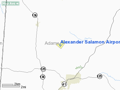
Alexander Salamon Airport |
Location & QuickFacts
| FAA Information Effective: | 2008-09-25 |
| Airport Identifier: | AMT |
| Airport Status: | Operational |
| Longitude/Latitude: | 083-33-58.5404W/38-51-05.3096N
-83.566261/38.851475 (Estimated) |
| Elevation: | 896 ft / 273.10 m (Surveyed) |
| Land: | 40 acres |
| From nearest city: | 4 nautical miles NW of West Union, OH |
| Location: | Adams County, OH |
| Magnetic Variation: | 04W (1985) |
Owner & Manager
| Ownership: | Publicly owned |
| Owner: | Adams Co Arpt Auth |
| Address: | Adams Co. Court House
West Union, OH 45693 |
| Phone number: | 937-544-3286 |
| Manager: | Don Morrow |
| Address: | 3389 Cross Road
Winchester, OH 45697 |
| Phone number: | 937-544-5771 |
Airport Operations and Facilities
| Airport Use: | Open to public |
| Wind indicator: | Yes |
| Segmented Circle: | No |
| Control Tower: | No |
| Lighting Schedule: | DUSK-DAWN
ACTVT MIRL RY 05/23; PAPI RY 23 & REIL RY 23 - CTAF. |
| Beacon Color: | Clear-Green (lighted land airport) |
| Landing fee charge: | No |
| Sectional chart: | Cincinnati |
| Region: | AGL - Great Lakes |
| Boundary ARTCC: | ZID - Indianapolis |
| Tie-in FSS: | DAY - Dayton |
| FSS on Airport: | No |
| FSS Toll Free: | 1-800-WX-BRIEF |
| NOTAMs Facility: | DAY (NOTAM-d service avaliable) |
| Federal Agreements: | N |
Airport Communications
| CTAF: | 122.800 |
| Unicom: | 122.800 |
Airport Services
| Fuel available: | 100LL80
FUEL AVBL 24 HRS-CREDIT CARD. |
| Airframe Repair: | MINOR |
| Power Plant Repair: | MINOR |
| Bottled Oxygen: | NONE |
| Bulk Oxygen: | NONE |
Runway Information
Runway 05/23
| Dimension: | 3762 x 65 ft / 1146.7 x 19.8 m |
| Surface: | ASPH, Good Condition |
| Edge Lights: | Medium |
| |
Runway 05 |
Runway 23 |
| Longitude: | 083-34-15.3950W | 083-33-41.6841W |
| Latitude: | 38-50-52.1941N | 38-51-18.4244N |
| Elevation: | 883.00 ft | 896.00 ft |
| Alignment: | 45 | 127 |
| Traffic Pattern: | Left | Left |
| Markings: | Non-precision instrument, Good Condition
MARKINGS POOR & WEATHERED. | Non-precision instrument, Good Condition |
| Crossing Height: | 0.00 ft | 30.00 ft |
| VASI: | | 4-light PAPI on left side |
| Visual Glide Angle: | 0.00° | 3.00° |
| Runway End Identifier: | | Yes |
| Obstruction: | 15 ft trees, 225.0 ft from runway, 208 ft left of centerline, 1:1 slope to clear | 91 ft trees, 1640.0 ft from runway, 420 ft left of centerline, 15:1 slope to clear |
|
Radio Navigation Aids
| ID |
Type |
Name |
Ch |
Freq |
Var |
Dist |
| AJY | FAN MARKER | Ashland | | | 03W | 40.3 nm |
| AMT | NDB | West Union | | 359.00 | 04W | 0.3 nm |
| PZO | NDB | Peebles | | 329.00 | 02W | 12.0 nm |
| XW | NDB | Flmng | | 400.00 | 05W | 17.1 nm |
| HOC | NDB | Hillsboro | | 278.00 | 05W | 20.1 nm |
| PWF | NDB | Sportys | | 245.00 | 04W | 33.2 nm |
| HW | NDB | Cubla | | 299.00 | 04W | 33.4 nm |
| PMH | NDB | Portsmouth | | 373.00 | 04W | 34.0 nm |
| EOP | NDB | Waverly | | 385.00 | 06W | 35.2 nm |
| IL | NDB | Airbo | | 407.00 | 04W | 39.3 nm |
| LUK | NDB | Cincinnati | | 335.00 | 04W | 40.7 nm |
| MDE | NDB | Madeira | | 379.00 | 04W | 43.1 nm |
| RZT | NDB | Ross County | | 236.00 | 05W | 43.3 nm |
| ISZ | NDB | Cincinnati-blue Ash | | 388.00 | 04W | 45.2 nm |
| CSS | NDB | Court House | | 414.00 | 05W | 45.8 nm |
| CYO | NDB | Circleville | | 366.00 | 05W | 48.7 nm |
| XUB | VOR | Yellow Bud | | 112.50 | 05W | 49.0 nm |
| MXQ | VOR/DME | Midwest | 076X | 112.90 | 04W | 36.4 nm |
| FLM | VOR/DME | Falmouth | 117X | 117.00 | 04W | 36.9 nm |
| YRK | VORTAC | York | 075X | 112.80 | 05W | 30.2 nm |
| LUK | VOT | Cincinnati Muni/lunken | | 108.40 | | 42.1 nm |
Remarks
- TWY LGTS OTS INDEFLY.
- VFR ONLY.
Images and information placed above are from
http://www.airport-data.com/airport/AMT/
We thank them for the data!
| General Info
|
| Country |
United States
|
| State |
OHIO
|
| FAA ID |
AMT
|
| Latitude |
38-51-05.356N
|
| Longitude |
083-33-58.600W
|
| Elevation |
896 feet
|
| Near City |
WEST UNION
|
We don't guarantee the information is fresh and accurate. The data may
be wrong or outdated.
For more up-to-date information please refer to other sources.
|
|


