 |
|
| Airborne Airpark |
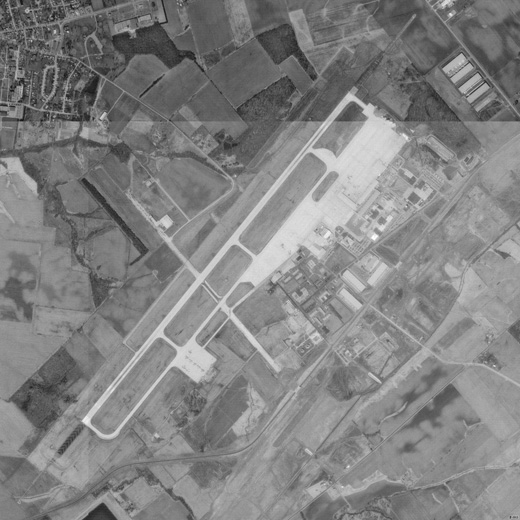 |
| USGS aerial image as of 22 March 1994 (only one runway at the time) |
| IATA: ILN – ICAO: KILN – FAA LID: ILN |
| Summary |
| Airport type |
Public |
| Owner |
DHL |
| Location |
Wilmington, Ohio |
| Elevation AMSL |
1,077 ft / 328 m |
| Coordinates |
39°25′41″N 083°47′32″W / 39.42806°N 83.79222°W / 39.42806; -83.79222 |
| Runways |
| Direction |
Length |
Surface |
| ft |
m |
| 4L/22R |
10,701 |
3,262 |
Concrete |
| 4R/22L |
9,000 |
2,743 |
Concrete |
| Statistics (2006) |
| Aircraft operations |
71,000 |
| Source: Federal Aviation Administration |
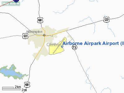
Airborne Airpark (IATA: ILN, ICAO: KILN, FAA LID: ILN) is a public-use airport located two nautical miles (3.7 km) southeast of the central business district of Wilmington, a city in Clinton County, Ohio, United States. While DHL had privately owned the property while operating from the facility, the company agreed to donate the property to the Clinton County Port Authority.
The airport was formerly known as Clinton County Air Force Base. History
The airport opened in 1929 and a small hangar was built in 1930. The landing strip was approved by the Civil Works Administration in 1933. In 1940, the Civil Aeronautics Authority took control of Wilmington Airport for use as an emergency landing field. In 1942, the Army Air Corps took over the airport, renaming it Clinton County Army Air Field. The base was decommissioned in 1972 and the Community Improvement Corporation (CIC) began developing the area as the Wilmington Industrial Air Park (WIAP). It also became home to the Great Oaks Joint Vocation School. In 1977, the Southern State Community College opened, using old barracks buildings as classrooms. In 1980, Midwest Air Charter was acquired by Airborne Freight Corporation, resulting in Airborne Express, which became the largest tenant at WIAP and resulted in the airfield being named Airborne Airpark.
In 2003, as part of the merger of DHL and Airborne, DHL kept Airborne's ground operations and spun off its air operations as ABX Air. The facility, sometimes referred to as ABX Airpark, was a major sorting center for package delivery service DHL Express between 2005 and the sorting center's closing in July, 2009, following then Deutsche Post-owned DHL's cessation of US domestic delivery services.
Facilities and aircraft
Airborne Airpark covers an area of 2,000 acres (809 ha) at an elevation of 1,077 feet (328 m) above mean sea level. It has two concrete surfaced runways: 4L/22R is 10,701 by 150 feet (3,262 x 46 m) and 4R/22L is 9,000 by 150 feet (2,743 x 46 m).
For the 12-month period ending December 31, 2006, the airport had 71,000 aircraft operations, an average of 194 per day: 96% scheduled commercial and 4% general aviation.
Future of the Property
On January 19, 2010, DHL agreed to turn over the airport, including its two runways, control tower, buildings and cargo storage facilities to the Clinton County Port Authority. While no concrete plans have been set, the port authority plans to work with local and state officials on redeveloping the property.
The above content comes from Wikipedia and is published under free licenses – click here to read more.
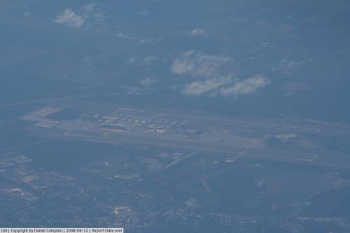 |
(Click on the photo to enlarge) |
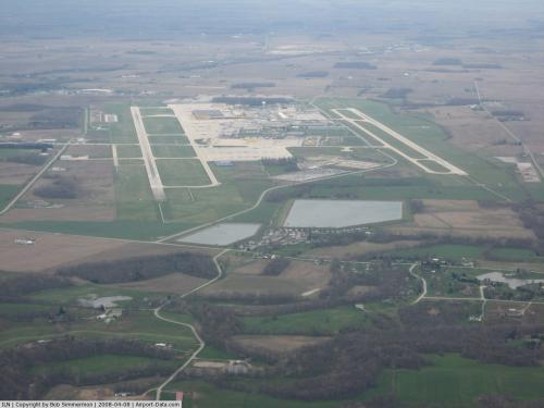 |
(Click on the photo to enlarge) |
Location & QuickFacts
| FAA Information Effective: | 2008-09-25 |
| Airport Identifier: | ILN |
| Airport Status: | Operational |
| Longitude/Latitude: | 083-47-31.6278W/39-25-40.5107N
-83.792119/39.427920 (Estimated) |
| Elevation: | 1077 ft / 328.27 m (Surveyed) |
| Land: | 2000 acres |
| From nearest city: | 2 nautical miles SE of Wilmington, OH |
| Location: | Clinton County, OH |
| Magnetic Variation: | 04W (1985) |
Owner & Manager
| Ownership: | Privately owned |
| Owner: | Dhl |
| Address: | 145 Hunter Dr
Wilmington, OH 45177 |
| Phone number: | 937-382-5591 |
| Manager: | Paul Bobay |
| Address: | 145 Hunter Dr
Wilmington, OH 45177 |
| Phone number: | 937-382-5591
EXT 2960. |
Airport Operations and Facilities
| Airport Use: | Open to public |
| Wind indicator: | Yes |
| Segmented Circle: | No |
| Control Tower: | Yes |
| Lighting Schedule: | 0000-0700
FOR HIRL RYS 04L/22R & 04R/22L WHEN ATCT CLSDCONTACT OPNS ON 119.47. |
| Beacon Color: | Clear-Green (lighted land airport) |
| Landing fee charge: | Yes |
| Sectional chart: | Cincinnati |
| Region: | AGL - Great Lakes |
| Boundary ARTCC: | ZID - Indianapolis |
| Tie-in FSS: | DAY - Dayton |
| FSS on Airport: | No |
| FSS Toll Free: | 1-800-WX-BRIEF |
| NOTAMs Facility: | ILN (NOTAM-d service avaliable) |
| Certification type/date: | IV A U 10/197
CLSD TO SCHEDULED ACR OPNS WITH GREATER THAN 9 PSGR SEATS & UNSCHEDULED ACR OPS GREATER THAN 30 PSGR SEATS. 90-DAY PPR; CALL AMGR 937-382-5591. |
Airport Communications
Airport Services
| Fuel available: | A |
| Airframe Repair: | MAJOR |
| Power Plant Repair: | MAJOR |
| Bottled Oxygen: | NONE |
| Bulk Oxygen: | HIGH/LOW |
Runway Information
Runway 04L/22R
| Dimension: | 10701 x 150 ft / 3261.7 x 45.7 m
HAS 1000 FT PAVED AREA ON SW END AND 200 FT PAVED AREA ON NE END.
HAS 200 FT PAVED AREA EACH END. |
| Surface: | CONC, Fair Condition |
| Surface Treatment: | Saw-cut or plastic Grooved |
| Weight Limit: | Single wheel: 100000 lbs.
Dual wheel: 200000 lbs.
Dual tandem wheel: 390000 lbs.
Dual dual tandem wheel: 750000 lbs. |
| Edge Lights: | High |
| |
Runway 04L |
Runway 22R |
| Longitude: | 083-48-33.3900W | 083-47-10.7305W |
| Latitude: | 39-25-09.6843N | 39-26-33.7931N |
| Elevation: | 1053.00 ft | 1077.00 ft |
| Alignment: | 37 | 127 |
| ILS Type: | ILS
| ILS
|
| Traffic Pattern: | Left | Left |
| Markings: | Precision instrument, Good Condition | Precision instrument, Good Condition |
| Crossing Height: | 62.00 ft | 71.00 ft |
| VASI: | 4-light PAPI on left side | 4-light PAPI on left side |
| Visual Glide Angle: | 3.00° | 3.00° |
| RVR Equipment: | touchdown, midfield, rollout | touchdown, midfield, rollout |
| Approach lights: | MALSR | ALSF2 |
| Centerline Lights: | Yes | Yes |
| Touchdown Lights: | | Yes |
|
Runway 04R/22L
| Dimension: | 9000 x 150 ft / 2743.2 x 45.7 m
HAS 1000 FT PAVED AREA ON SW END AND 200 FT PAVED AREA ON NE END.
HAS 200 FT PAVED AREA EACH END. |
| Surface: | CONC, Fair Condition |
| Surface Treatment: | Saw-cut or plastic Grooved |
| Weight Limit: | Single wheel: 100000 lbs.
Dual wheel: 200000 lbs.
Dual tandem wheel: 390000 lbs.
Dual dual tandem wheel: 750000 lbs. |
| Edge Lights: | High |
| |
Runway 04R |
Runway 22L |
| Longitude: | 083-47-42.0844W | 083-46-32.5595W |
| Latitude: | 39-24-51.7884N | 39-26-02.5261N |
| Elevation: | 1043.00 ft | 1077.00 ft |
| Alignment: | 37 | 127 |
| ILS Type: | ILS/DME
| ILS/DME
|
| Traffic Pattern: | Left | Left |
| Markings: | Precision instrument, Good Condition | Precision instrument, Good Condition |
| Crossing Height: | 71.00 ft | 71.00 ft |
| VASI: | 4-light PAPI on left side | 4-light PAPI on left side |
| Visual Glide Angle: | 3.00° | 3.00° |
| RVR Equipment: | touchdown, midfield, rollout | touchdown, midfield, rollout |
| Approach lights: | MALSR | ALSF2 |
| Centerline Lights: | Yes | Yes |
| Touchdown Lights: | | Yes |
|
Radio Navigation Aids
| ID |
Type |
Name |
Ch |
Freq |
Var |
Dist |
| IL | NDB | Airbo | | 407.00 | 04W | 4.6 nm |
| HW | NDB | Cubla | | 299.00 | 04W | 5.9 nm |
| XEN | NDB | Xenia | | 395.00 | 03W | 18.4 nm |
| HOC | NDB | Hillsboro | | 278.00 | 05W | 18.7 nm |
| CSS | NDB | Court House | | 414.00 | 05W | 21.3 nm |
| CCJ | NDB | Clark County | | 341.00 | 04W | 26.8 nm |
| PWF | NDB | Sportys | | 245.00 | 04W | 28.9 nm |
| MDE | NDB | Madeira | | 379.00 | 04W | 28.9 nm |
| ISZ | NDB | Cincinnati-blue Ash | | 388.00 | 04W | 29.8 nm |
| LUK | NDB | Cincinnati | | 335.00 | 04W | 30.2 nm |
| HKF | NDB | Hook Field | | 239.00 | 04W | 30.7 nm |
| UYF | NDB | London | | 263.00 | 06W | 34.0 nm |
| RZT | NDB | Ross County | | 236.00 | 05W | 35.4 nm |
| BU | NDB | Boutn | | 230.00 | 05W | 36.0 nm |
| AMT | NDB | West Union | | 359.00 | 04W | 36.0 nm |
| HAO | NDB | Hamilton | | 260.00 | 04W | 36.4 nm |
| PZO | NDB | Peebles | | 329.00 | 02W | 37.4 nm |
| CYO | NDB | Circleville | | 366.00 | 05W | 38.1 nm |
| EOP | NDB | Waverly | | 385.00 | 06W | 43.0 nm |
| OXD | NDB | Oxford | | 282.00 | 04W | 46.1 nm |
| OS | NDB | Fuler | | 515.00 | 05W | 47.5 nm |
| CHC | NDB | Grens | | 272.00 | 04W | 49.7 nm |
| XSF | TACAN | Springfield | 065X | | 04W | 24.8 nm |
| FFO | TACAN | Patterson | 099X | | 04W | 26.5 nm |
| LCK | TACAN | Rickenbacker | 069X | | 05W | 46.0 nm |
| XUB | VOR | Yellow Bud | | 112.50 | 05W | 38.2 nm |
| MXQ | VOR/DME | Midwest | 076X | 112.90 | 04W | 0.4 nm |
| SGH | VOR/DME | Springfield | 079X | 113.20 | 04W | 24.7 nm |
| DQN | VOR/DME | Dayton | 092X | 114.50 | 01W | 45.1 nm |
| CVG | VORTAC | Cincinnati | 120X | 117.30 | 04W | 49.1 nm |
| LUK | VOT | Cincinnati Muni/lunken | | 108.40 | | 33.9 nm |
| DAY | VOT | Dayton J M Cox-day | | 111.00 | | 34.7 nm |
Remarks
- 4 HR PPR FOR ALL TRANSIENT ACFT CALL AMGR 937-382-5591 EXTN 2960 DURING OPER HRS. AFT HRS CALL FLT CTL 937-302-5591 EXT 2450
- TWY C CLSD SR-SS.
Images and information placed above are from
http://www.airport-data.com/airport/ILN/
We thank them for the data!
| General Info
|
| Country |
United States
|
| State |
OHIO
|
| FAA ID |
ILN
|
| Latitude |
39-25-40.521N
|
| Longitude |
083-47-31.631W
|
| Elevation |
1077 feet
|
| Near City |
WILMINGTON
|
We don't guarantee the information is fresh and accurate. The data may
be wrong or outdated.
For more up-to-date information please refer to other sources.
|
|


