 |
|
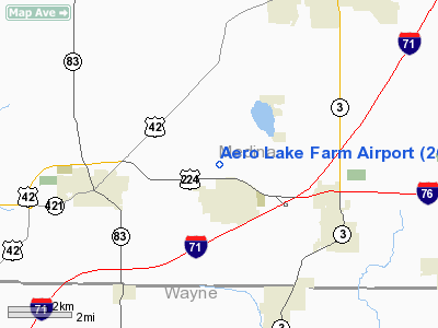
Location & QuickFacts
| FAA Information Effective: | 2008-09-25 |
| Airport Identifier: | 2OI4 |
| Airport Status: | Operational |
| Longitude/Latitude: | 081-56-11.5100W/41-02-43.1980N
-81.936531/41.045333 (Estimated) |
| Elevation: | 1195 ft / 364.24 m (Estimated) |
| Land: | 22 acres |
| From nearest city: | 1 nautical miles N of Westfield Center, OH |
| Location: | Medina County, OH |
| Magnetic Variation: | 06W (1985) |
Owner & Manager
| Ownership: | Privately owned |
| Owner: | John G. Lawton |
| Address: | 8353 Westfield Road
Seville, OH 44273 |
| Phone number: | 216-887-5453
OR 216-887-5453 |
| Manager: | John G. Lawton |
| Address: | 8353 Westfield Rd
Seville, OH 44273 |
| Phone number: | 216-887-5453 |
Airport Operations and Facilities
| Airport Use: | Private |
| Wind indicator: | Yes |
| Segmented Circle: | No |
| Control Tower: | No |
| Landing fee charge: | No |
| Sectional chart: | Detroit |
| Region: | AGL - Great Lakes |
| Boundary ARTCC: | ZOB - Cleveland |
| Tie-in FSS: | CLE - Cleveland |
| FSS on Airport: | No |
| FSS Toll Free: | 1-800-WX-BRIEF |
Runway Information
Runway 09/27
| Dimension: | 2000 x 60 ft / 609.6 x 18.3 m |
| Surface: | TURF, |
| |
Runway 09 |
Runway 27 |
| Traffic Pattern: | Left | Left |
|
Radio Navigation Aids
| ID |
Type |
Name |
Ch |
Freq |
Var |
Dist |
| AAU | NDB | Ashland | | 329.00 | 07W | 15.2 nm |
| CL | NDB | Harri | | 344.00 | 07W | 17.7 nm |
| AK | NDB | Akron | | 362.00 | 07W | 24.9 nm |
| EZE | NDB | Engel | | 226.00 | 07W | 28.4 nm |
| MF | NDB | Manns | | 372.00 | 06W | 28.6 nm |
| MLR | NDB | Millersburg/dcmsnd | | 382.00 | 06W | 30.4 nm |
| BKL | NDB | Burke Lakefront | | 416.00 | 07W | 31.6 nm |
| LQL | NDB | Lakeland | | 263.00 | 08W | 45.8 nm |
| TSO | NDB | Tolson | | 395.00 | 07W | 48.7 nm |
| DJB | VOR/DME | Dryer | 083X | 113.60 | 05W | 21.4 nm |
| BSV | VOR/DME | Briggs | 071X | 112.40 | 04W | 29.3 nm |
| ACO | VOR/DME | Akron | 091X | 114.40 | 04W | 33.5 nm |
| TVT | VOR/DME | Tiverton | 112X | 116.50 | 03W | 36.3 nm |
| SKY | VOR/DME | Sandusky | 029X | 109.20 | 04W | 40.0 nm |
| CXR | VOR/DME | Chardon | 074X | 112.70 | 05W | 45.0 nm |
| LNN | VOR/DME | Lost Nation | 039X | 110.20 | 08W | 45.7 nm |
| MFD | VORTAC | Mansfield | 025X | 108.80 | 03W | 31.5 nm |
| CLE | VOT | Cleveland | | 110.40 | | 22.3 nm |
| CAK | VOT | Akron/canton Regional | | 110.60 | | 23.7 nm |
Images and information placed above are from
http://www.airport-data.com/airport/2OI4/
We thank them for the data!
| General Info
|
| Country |
United States
|
| State |
OHIO
|
| FAA ID |
2OI4
|
| Latitude |
41-02-43.198N
|
| Longitude |
081-56-11.510W
|
| Elevation |
1195 feet
|
| Near City |
WESTFIELD CENTER
|
We don't guarantee the information is fresh and accurate. The data may
be wrong or outdated.
For more up-to-date information please refer to other sources.
|
|


