 |
|
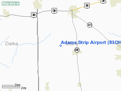
Location & QuickFacts
| FAA Information Effective: | 2008-09-25 |
| Airport Identifier: | 83OH |
| Airport Status: | Operational |
| Longitude/Latitude: | 084-22-45.8140W/40-03-44.1840N
-84.379393/40.062273 (Estimated) |
| Elevation: | 973 ft / 296.57 m (Estimated) |
| Land: | 80 acres |
| From nearest city: | 2 nautical miles NW of Pleasent Hill, OH |
| Location: | Miami County, OH |
| Magnetic Variation: | 04W (1990) |
Owner & Manager
| Ownership: | Privately owned |
| Owner: | Samuel L Adams |
| Address: | 1460 N Rangeline Rd
Pleasant Hill, OH 45359 |
| Phone number: | 513-676-3036 |
| Manager: | Dirk L Adams |
| Address: | 477 S Shilott Rd
Pleasant Hill, OH 45359 |
| Phone number: | 513-676-2739 |
Airport Operations and Facilities
| Airport Use: | Private |
| Wind indicator: | Yes |
| Segmented Circle: | No |
| Control Tower: | No |
| Sectional chart: | Detroit |
| Region: | AGL - Great Lakes |
| Boundary ARTCC: | ZID - Indianapolis |
| Tie-in FSS: | DAY - Dayton |
| FSS Toll Free: | 1-800-WX-BRIEF |
Runway Information
Runway 18/36
| Dimension: | 2400 x 60 ft / 731.5 x 18.3 m |
| Surface: | TURF, |
| |
Runway 18 |
Runway 36 |
| Traffic Pattern: | Left | Left |
| Obstruction: | 70 ft bldg, 5280.0 ft from runway | 406 ft twr, 15840.0 ft from runway |
|
Radio Navigation Aids
| ID |
Type |
Name |
Ch |
Freq |
Var |
Dist |
| VES | NDB | Versailles | | 356.00 | 04W | 10.9 nm |
| CQA | NDB | Lakefield | | 205.00 | 04W | 26.6 nm |
| XEN | NDB | Xenia | | 395.00 | 03W | 29.4 nm |
| CCJ | NDB | Clark County | | 341.00 | 04W | 29.9 nm |
| EDJ | NDB | Bellefontaine | | 242.00 | 05W | 31.9 nm |
| HKF | NDB | Hook Field | | 239.00 | 04W | 34.0 nm |
| PLD | NDB | Portland | | 257.00 | 03W | 36.4 nm |
| OXD | NDB | Oxford | | 282.00 | 04W | 38.1 nm |
| RUV | NDB | Rushsylvania | | 326.00 | 05W | 40.4 nm |
| LYL | NDB | Lima | | 362.00 | 04W | 41.9 nm |
| HAO | NDB | Hamilton | | 260.00 | 04W | 42.4 nm |
| UYF | NDB | London | | 263.00 | 06W | 42.7 nm |
| UWL | NDB | New Castle | | 385.00 | 02W | 44.6 nm |
| IL | NDB | Airbo | | 407.00 | 04W | 45.4 nm |
| MRT | NDB | Marysville | | 403.00 | 05W | 48.3 nm |
| HW | NDB | Cubla | | 299.00 | 04W | 48.6 nm |
| ISZ | NDB | Cincinnati-blue Ash | | 388.00 | 04W | 48.9 nm |
| VFU | NDB | Stanley | | 411.00 | 05W | 49.3 nm |
| FFO | TACAN | Patterson | 099X | | 04W | 20.9 nm |
| XSF | TACAN | Springfield | 065X | | 04W | 28.2 nm |
| AOH | VOR | Allen County | | 108.40 | 04W | 43.1 nm |
| DQN | VOR/DME | Dayton | 092X | 114.50 | 01W | 2.9 nm |
| SGH | VOR/DME | Springfield | 079X | 113.20 | 04W | 28.1 nm |
| MXQ | VOR/DME | Midwest | 076X | 112.90 | 04W | 46.5 nm |
| MIE | VOR/DME | Muncie | 091X | 114.40 | 03W | 47.8 nm |
| ROD | VORTAC | Rosewood | 122X | 117.50 | 05W | 20.5 nm |
| RID | VORTAC | Richmond | 043X | 110.60 | 03W | 28.1 nm |
| DAY | VOT | Dayton J M Cox-day | | 111.00 | | 12.1 nm |
Remarks
- ATC ACFT CTC DAYTON APCH PRIOR TO OPERATING IN THE TFC PAT; AREA 125' EITHER SIDE OF CNTRLN & 200' OFF RY END BE CLEAR OF OBS; OBS REMOVED/LOWERED OR THR DSPLCD & CLEARLY MKD TO PRVD 20:1 APCH SLOPE.
Images and information placed above are from
http://www.airport-data.com/airport/83OH/
We thank them for the data!
| General Info
|
| Country |
United States
|
| State |
OHIO
|
| FAA ID |
83OH
|
| Latitude |
40-03-44.184N
|
| Longitude |
084-22-45.814W
|
| Elevation |
973 feet
|
| Near City |
PLEASENT HILL
|
We don't guarantee the information is fresh and accurate. The data may
be wrong or outdated.
For more up-to-date information please refer to other sources.
|
|


