 |
|
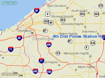
4th Dist Police Station Heliport |
Location & QuickFacts
| FAA Information Effective: | 2008-09-25 |
| Airport Identifier: | OI51 |
| Airport Status: | Operational |
| Longitude/Latitude: | 081-37-10.4560W/41-28-19.1870N
-81.619571/41.471996 (Estimated) |
| Elevation: | 825 ft / 251.46 m (Estimated) |
| Land: | 0 acres |
| From nearest city: | 0 nautical miles N of Cleveland, OH |
| Location: | Cuyahoga County, OH |
| Magnetic Variation: | 07W (1985) |
Owner & Manager
| Ownership: | Publicly owned |
| Owner: | City Of Cleveland |
| Address: | 1300 Ontario Ave
Cleveland, OH 44113 |
| Manager: | Commanding Officer |
| Address: | 9333 Kinsman Rd.
Cleveland, OH 44104 |
| Phone number: | 216-623-5400 |
Airport Operations and Facilities
| Airport Use: | Private |
| Segmented Circle: | No |
| Control Tower: | No |
| Landing fee charge: | No |
| Sectional chart: | Detroit |
| Region: | AGL - Great Lakes |
| Boundary ARTCC: | ZOB - Cleveland |
| Tie-in FSS: | CLE - Cleveland |
| FSS on Airport: | No |
| FSS Toll Free: | 1-800-WX-BRIEF |
Runway Information
Helipad H1
| Dimension: | 40 x 40 ft / 12.2 x 12.2 m |
| Surface: | CONC, |
| |
Runway H1 |
Runway |
| Traffic Pattern: | Left | Left |
|
Radio Navigation Aids
| ID |
Type |
Name |
Ch |
Freq |
Var |
Dist |
| BKL | NDB | Burke Lakefront | | 416.00 | 07W | 3.9 nm |
| EZE | NDB | Engel | | 226.00 | 07W | 4.8 nm |
| LQL | NDB | Lakeland | | 263.00 | 08W | 16.6 nm |
| CL | NDB | Harri | | 344.00 | 07W | 17.5 nm |
| AK | NDB | Akron | | 362.00 | 07W | 26.4 nm |
| AAU | NDB | Ashland | | 329.00 | 07W | 41.9 nm |
| LNN | VOR/DME | Lost Nation | 039X | 110.20 | 08W | 16.4 nm |
| CXR | VOR/DME | Chardon | 074X | 112.70 | 05W | 20.7 nm |
| DJB | VOR/DME | Dryer | 083X | 113.60 | 05W | 25.4 nm |
| ACO | VOR/DME | Akron | 091X | 114.40 | 04W | 28.9 nm |
| JFN | VOR/DME | Jefferson | 099X | 115.20 | 05W | 42.8 nm |
| BSV | VOR/DME | Briggs | 071X | 112.40 | 04W | 44.8 nm |
| SKY | VOR/DME | Sandusky | 029X | 109.20 | 04W | 46.7 nm |
| YNG | VORTAC | Youngstown | 027X | 109.00 | 05W | 43.4 nm |
| CLE | VOT | Cleveland | | 110.40 | | 11.0 nm |
| CAK | VOT | Akron/canton Regional | | 110.60 | | 34.4 nm |
Remarks
- 45' ANT 60' SE OF PAD; IN ADDITION, 14' MECH EQUIP RM 56' SW OF PAD.
- E111:VFR USE ONLY
Images and information placed above are from
http://www.airport-data.com/airport/OI51/
We thank them for the data!
| General Info
|
| Country |
United States
|
| State |
OHIO
|
| FAA ID |
OI51
|
| Latitude |
41-28-19.187N
|
| Longitude |
081-37-10.456W
|
| Elevation |
825 feet
|
| Near City |
CLEVELAND
|
We don't guarantee the information is fresh and accurate. The data may
be wrong or outdated.
For more up-to-date information please refer to other sources.
|
|


