 |
|
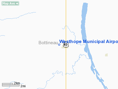
Location & QuickFacts
| FAA Information Effective: | 2008-09-25 |
| Airport Identifier: | D64 |
| Airport Status: | Operational |
| Longitude/Latitude: | 101-02-00.5640W/48-54-48.0710N
-101.033490/48.913353 (Estimated) |
| Elevation: | 1494 ft / 455.37 m (Estimated) |
| Land: | 167 acres |
| From nearest city: | 0 nautical miles W of Westhope, ND |
| Location: | Bottineau County, ND |
| Magnetic Variation: | 10E (1985) |
Owner & Manager
| Ownership: | Publicly owned |
| Owner: | Westhope Arpt Auth
CHRMN OF APT AUTH |
| Address: | Box 451
Westhope, ND 58793 |
| Phone number: | 701-245-6215 |
| Manager: | Brad Berentson |
| Address: | 90 3rd St East
Westhope, ND 58793 |
| Phone number: | 701-245-6195
ADDL PHONE FOR AMGR (701) 245-6279 OR JERRY BERENTSON (701) 245-6284/228-583. |
Airport Operations and Facilities
| Airport Use: | Open to public |
| Wind indicator: | Yes |
| Segmented Circle: | No |
| Control Tower: | No |
| Lighting Schedule: | RDO-CTL
ACTVT LIRL RY 13/31 - CTAF. |
| Landing fee charge: | No |
| Sectional chart: | Billings |
| Region: | AGL - Great Lakes |
| Boundary ARTCC: | ZMP - Minneapolis |
| Tie-in FSS: | GFK - Grand Forks |
| FSS on Airport: | No |
| FSS Toll Free: | 1-800-WX-BRIEF |
| NOTAMs Facility: | GFK (NOTAM-d service avaliable) |
| Federal Agreements: | Y1 |
Airport Communications
Airport Services
| Airframe Repair: | NONE |
| Power Plant Repair: | NONE |
| Bottled Oxygen: | NONE |
| Bulk Oxygen: | NONE |
Runway Information
Runway 13/31
| Dimension: | 3000 x 60 ft / 914.4 x 18.3 m |
| Surface: | ASPH, Fair Condition
SFC SOFT DURING SPRING FROST. |
| Weight Limit: | Single wheel: 4000 lbs. |
| Edge Lights: | Non-standard lighting system
NSTD LIRL LCTD 55' FM CNTRLN. |
| |
Runway 13 |
Runway 31 |
| Longitude: | 101-03-16.1600W | 101-02-47.5600W |
| Latitude: | 48-54-58.8900N | 48-54-36.0700N |
| Elevation: | 1492.00 ft | 1492.00 ft |
| Traffic Pattern: | Left | Left |
| Markings: | Nonstandard, Fair Condition
CENTERLINE STRIPE ONLY. | Nonstandard, Fair Condition
CENTERLINE STRIPE ONLY. |
| Obstruction: | 3 ft berm, 200.0 ft from runway, 30 ft left of centerline
+3 FT BERM AT THLD 125 FT R OF EXTDD CNTRLN; +3 FT BERM 180 FT ON EXTDD CNTRLN. | 50 ft tree, 840.0 ft from runway, 200 ft left of centerline, 12:1 slope to clear |
|
Radio Navigation Aids
| ID |
Type |
Name |
Ch |
Freq |
Var |
Dist |
| HBC | NDB | Mohall | | 350.00 | 11E | 21.8 nm |
| MIB | TACAN | Deering | 096X | | 10E | 32.7 nm |
| MOT | VORTAC | Minot | 118X | 117.10 | 13E | 40.5 nm |
Remarks
- CONFIRM SNOW REMOVAL & WINTER CONDITIONS BEFORE USE; CALL 701-245-6195/6279/6409/6571.
- -2' DITCH 65' L/R OF RY CNTRLN PARALLEL ON BOTH SIDES
- +15 FT ROAD 100 FT INBOUND RY 31 THLD XG RY ONTO TWY FOR ARPT ACCESS TO HGRS.
- RY 31 +35 FT PLINE 800 FT FROM THLD 175 FT LEFT, APCH RATIO 17:1; +30 FT POLE 800 FT FROM THLD 175 FT RIGHT, APCH RATIO 20:1.
- MIGRATORY BIRDS ON OR NEAR VICINITY OF AIRPORT
Images and information placed above are from
http://www.airport-data.com/airport/D64/
We thank them for the data!
|
|


