 |
|
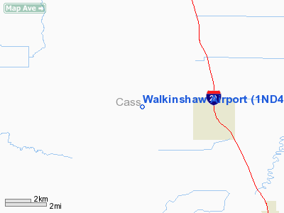
Location & QuickFacts
| FAA Information Effective: | 2008-09-25 |
| Airport Identifier: | 1ND4 |
| Airport Status: | Operational |
| Longitude/Latitude: | 097-01-01.3060W/47-03-29.9020N
-97.017029/47.058306 (Estimated) |
| Elevation: | 900 ft / 274.32 m (Estimated) |
| Land: | 320 acres |
| From nearest city: | 3 nautical miles W of Argusville, ND |
| Location: | Cass County, ND |
| Magnetic Variation: | 06E (1985) |
Owner & Manager
| Ownership: | Privately owned |
| Owner: | Warren V. Walkinshaw |
| Address: | Box 35
Argusville, ND 58005 |
| Phone number: | 701-484-5512 |
| Manager: | Warren V. Walkinshaw |
| Address: | 2346 164th Ave Se
Argusville, ND 58005 |
| Phone number: | 701-484-5520 |
Airport Operations and Facilities
| Airport Use: | Private |
| Wind indicator: | Yes |
| Segmented Circle: | No |
| Control Tower: | No |
| Landing fee charge: | No |
| Sectional chart: | Twin Cities |
| Region: | AGL - Great Lakes |
| Boundary ARTCC: | ZMP - Minneapolis |
| Tie-in FSS: | GFK - Grand Forks |
| FSS on Airport: | No |
| FSS Toll Free: | 1-800-WX-BRIEF |
Airport Services
Runway Information
Runway 08/26
| Dimension: | 1500 x 60 ft / 457.2 x 18.3 m |
| Surface: | TURF, Fair Condition |
| |
Runway 08 |
Runway 26 |
| Traffic Pattern: | Left | Left |
| Obstruction: | 2 ft road, 50 ft left of centerline, 1:1 slope to clear | 40 ft trees, 100.0 ft from runway, 2:1 slope to clear |
|
Runway 17/35
| Dimension: | 2500 x 150 ft / 762.0 x 45.7 m |
| Surface: | TURF, Fair Condition |
| |
Runway 17 |
Runway 35 |
| Traffic Pattern: | Left | Left |
| Obstruction: | 3 ft road, 30.0 ft from runway, 1:1 slope to clear | 60 ft trees, 0.0 ft from runway, 100 ft right of centerline, 1:1 slope to clear
+60'TREES PARELLEL & 100'R OF THR PENT 7:1 LATERAL CLNC. |
|
Radio Navigation Aids
| ID |
Type |
Name |
Ch |
Freq |
Var |
Dist |
| AA | NDB | Kenie | | 365.00 | 06E | 8.8 nm |
| VCY | NDB | Valley City | | 382.00 | 07E | 38.4 nm |
| CKN | NDB | Crookston | | 400.00 | 07E | 49.7 nm |
| DTL | VOR/DME | Detroit Lakes | 049X | 111.20 | 05E | 48.4 nm |
| FAR | VORTAC | Fargo | 109X | 116.20 | 09E | 19.6 nm |
Remarks
- EXTSV AERIAL ACTVTY ON ARPT MAY-SEP.
- RWY 17/35 SOUTH OF FARMSTEAD CLSD.
- WIP ON NEW 5000'RWY PARALLEL TO PRESENT 17/35. AFTER HVY RAINS BOTH RWY 8/26 & 17/35 SOFT.
Images and information placed above are from
http://www.airport-data.com/airport/1ND4/
We thank them for the data!
|
|


