 |
|
| Robertson Field |
| IATA: none – ICAO: none – FAA LID: D55 |
| Summary |
| Airport type |
Public |
| Owner |
Langdon Airport Authority |
| Location |
Langdon, North Dakota |
| Elevation AMSL |
1,608 ft / 490 m |
| Coordinates |
48°45′11″N 098°23′36″W / 48.75306°N 98.39333°W / 48.75306; -98.39333 |
| Runways |
| Direction |
Length |
Surface |
| ft |
m |
| 14/32 |
3,600 |
1,097 |
Asphalt |
| 8/26 |
2,400 |
732 |
Turf |
| Statistics (1997) |
| Aircraft operations |
1,900 |
| Source: Federal Aviation Administration |
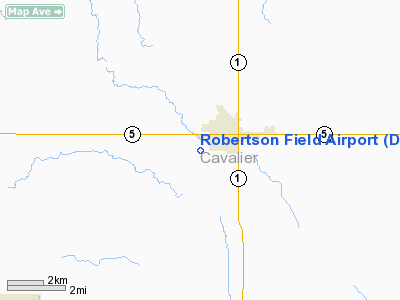
Robertson Field (FAA LID: D55) is a public airport located one mile (2 km) west of the central business district of Langdon, in Cavalier County, North Dakota, United States. It is owned by the Langdon Airport Authority.
Facilities and aircraft
Robertson Field covers an area of 100 acres (40 ha) which contains two runways:
- Runway 14/32: 3,600 x 60 ft (1,097 x 18 m), Surface: Asphalt
- Runway 8/26: 2,400 x 150 ft (732 x 46 m), Surface: Turf
For the 12-month period ending November 26, 1997, the airport had 1,900 aircraft operations: 89% general aviation and 11% air taxi.
The above content comes from Wikipedia and is published under free licenses – click here to read more.
Location & QuickFacts
| FAA Information Effective: | 2008-09-25 |
| Airport Identifier: | D55 |
| Airport Status: | Operational |
| Longitude/Latitude: | 098-23-37.3000W/48-45-11.3000N
-98.393694/48.753139 (Estimated) |
| Elevation: | 1608 ft / 490.12 m (Surveyed) |
| Land: | 100 acres |
| From nearest city: | 1 nautical miles W of Langdon, ND |
| Location: | Cavalier County, ND |
| Magnetic Variation: | 07E (1985) |
Owner & Manager
| Ownership: | Publicly owned |
| Owner: | Langdon Arpt Authority
CHRMN OF ARPT AUTH - JOHN BOE |
| Address: | 1310 12th St
Langdon, ND 58249 |
| Phone number: | 701-256-3776
OWNER CELL PHONE 701-370-2076 |
| Manager: | Rick Ring
ADDNL CTC JOHN BOE (701) 256-3776/3639. |
| Address: | Box 346
Langdon, ND 58249 |
| Phone number: | 701-256-5900
AMGR PHONE 701-256-3259 OR CELL 370-2003 AFT HRS. |
Airport Operations and Facilities
| Airport Use: | Open to public |
| Wind indicator: | Yes |
| Segmented Circle: | Yes |
| Control Tower: | No |
| Lighting Schedule: | DUSK-DAWN
ACTVT MIRL RY 14/32 - CTAF. |
| Beacon Color: | Clear-Green (lighted land airport) |
| Landing fee charge: | No |
| Sectional chart: | Twin Cities |
| Region: | AGL - Great Lakes |
| Boundary ARTCC: | ZMP - Minneapolis |
| Tie-in FSS: | GFK - Grand Forks |
| FSS on Airport: | No |
| FSS Toll Free: | 1-800-WX-BRIEF |
| NOTAMs Facility: | GFK (NOTAM-d service avaliable) |
| Federal Agreements: | NGY |
Airport Communications
| CTAF: | 122.800 |
| Unicom: | 122.800 |
Airport Services
| Fuel available: | 100LL
FOR FUEL CTC AMGR ON 701-256-5900/3259 OR 701-3776/3639/2166. |
| Airframe Repair: | NONE |
| Power Plant Repair: | NONE |
| Bottled Oxygen: | NONE |
| Bulk Oxygen: | NONE |
Runway Information
Runway 08/26
| Dimension: | 2010 x 100 ft / 612.6 x 30.5 m |
| Surface: | TURF, Fair Condition |
| |
Runway 08 |
Runway 26 |
| Longitude: | 098-23-46.7147W | 098-23-16.7202W |
| Latitude: | 48-45-15.4561N | 48-45-15.4777N |
| Elevation: | 1600.00 ft | 1601.00 ft |
| Traffic Pattern: | Left | Left |
| Markings: | None, | None, |
| Runway End Identifier: | No | No |
| Centerline Lights: | No | No |
| Touchdown Lights: | No | No |
| Obstruction: | , 50:1 slope to clear | 10 ft road, 175.0 ft from runway, 17:1 slope to clear |
|
Runway 14/32
| Dimension: | 3600 x 60 ft / 1097.3 x 18.3 m |
| Surface: | ASPH, Good Condition |
| Weight Limit: | Single wheel: 12500 lbs. |
| Edge Lights: | Medium |
| |
Runway 14 |
Runway 32 |
| Longitude: | 098-23-57.7567W | 098-23-23.0288W |
| Latitude: | 48-45-22.5682N | 48-44-55.4672N |
| Elevation: | 1603.00 ft | 1608.00 ft |
| Alignment: | 127 | 127 |
| Traffic Pattern: | Left | Left |
| Markings: | Non-precision instrument, Good Condition | Non-precision instrument, Good Condition |
| Crossing Height: | 25.00 ft | 25.00 ft |
| VASI: | 2-light PAPI on left side | 2-light PAPI on left side |
| Visual Glide Angle: | 3.00° | 3.00° |
| Obstruction: | 60 ft trees, 2100.0 ft from runway, 275 ft right of centerline, 31:1 slope to clear | 18 ft road, 750.0 ft from runway, 180 ft right of centerline, 30:1 slope to clear |
|
Radio Navigation Aids
| ID |
Type |
Name |
Ch |
Freq |
Var |
Dist |
| RLL | NDB | Rolla | | 263.00 | 09E | 48.9 nm |
| DVL | VOR/DME | Devils Lake | 047X | 111.00 | 07E | 43.6 nm |
Remarks
- RY 08/26 CLOSED WINTERS DUE TO LACK OF SNOW REMOVAL.
- LARGE BIRDS ON & INVOF ARPT APR-NOV.
- MIDFIELD N/S TWY HAS REFLECTORS; SFC COND POOR.
- CONFIRM WINTER CONDS/SNOW REMOVAL WITH AMGR AT 701-256-5900/3259/3776/3639.
- NOISE SENSITIVE AREA NW QUADRANT OF FIELD; AVOID OVERFLIGHT.
Images and information placed above are from
http://www.airport-data.com/airport/D55/
We thank them for the data!
| General Info
|
| Country |
United States
|
| State |
NORTH DAKOTA
|
| FAA ID |
D55
|
| Latitude |
48-45-10.864N
|
| Longitude |
098-23-36.013W
|
| Elevation |
1608 feet
|
| Near City |
LANGDON
|
We don't guarantee the information is fresh and accurate. The data may
be wrong or outdated.
For more up-to-date information please refer to other sources.
|
|


