 |
|
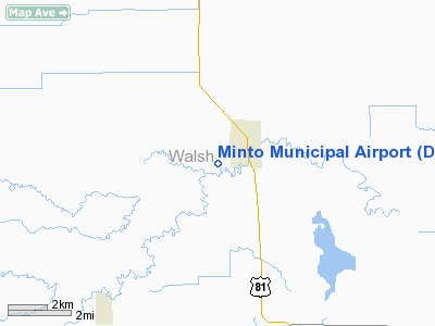
Location & QuickFacts
| FAA Information Effective: | 2008-09-25 |
| Airport Identifier: | D06 |
| Airport Status: | Operational |
| Longitude/Latitude: | 097-23-31.2760W/48-16-59.9570N
-97.392021/48.283321 (Estimated) |
| Elevation: | 820 ft / 249.94 m (Estimated) |
| Land: | 10 acres |
| From nearest city: | 1 nautical miles W of Minto, ND |
| Location: | Walsh County, ND |
| Magnetic Variation: | 06E (1985) |
Owner & Manager
| Ownership: | Privately owned |
| Owner: | Minto Arpt Auth |
| Address: | Po Box 383
Minto, ND 58261 |
| Phone number: | 701-248-3224 |
| Manager: | Brad Guadry |
| Address: | Box 383
Minto, ND 58261 |
| Phone number: | 701-248-3224
BRAD GAUDRY CELL PHONE 218-779-7940 |
Airport Operations and Facilities
| Airport Use: | Open to public |
| Wind indicator: | Yes |
| Segmented Circle: | No |
| Control Tower: | No |
| Landing fee charge: | No |
| Sectional chart: | Twin Cities |
| Region: | AGL - Great Lakes |
| Boundary ARTCC: | ZMP - Minneapolis |
| Tie-in FSS: | GFK - Grand Forks |
| FSS on Airport: | No |
| FSS Toll Free: | 1-800-WX-BRIEF |
| NOTAMs Facility: | GFK (NOTAM-d service avaliable) |
Airport Communications
Airport Services
| Airframe Repair: | NONE |
| Power Plant Repair: | NONE |
| Bottled Oxygen: | NONE |
| Bulk Oxygen: | NONE |
Runway Information
Runway 17/35
| Dimension: | 2600 x 100 ft / 792.5 x 30.5 m |
| Surface: | CONC-TURF, Fair Condition
CONC SFC 2300 FT BY 20 FT IN CENTER LCTD 300 FT INBOUND N END; TURF SFC SOFT WHEN WET; SPARSE GRASS BORDERING CONCRETE EDGES. |
| |
Runway 17 |
Runway 35 |
| Longitude: | 097-23-38.7800W | 097-23-38.7800W |
| Latitude: | 48-17-46.4600N | 48-17-20.8000N |
| Elevation: | 825.00 ft | 818.00 ft |
| Traffic Pattern: | Left | Left |
| Obstruction: | 17 ft road, 20.0 ft from runway, 1:1 slope to clear | 60 ft pline, 2600.0 ft from runway, 43:1 slope to clear |
|
Radio Navigation Aids
| ID |
Type |
Name |
Ch |
Freq |
Var |
Dist |
| CKN | NDB | Crookston | | 400.00 | 07E | 41.0 nm |
| RDR | TACAN | Red River | 111X | | 06E | 19.6 nm |
| GFK | VOR/DME | Grand Forks | 090X | 114.30 | 09E | 21.4 nm |
| HML | VORTAC | Humboldt | 071X | 112.40 | 09E | 36.9 nm |
Remarks
- CONFIRM WINTER COND & SNOW REMOVAL BEFORE USE 701-248-3224/218-779-7940.
- RWY 8/26 IS PVT; NOT FOR PUBLIC USE. CTN, 80'TWR 100'FM THR RWY 26 END.
- AER 35 700' INBOARD -3' SWALE 60' L & R.
- RY 35 -5 FT DRAINAGE SWALE 50 FT FM THLD.
- ARPT CLSD IN WINTER MONTHS EXCEPT PPR CTC AMGR 701-248-3224.
Images and information placed above are from
http://www.airport-data.com/airport/D06/
We thank them for the data!
| General Info
|
| Country |
United States
|
| State |
NORTH DAKOTA
|
| FAA ID |
D06
|
| Latitude |
48-16-59.957N
|
| Longitude |
097-23-31.276W
|
| Elevation |
820 feet
|
| Near City |
MINTO
|
We don't guarantee the information is fresh and accurate. The data may
be wrong or outdated.
For more up-to-date information please refer to other sources.
|
|


