 |
|
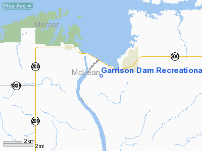
Garrison Dam Recreational Airpark Airport |
Location & QuickFacts
| FAA Information Effective: | 2008-09-25 |
| Airport Identifier: | 37N |
| Airport Status: | Operational |
| Longitude/Latitude: | 101-24-31.5780W/47-28-58.9970N
-101.408772/47.483055 (Estimated) |
| Elevation: | 1723 ft / 525.17 m (Estimated) |
| Land: | 39 acres |
| From nearest city: | 1 nautical miles SW of Riverdale, ND |
| Location: | Mc Lean County, ND |
| Magnetic Variation: | 10E (1985) |
Owner & Manager
| Ownership: | Publicly owned |
| Owner: | Us Army Corps Of Engrs
LAND LEASED BY ND AERO CMSN, PO BOX 5020, BISMARCK, ND 58502. |
| Address: | Omaha Dist 6014 Us Post Ofc
Omaha, NE 68102 |
| Phone number: | 701-654-7411
PHONE OF THE LOCAL CORPS OF ENGRS, RIVERDALE DIST OFC. |
| Manager: | Gary R Ness
DRCTR OF ND AERO CMSN. |
| Address: | Po Box 5020
Bismarck, ND 58502 |
| Phone number: | 701-328-9650
PHONE ATTENDANCE AVBL MON-FRI 0800-1700. |
Airport Operations and Facilities
| Airport Use: | Open to public |
| Wind indicator: | Yes |
| Segmented Circle: | Yes |
| Control Tower: | No |
| Sectional chart: | Billings |
| Region: | AGL - Great Lakes |
| Boundary ARTCC: | ZMP - Minneapolis |
| Tie-in FSS: | GFK - Grand Forks |
| FSS on Airport: | No |
| FSS Toll Free: | 1-800-WX-BRIEF |
| NOTAMs Facility: | GFK (NOTAM-d service avaliable) |
Airport Communications
Airport Services
Runway Information
Runway 11/29
| Dimension: | 3200 x 60 ft / 975.4 x 18.3 m
400' DIRT/GRAVEL STWY BOTH ENDS. |
| Surface: | DIRT-GRVL, Fair Condition
NUMEROUS SMALL GRAVEL/ROCKS ON SFC. |
| Weight Limit: | Single wheel: 4000 lbs.
SFC LMTD TO USE ONLY BY ACFT GWT UNDER 4000 LBS. |
| |
Runway 11 |
Runway 29 |
| Longitude: | 101-24-49.3300W | 101-24-09.6000W |
| Latitude: | 47-29-06.0000N | 47-28-49.5100N |
| Elevation: | 1717.00 ft | 1700.00 ft |
| Traffic Pattern: | Right | Left |
| Markings: | Nonstandard,
RWY 11/29 NSTD MKGS; EDGES & THLDS MKD WITH BLACK/WHITE CONES. | Nonstandard, |
| Obstruction: | 50 ft trees, 700.0 ft from runway, 100L/ ft right of centerline, 14:1 slope to clear | 33 ft hill, 660.0 ft from runway, 50 ft right of centerline, 20:1 slope to clear |
|
Radio Navigation Aids
| ID |
Type |
Name |
Ch |
Freq |
Var |
Dist |
| PSH | NDB | Parshall | | 379.00 | 11E | 40.1 nm |
| MOT | VORTAC | Minot | 118X | 117.10 | 13E | 47.0 nm |
Remarks
- ARPT CLSD NOV-MAY; ARPT SFCS SOFT WHEN WET.
- RY 11 -30 FT DROP OFF 450 FT FM THLD.
- DEER ON & INVOF ARPT.
- NO SNOW REMOVAL AVBL.
- BIRDS ON & INVOF ARPT.
- RY 29 -5 FT DROP OFF 420 FT FM THLD.
- RY 11/29 +15 FT DIRT TRAIL 40 FT FM CNTRLN ON N SIDE OF RY 500 FT INBOUND RY 11 THLD.
Images and information placed above are from
http://www.airport-data.com/airport/37N/
We thank them for the data!
| General Info
|
| Country |
United States
|
| State |
NORTH DAKOTA
|
| FAA ID |
37N
|
| Latitude |
47-28-58.997N
|
| Longitude |
101-24-31.578W
|
| Elevation |
1723 feet
|
| Near City |
RIVERDALE
|
We don't guarantee the information is fresh and accurate. The data may
be wrong or outdated.
For more up-to-date information please refer to other sources.
|
|


