|
|
 |
(Click on the photo to enlarge) |
Location & QuickFacts
| FAA Information Effective: | 2008-09-25 |
| Airport Identifier: | 47NC |
| Airport Status: | Operational |
| Longitude/Latitude: | 078-49-22.0000W/35-08-17.0000N
-78.822778/35.138056 (Estimated) |
| Elevation: | 98 ft / 29.87 m (Estimated) |
| Land: | 0 acres |
| From nearest city: | 6 nautical miles NE of Fayetteville, NC |
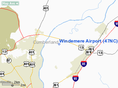
| Location: | Cumberland County, NC |
| Magnetic Variation: | 08W () |
Owner & Manager
| Ownership: | Privately owned |
| Owner: | Samuel W. Bowyer |
| Address: | P.o. Box 53186
Fayetteville, NC 28305 |
| Phone number: | 910-864-5737 |
| Manager: | Francis H. Bowyer |
| Address: | 3842 River Road
Wade, NC 28395 |
| Phone number: | 910-485-6750 |
Airport Operations and Facilities
| Airport Use: | Private |
| Wind indicator: | Yes |
| Segmented Circle: | No |
| Control Tower: | No |
| Sectional chart: | Charlotte |
| Region: | ASO - Southern |
| Boundary ARTCC: | ZDC - Washington |
| Tie-in FSS: | RDU - Raleigh |
| FSS Toll Free: | 1-800-WX-BRIEF |
Runway Information
Runway 04/22
| Dimension: | 2890 x 150 ft / 880.9 x 45.7 m |
| Surface: | TURF, |
| |
Runway 04 |
Runway 22 |
| Traffic Pattern: | Right | Left |
|
Radio Navigation Aids
| ID |
Type |
Name |
Ch |
Freq |
Var |
Dist |
| FGP | NDB | Fort Bragg | | 393.00 | 07W | 0.5 nm |
| POB | NDB | Pope | | 338.00 | 07W | 8.4 nm |
| HQT | NDB | Harnett | | 417.00 | 08W | 19.2 nm |
| EEJ | NDB | Lee County/dcmsnd | | 428.00 | 07W | 24.2 nm |
| CTZ | NDB | Clinton | | 412.00 | 08W | 24.6 nm |
| TT | NDB | Leeco | | 406.00 | 08W | 26.6 nm |
| JN | NDB | Jurly | | 263.00 | 09W | 28.1 nm |
| HFF | NDB | Mackall | | 278.00 | 06W | 33.3 nm |
| RSY | NDB | Robeson | | 359.00 | 08W | 33.6 nm |
| EUU | NDB | Jnall | | 251.00 | 07W | 36.3 nm |
| JB | NDB | Jigel | | 384.00 | 08W | 38.8 nm |
| ME | NDB | Maxtn | | 257.00 | 08W | 39.1 nm |
| TGQ | NDB | Elizabethtown | | 398.00 | 08W | 39.6 nm |
| DKA | NDB | Kenan | | 332.00 | 07W | 44.6 nm |
| RCZ | NDB | Roscoe | | 375.00 | 07W | 46.2 nm |
| ACZ | NDB | Pendy | | 379.00 | 09W | 47.7 nm |
| LE | NDB | Leevy | | 350.00 | 07W | 47.7 nm |
| TOX | NDB | Siler City | | 371.00 | 07W | 48.8 nm |
| DLC | NDB | Dillon | | 274.00 | 05W | 49.4 nm |
| POB | TACAN | Pope | 085X | | 07W | 9.8 nm |
| GSB | TACAN | Seymour Johnson | 112X | | 08W | 43.4 nm |
| LBT | VOR | Lumberton | | 110.00 | 08W | 33.7 nm |
| FAY | VOR/DME | Fayetteville | 025X | 108.80 | 04W | 9.5 nm |
| SDZ | VORTAC | Sandhills | 055X | 111.80 | 03W | 37.9 nm |
| RDU | VORTAC | Raleigh/durham | 119X | 117.20 | 04W | 44.2 nm |
Remarks
- 35 FT POWER LINE 1000 FT NORTH, 90 FT RATIO TOWER 1000 FT WEST, 40 FT BLDG 200 FT WEST OF ARPT.
- PRVDD VFR/PVT USE, ALL TFC PATS CONDUCTED EAST OF ARPT, TPA BLO 700 FT AGL, REPORTED CEILING AT SIMMONS IS NOT LESS THAN 1000 FT AND VIS AT WINDEMERE IS NOT LESS THAN 2 STATUTE MILES.
Images and information placed above are from
http://www.airport-data.com/airport/47NC/
We thank them for the data!
| General Info
|
| Country |
United States
|
| State |
NORTH CAROLINA
|
| FAA ID |
47NC
|
| Latitude |
35-08-17.000N
|
| Longitude |
078-49-22.000W
|
| Elevation |
98 feet
|
| Near City |
FAYETTEVILLE
|
We don't guarantee the information is fresh and accurate. The data may
be wrong or outdated.
For more up-to-date information please refer to other sources.
|
|