 |
|
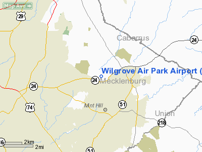
Wilgrove Air Park Airport |
Location & QuickFacts
| FAA Information Effective: | 2008-09-25 |
| Airport Identifier: | 8A6 |
| Airport Status: | Operational |
| Longitude/Latitude: | 080-40-12.2460W/35-12-49.5180N
-80.670068/35.213755 (Estimated) |
| Elevation: | 799 ft / 243.54 m (Surveyed) |
| Land: | 55 acres |
| From nearest city: | 9 nautical miles E of Charlotte, NC |
| Location: | Mecklenburg County, NC |
| Magnetic Variation: | 05W (1985) |
Owner & Manager
| Ownership: | Privately owned |
| Owner: | Wilgrove Investments, Llc |
| Address: | 10901 Robinson Church Road
Charlotte, NC 28215 |
| Phone number: | 704-545-2451 |
| Manager: | Alan Cobb |
| Address: | 10525 Parkton Rd
Charlotte, NC 28215 |
| Phone number: | 704-545-1875 |
Airport Operations and Facilities
| Airport Use: | Open to public |
| Wind indicator: | Yes |
| Segmented Circle: | No |
| Control Tower: | No |
| Lighting Schedule: | DUSK-0100
ACTIVATE NON-STD LIRL RY 17/35 - CTAF. |
| Beacon Color: | Clear-Green (lighted land airport) |
| Landing fee charge: | No |
| Sectional chart: | Charlotte |
| Region: | ASO - Southern |
| Boundary ARTCC: | ZTL - Atlanta |
| Tie-in FSS: | RDU - Raleigh |
| FSS on Airport: | No |
| FSS Toll Free: | 1-800-WX-BRIEF |
| NOTAMs Facility: | RDU (NOTAM-d service avaliable) |
Airport Communications
| CTAF: | 122.725 |
| Unicom: | 122.725 |
Airport Services
| Fuel available: | 100LL |
| Power Plant Repair: | MINOR |
Runway Information
Runway 17/35
| Dimension: | 2835 x 40 ft / 864.1 x 12.2 m |
| Surface: | ASPH, Fair Condition |
| Weight Limit: | Single wheel: 10000 lbs. |
| Edge Lights: | Non-standard lighting system
NSTD LIRL; NO THLD LGTS. |
| |
Runway 17 |
Runway 35 |
| Traffic Pattern: | Left | Left |
| Markings: | Nonstandard, Fair Condition
SMALL NUMBERS AND FADED CNTRLN. | Nonstandard, Fair Condition
RWY 35 SMALL NUMBERS AND FADED CNTRLN |
| Displaced threshold: | 100.00 ft | 200.00 ft
DSPLCD THLD MKD FOR DAY OPNS WITH THREE CONES EACH SIDE OF RY. |
| Runway End Identifier: | No | No |
| Centerline Lights: | No | No |
| Touchdown Lights: | No | No |
| Obstruction: | 54 ft trees, 400.0 ft from runway, 92 ft right of centerline, 3:1 slope to clear
RY 17 APCH SLOPE 14:1 TO DSPLCD THLD.
RWY 17 +60 FT TREES 0-200 FT FM THLD 50 FT L & R OF CNTRLN. | 60 ft trees, 374.0 ft from runway, 75 ft left of centerline, 2:1 slope to clear
RY 35 APCH SLOPE 9:1 AT DSPLCD THLD.
+5 FT FENCE 20 FT FROM ASPH ON CNTRLN; ROAD 60 FT FROM THR ON CNTRLN. |
|
Radio Navigation Aids
| ID |
Type |
Name |
Ch |
Freq |
Var |
Dist |
| TWL | NDB | Wesley | | 204.00 | 06W | 15.8 nm |
| GHJ | NDB | Stonia | | 260.00 | 06W | 24.0 nm |
| UZ | NDB | Rally | | 227.00 | 05W | 28.1 nm |
| IZN | NDB | Lincolnton | | 432.00 | 06W | 28.2 nm |
| LKR | NDB | Lancaster | | 400.00 | 07W | 30.9 nm |
| AFP | NDB | Anson County | | 283.00 | 07W | 31.0 nm |
| RU | NDB | Rovdy | | 275.00 | 06W | 32.4 nm |
| PYG | NDB | Pageland | | 270.00 | 06W | 32.6 nm |
| VU | NDB | Aller | | 346.00 | 06W | 33.3 nm |
| DCM | NDB | Chester | | 220.00 | 06W | 36.6 nm |
| SEN | NDB | Swearing/dcmsnd | | 260.00 | 06W | 38.6 nm |
| VW | NDB | Temky | | 280.00 | 05W | 38.9 nm |
| DVZ | NDB | Davie | | 354.00 | 06W | 43.3 nm |
| SLP | NDB | First River | | 417.00 | 06W | 45.7 nm |
| HK | NDB | Tawba | | 332.00 | 06W | 46.4 nm |
| CQW | NDB | Cheraw | | 409.00 | 05W | 48.7 nm |
| CQJ | NDB | City Lake | | 266.00 | 08W | 49.6 nm |
| CLT | VOR/DME | Charlotte | 097X | 115.00 | 05W | 13.9 nm |
| CTF | VOR/DME | Chesterfield | 019X | 108.20 | 03W | 39.1 nm |
| BZM | VOR/DME | Barretts Mountain | 045X | 110.80 | 06W | 48.3 nm |
| FML | VORTAC | Fort Mill | 071X | 112.40 | 02W | 19.5 nm |
| CLT | VOT | Charlotte | | 112.00 | | 13.2 nm |
| HKY | VOT | Hickory Regional | | 110.00 | | 47.4 nm |
Remarks
- TALL STEEL TOWER 2 MILES FROM THR RWY 17 APPROX 6000' RIGHT OF CNTRLN.
- ARPT CLSD TO PURE JET POWERED ACFT.
- 50' TREES WITHIN 80' OF CNTRLN BOTH SIDES.
- NUMEROUS OBSTRUCTIONS WITHIN 60 FT FM CNTRLN 15 FT-40 FT IN HEIGHT.
- DEER INVOF ARPT.
- VFR OPERATIONS ONLY.
Images and information placed above are from
http://www.airport-data.com/airport/8A6/
We thank them for the data!
| General Info
|
| Country |
United States
|
| State |
NORTH CAROLINA
|
| FAA ID |
8A6
|
| Latitude |
35-12-49.518N
|
| Longitude |
080-40-12.246W
|
| Elevation |
799 feet
|
| Near City |
CHARLOTTE
|
We don't guarantee the information is fresh and accurate. The data may
be wrong or outdated.
For more up-to-date information please refer to other sources.
|
|


