|
|
 |
(Click on the photo to enlarge) |
Location & QuickFacts
| FAA Information Effective: | 2008-09-25 |
| Airport Identifier: | 4W4 |
| Airport Status: | Operational |
| Longitude/Latitude: | 079-04-44.0450W/36-17-00.5020N
-79.078901/36.283473 (Estimated) |
| Elevation: | 653 ft / 199.03 m (Surveyed) |
| Land: | 4 acres |
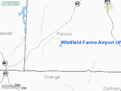
| From nearest city: | 2 nautical miles W of Hurdle Mills, NC |
| Location: | Person County, NC |
| Magnetic Variation: | 07W (1985) |
Owner & Manager
| Ownership: | Privately owned |
| Owner: | Robert O. Whitfield, Jr. |
| Address: | 1721 Robert Whitfield Rd
Hurdle Mills, NC 27451 |
| Phone number: | 336-234-0111 |
| Manager: | Robert O. Whitfield, Jr. |
| Address: | P.o. Box 549
Roxboro, NC 27573 |
| Phone number: | 336-234-0111 |
Airport Operations and Facilities
| Airport Use: | Open to public |
| Wind indicator: | Yes |
| Segmented Circle: | No |
| Control Tower: | No |
| Landing fee charge: | No |
| Sectional chart: | Cincinnati |
| Region: | ASO - Southern |
| Boundary ARTCC: | ZDC - Washington |
| Tie-in FSS: | RDU - Raleigh |
| FSS on Airport: | No |
| FSS Toll Free: | 1-800-WX-BRIEF |
| NOTAMs Facility: | RDU (NOTAM-d service avaliable) |
Airport Communications
Airport Services
Runway Information
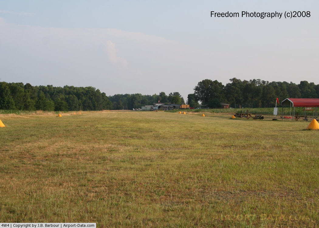
Runway 03/21
| Dimension: | 1950 x 70 ft / 594.4 x 21.3 m |
| Surface: | TURF, Good Condition |
| |
Runway 03 |
Runway 21 |
| Traffic Pattern: | Left | Left |
| Markings: | Nonstandard,
RY 03/21 NSTD MKGS; MKD BY YELLOW CONES. | , |
| Displaced threshold: | 0.00 ft | 400.00 ft |
| Obstruction: | 42 ft trees, 78.0 ft from runway, 78 ft right of centerline, 1:1 slope to clear | 34 ft trees, 376.0 ft from runway, 119 ft left of centerline, 11:1 slope to clear |
|
Radio Navigation Aids
| ID |
Type |
Name |
Ch |
Freq |
Var |
Dist |
| OQA | FAN MARKER | Rockingham County | | | | 37.4 nm |
| HUR | NDB | Person | | 220.00 | 08W | 3.1 nm |
| HXO | NDB | Huntsboro | | 271.00 | 07W | 22.3 nm |
| LE | NDB | Leevy | | 350.00 | 07W | 27.6 nm |
| HB | NDB | Himun | | 361.00 | 08W | 30.7 nm |
| SIF | NDB | Slammer | | 423.00 | 07W | 33.7 nm |
| TOX | NDB | Siler City | | 371.00 | 07W | 36.5 nm |
| UV | NDB | Bales | | 396.00 | 07W | 44.5 nm |
| TT | NDB | Leeco | | 406.00 | 08W | 47.3 nm |
| DAN | VOR | Danville | | 113.10 | 06W | 21.2 nm |
| SBV | VORTAC | South Boston | 041X | 110.40 | 05W | 23.7 nm |
| RDU | VORTAC | Raleigh/durham | 119X | 117.20 | 04W | 28.6 nm |
| LIB | VORTAC | Liberty | 077X | 113.00 | 03W | 38.4 nm |
| GSO | VORTAC | Greensboro | 109X | 116.20 | 03W | 45.8 nm |
Remarks
- BE ALERT FARM EQUIPMENT/CATTLE MAY BE ON STRIP; SALVAGE AIRCRAFT LEFT SIDE OF RWY 3
- OWNER PREFERS LANDINGS TO THE S & TKOFS TO THE N.
- SMALL RADIO CONTROL MODEL AIRPLANES OPERATE ON AIRPORT.
- NONCOMPLIANCE FAR 157.
Images and information placed above are from
http://www.airport-data.com/airport/4W4/
We thank them for the data!
| General Info
|
| Country |
United States
|
| State |
NORTH CAROLINA
|
| FAA ID |
4W4
|
| Latitude |
36-17-00.502N
|
| Longitude |
079-04-44.045W
|
| Elevation |
653 feet
|
| Near City |
HURDLE MILLS
|
We don't guarantee the information is fresh and accurate. The data may
be wrong or outdated.
For more up-to-date information please refer to other sources.
|
|