 |
|
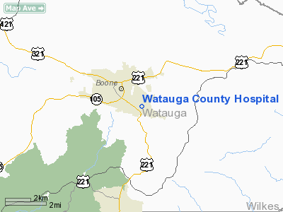
Watauga County Hospital Heliport |
Location & QuickFacts
| FAA Information Effective: | 2008-09-25 |
| Airport Identifier: | NC04 |
| Airport Status: | Operational |
| Longitude/Latitude: | 081-39-05.3820W/36-11-57.4620N
-81.651495/36.199295 (Estimated) |
| Elevation: | 2988 ft / 910.74 m (Estimated) |
| Land: | 0 acres |
| From nearest city: | 0 nautical miles N of Boone, NC |
| Location: | Watauga County, NC |
| Magnetic Variation: | 05W (1985) |
Owner & Manager
| Ownership: | Publicly owned |
| Owner: | Watauga Medical Center |
| Address: | Po Box 2600
Boone, NC 28607-2600 |
| Phone number: | 828-262-4100 |
| Manager: | Hospital Administrator |
| Address: | 336 Deerfield Road
Boone, NC 27607-5008 |
| Phone number: | 828-265-5049 |
Airport Operations and Facilities
| Airport Use: | Private
MEDICAL |
| Wind indicator: | Yes |
| Segmented Circle: | No |
| Control Tower: | No |
| Lighting Schedule: | PHONE REQ
FOR ROTG BCN AND PERIMETER LGTS CALL 704-262-4100. |
| Beacon Color: | Clear-Green-Yellow (heliport) |
| Sectional chart: | Cincinnati |
| Region: | ASO - Southern |
| Boundary ARTCC: | ZTL - Atlanta |
| Tie-in FSS: | RDU - Raleigh |
| FSS Toll Free: | 1-800-WX-BRIEF |
Airport Communications
Runway Information
Helipad H1
| Dimension: | 40 x 40 ft / 12.2 x 12.2 m |
| Surface: | CONC, |
| |
Runway H1 |
Runway |
| Traffic Pattern: | Left | Left |
|
Radio Navigation Aids
| ID |
Type |
Name |
Ch |
Freq |
Var |
Dist |
| MRN | FAN MARKER | Lenoir | | | 03W | 24.3 nm |
| BAR | NDB | Hemlock | | 320.00 | 02W | 11.4 nm |
| JJO | NDB | Mountain City | | 396.00 | 04W | 15.5 nm |
| JU | NDB | Ashee | | 410.00 | 07W | 21.3 nm |
| UKF | NDB | Wilki | | 209.00 | 06W | 27.4 nm |
| FIQ | NDB | Fiddlers | | 391.00 | 07W | 29.4 nm |
| HK | NDB | Tawba | | 332.00 | 06W | 30.0 nm |
| EZT | NDB | Elizabethton | | 275.00 | 02W | 30.8 nm |
| VJ | NDB | Whine | | 236.00 | 05W | 35.2 nm |
| VW | NDB | Temky | | 280.00 | 05W | 38.3 nm |
| BO | NDB | Booie | | 221.00 | 04W | 42.6 nm |
| ZEF | NDB | Zephyr | | 326.00 | 05W | 45.5 nm |
| MK | NDB | Suzze | | 335.00 | 06W | 47.6 nm |
| IZN | NDB | Lincolnton | | 432.00 | 06W | 48.4 nm |
| BZM | VOR/DME | Barretts Mountain | 045X | 110.80 | 06W | 28.2 nm |
| GZG | VOR/DME | Glade Spring | 039X | 110.20 | 02W | 42.9 nm |
| HMV | VORTAC | Holston Mountain | 093X | 114.60 | 04W | 27.2 nm |
| HKY | VOT | Hickory Regional | | 110.00 | | 30.3 nm |
Remarks
- PRVDD FT/PT USE; SPONSOR WILL EXECUTE/MAINTAIN OPERATIONAL LTR OF AGREEMENT W/OWNER/OPERATOR OF BOONE-BLOWING ROCK ARPT ON TRAFFIC PATTERN OPERATIONS. ALL APCH/DEP ROUTES ARE FROM 270 DEGREES TO 090 DEGREES; AREA APPROPRIATELY MARKED; AND WIND INDICATOR MAINTAINED.
Images and information placed above are from
http://www.airport-data.com/airport/NC04/
We thank them for the data!
| General Info
|
| Country |
United States
|
| State |
NORTH CAROLINA
|
| FAA ID |
NC04
|
| Latitude |
36-11-57.462N
|
| Longitude |
081-39-05.382W
|
| Elevation |
2988 feet
|
| Near City |
BOONE
|
We don't guarantee the information is fresh and accurate. The data may
be wrong or outdated.
For more up-to-date information please refer to other sources.
|
|


