 |
|
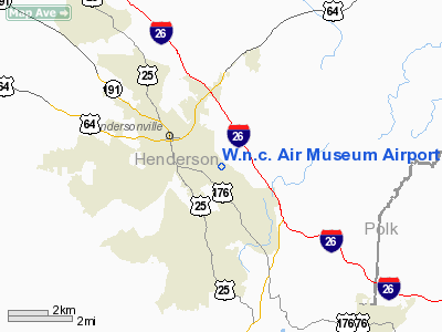
W.n.c. Air Museum Airport |
Location & QuickFacts
| FAA Information Effective: | 2008-09-25 |
| Airport Identifier: | 8NC9 |
| Airport Status: | Operational |
| Longitude/Latitude: | 082-26-01.0000W/35-18-26.0000N
-82.433611/35.307222 (Estimated) |
| Elevation: | 2083 ft / 634.90 m (Estimated) |
| Land: | 30 acres |
| From nearest city: | 1 nautical miles SE of Hendersonville, NC |
| Location: | Henderson County, NC |
| Magnetic Variation: | 05W (1995) |
Owner & Manager
| Ownership: | Privately owned |
| Owner: | Elmo Leland Johnson |
| Address: | 401 Upward Road
East Flat Rock, NC 28726-2049 |
| Phone number: | 828-693-4317 |
| Manager: | Elmo Leland Johnson |
| Address: | 401 Upward Road
East Flat Rock, NC 28726-2049 |
| Phone number: | 828-693-4317
ADDL 828-693-4317. |
Airport Operations and Facilities
| Airport Use: | Private |
| Wind indicator: | Yes |
| Segmented Circle: | No |
| Control Tower: | No |
| Sectional chart: | Atlanta |
| Region: | ASO - Southern |
| Boundary ARTCC: | ZTL - Atlanta |
| Tie-in FSS: | RDU - Raleigh |
| FSS Toll Free: | 1-800-WX-BRIEF |
Airport Communications
Runway Information
Runway 14/32
| Dimension: | 2400 x 100 ft / 731.5 x 30.5 m |
| Surface: | TURF, |
| |
Runway 14 |
Runway 32 |
| Traffic Pattern: | Left | Left |
| Obstruction: | | 75 ft trees, 300.0 ft from runway |
|
Radio Navigation Aids
| ID |
Type |
Name |
Ch |
Freq |
Var |
Dist |
| MRN | FAN MARKER | Lenoir | | | 03W | 49.3 nm |
| BRA | NDB | Broad River | | 379.00 | 04W | 2.8 nm |
| RFE | NDB | Rutherford | | 344.00 | 05W | 23.7 nm |
| LQK | NDB | Lake Keowee | | 408.00 | 04W | 32.6 nm |
| FRT | NDB | Fairmont | | 248.00 | 05W | 32.9 nm |
| GY | NDB | Dyana | | 338.00 | 03W | 37.0 nm |
| SLP | NDB | First River | | 417.00 | 06W | 41.1 nm |
| CEU | NDB | Clemson | | 257.00 | 05W | 44.1 nm |
| FIQ | NDB | Fiddlers | | 391.00 | 07W | 44.5 nm |
| SUG | VORTAC | Sugarloaf Mountain | 059X | 112.20 | 02W | 10.1 nm |
| SPA | VORTAC | Spartanburg | 104X | 115.70 | 02W | 29.8 nm |
| SOT | VORTAC | Snowbird | 025X | 108.80 | 04W | 41.9 nm |
Remarks
- HENDERSONVILLE ARPT LCTD 500 FT EAST OF ARPT.
- PRVDD VFR, PVT USE, LETTER OF AGREEMENT WITH HENDERSONVILLE ARPT, CLEAR 20:1 APCH ON ALL RYS.
Images and information placed above are from
http://www.airport-data.com/airport/8NC9/
We thank them for the data!
| General Info
|
| Country |
United States
|
| State |
NORTH CAROLINA
|
| FAA ID |
8NC9
|
| Latitude |
35-18-26.000N
|
| Longitude |
082-26-01.000W
|
| Elevation |
2083 feet
|
| Near City |
HENDERSONVILLE
|
We don't guarantee the information is fresh and accurate. The data may
be wrong or outdated.
For more up-to-date information please refer to other sources.
|
|


