 |
|
 |
(Click on the photo to enlarge) |
Location & QuickFacts
| FAA Information Effective: | 2008-09-25 |
| Airport Identifier: | NC69 |
| Airport Status: | Operational |
| Longitude/Latitude: | 078-28-27.0190W/34-52-15.6130N
-78.474172/34.871004 (Estimated) |
| Elevation: | 125 ft / 38.10 m (Estimated) |
| Land: | 36 acres |
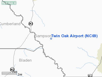
| From nearest city: | 10 nautical miles SW of Clinton, NC |
| Location: | Sampson County, NC |
| Magnetic Variation: | 07W (1985) |
Owner & Manager
| Ownership: | Privately owned |
| Owner: | Ray Dailey |
| Address: | 13129 Boykin Bridge Road
Roseboro, NC 28382-5300 |
| Phone number: | 910-564-6010 |
| Manager: | Ray Dailey |
| Address: | 13129 Boykin Bridge Road
Rosebord, NC 28382-5300 |
| Phone number: | 910-564-6010 |
Airport Operations and Facilities
| Airport Use: | Private |
| Wind indicator: | Yes |
| Segmented Circle: | No |
| Control Tower: | No |
| Sectional chart: | Charlotte |
| Region: | ASO - Southern |
| Boundary ARTCC: | ZDC - Washington |
| Tie-in FSS: | RDU - Raleigh |
| FSS Toll Free: | 1-800-WX-BRIEF |
Runway Information
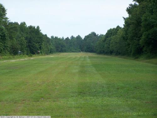
Runway 15/33
| Dimension: | 2300 x 60 ft / 701.0 x 18.3 m |
| Surface: | TURF-GRVL, |
| |
Runway 15 |
Runway 33 |
| Traffic Pattern: | Left | Left |
| Obstruction: | 30 ft pline, 50.0 ft from runway | |
|
Radio Navigation Aids
| ID |
Type |
Name |
Ch |
Freq |
Var |
Dist |
| CTZ | NDB | Clinton | | 412.00 | 08W | 8.3 nm |
| TGQ | NDB | Elizabethtown | | 398.00 | 08W | 20.7 nm |
| FGP | NDB | Fort Bragg | | 393.00 | 07W | 23.2 nm |
| ACZ | NDB | Pendy | | 379.00 | 09W | 25.0 nm |
| DKA | NDB | Kenan | | 332.00 | 07W | 29.9 nm |
| POB | NDB | Pope | | 338.00 | 07W | 31.9 nm |
| RSY | NDB | Robeson | | 359.00 | 08W | 32.8 nm |
| HQT | NDB | Harnett | | 417.00 | 08W | 35.2 nm |
| JN | NDB | Jurly | | 263.00 | 09W | 36.4 nm |
| CPC | NDB | Camp | | 227.00 | 07W | 37.9 nm |
| JB | NDB | Jigel | | 384.00 | 08W | 38.2 nm |
| EUU | NDB | Jnall | | 251.00 | 07W | 44.6 nm |
| EEJ | NDB | Lee County/dcmsnd | | 428.00 | 07W | 47.6 nm |
| JYN | NDB | Wayne | | 208.00 | 08W | 48.4 nm |
| ME | NDB | Maxtn | | 257.00 | 08W | 48.6 nm |
| TT | NDB | Leeco | | 406.00 | 08W | 49.9 nm |
| POB | TACAN | Pope | 085X | | 07W | 32.0 nm |
| GSB | TACAN | Seymour Johnson | 112X | | 08W | 37.3 nm |
| LBT | VOR | Lumberton | | 110.00 | 08W | 32.7 nm |
| FAY | VOR/DME | Fayetteville | 025X | 108.80 | 04W | 20.9 nm |
| ILM | VORTAC | Wilmington | 117X | 117.00 | 07W | 43.1 nm |
Remarks
Images and information placed above are from
http://www.airport-data.com/airport/NC69/
We thank them for the data!
| General Info
|
| Country |
United States
|
| State |
NORTH CAROLINA
|
| FAA ID |
NC69
|
| Latitude |
34-52-15.613N
|
| Longitude |
078-28-27.019W
|
| Elevation |
125 feet
|
| Near City |
CLINTON
|
We don't guarantee the information is fresh and accurate. The data may
be wrong or outdated.
For more up-to-date information please refer to other sources.
|
|


