 |
|
| Twin Lakes Airport |
| IATA: none – ICAO: none – FAA LID: 8A7 |
| Summary |
| Airport type |
Public |
| Owner |
Dr. Phillip Martin |
| Serves |
Mocksville, North Carolina |
| Elevation AMSL |
818 ft / 249 m |
| Coordinates |
35°54′54″N 080°27′25″W / 35.915°N 80.45694°W / 35.915; -80.45694 |
| Runways |
| Direction |
Length |
Surface |
| ft |
m |
| 9/27 |
2,943 |
897 |
Asphalt |
| Statistics (2007) |
| Aircraft operations |
30,000 |
| Based aircraft |
92 |
| Source: Federal Aviation Administration |
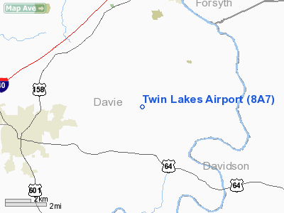
Twin Lakes Airport (FAA LID: 8A7) is a privately-owned, public-use airport located five miles (8 km) northeast of the central business district of Mocksville, in Davie County, North Carolina, United States.
Facilities and aircraft
Twin Lakes Airport covers an area of 100 acres (40 ha) and has one runway designated 9/27 with a 2,943 x 50 ft (897 x 15 m) asphalt surface. For the 12-month period ending August 10, 2007, the airport had 30,000 aircraft operations, an average of 82 per day: 97% general aviation and 3% military. At that time there were 92 aircraft based at this airport: 88% single-engine, 10% multi-engine, 1% helicopter and 1% glider.
The above content comes from Wikipedia and is published under free licenses – click here to read more.
Location & QuickFacts
| FAA Information Effective: | 2008-09-25 |
| Airport Identifier: | 8A7 |
| Airport Status: | Operational |
| Longitude/Latitude: | 080-27-24.5030W/35-54-53.6940N
-80.456806/35.914915 (Estimated) |
| Elevation: | 818 ft / 249.33 m (Surveyed) |
| Land: | 100 acres |
| From nearest city: | 5 nautical miles NE of Mocksville, NC |
| Location: | Davie County, NC |
| Magnetic Variation: | 06W (1985) |
Owner & Manager
| Ownership: | Privately owned |
| Owner: | Dr. Phillip Martin |
| Address: | 1105 Fork Bixby Rd
Advance, NC 27006 |
| Phone number: | 336-998-8101 |
| Manager: | Marcie Gentle |
| Address: | 1105 Fork Bixby Rd
Advance, NC 27006 |
| Phone number: | 336-998-8101 |
Airport Operations and Facilities
| Airport Use: | Open to public |
| Wind indicator: | Yes |
| Segmented Circle: | No |
| Control Tower: | No |
| Lighting Schedule: | DUSK-DAWN |
| Beacon Color: | Clear (unlighted land airport) |
| Landing fee charge: | No |
| Sectional chart: | Charlotte |
| Region: | ASO - Southern |
| Traffic Pattern Alt: | 800 ft |
| Boundary ARTCC: | ZTL - Atlanta |
| Tie-in FSS: | RDU - Raleigh |
| FSS on Airport: | No |
| FSS Toll Free: | 1-800-WX-BRIEF |
| NOTAMs Facility: | RDU (NOTAM-d service avaliable) |
Airport Communications
| CTAF: | 122.700 |
| Unicom: | 122.700 |
Airport Services
| Fuel available: | 100LL |
| Airframe Repair: | MAJOR |
| Power Plant Repair: | MAJOR |
| Bottled Oxygen: | NONE |
| Bulk Oxygen: | NONE |
Runway Information
Runway 09/27
| Dimension: | 2943 x 50 ft / 897.0 x 15.2 m |
| Surface: | ASPH, Fair Condition |
| Weight Limit: | Single wheel: 12500 lbs. |
| Edge Lights: | Low |
| |
Runway 09 |
Runway 27 |
| Longitude: | 080-27-42.4160W | 080-27-06.6600W |
| Latitude: | 35-54-53.1980N | 35-54-54.1760N |
| Elevation: | 773.00 ft | 818.00 ft |
| Alignment: | 88 | 127 |
| Traffic Pattern: | Left | Left |
| Markings: | Basic, Poor Condition
RY 09 PAINT FADED. | Basic, Poor Condition
RY 27 PAINT FADED. |
| VASI: | 2-light PAPI on right side
PAPI OPERATES CONTINUOUSLY. | |
| Obstruction: | 66 ft trees, 363.0 ft from runway, 256 ft right of centerline, 2:1 slope to clear | 87 ft trees, 395.0 ft from runway, 216 ft right of centerline, 2:1 slope to clear |
|
Radio Navigation Aids
| ID |
Type |
Name |
Ch |
Freq |
Var |
Dist |
| OQA | FAN MARKER | Rockingham County | | | | 43.3 nm |
| RU | NDB | Rovdy | | 275.00 | 06W | 11.0 nm |
| SEN | NDB | Swearing/dcmsnd | | 260.00 | 06W | 11.2 nm |
| ZEF | NDB | Zephyr | | 326.00 | 05W | 27.2 nm |
| AZW | NDB | Mount Airy | | 223.00 | 07W | 28.3 nm |
| VW | NDB | Temky | | 280.00 | 05W | 30.8 nm |
| CQJ | NDB | City Lake | | 266.00 | 08W | 31.2 nm |
| VU | NDB | Aller | | 346.00 | 06W | 31.5 nm |
| UKF | NDB | Wilki | | 209.00 | 06W | 33.4 nm |
| IZN | NDB | Lincolnton | | 432.00 | 06W | 38.2 nm |
| HK | NDB | Tawba | | 332.00 | 06W | 42.1 nm |
| HB | NDB | Himun | | 361.00 | 08W | 42.6 nm |
| SIF | NDB | Slammer | | 423.00 | 07W | 43.8 nm |
| UV | NDB | Bales | | 396.00 | 07W | 48.3 nm |
| TOX | NDB | Siler City | | 371.00 | 07W | 49.3 nm |
| BZM | VOR/DME | Barretts Mountain | 045X | 110.80 | 06W | 38.3 nm |
| CLT | VOR/DME | Charlotte | 097X | 115.00 | 05W | 49.8 nm |
| GSO | VORTAC | Greensboro | 109X | 116.20 | 03W | 24.7 nm |
| LIB | VORTAC | Liberty | 077X | 113.00 | 03W | 41.6 nm |
| HKY | VOT | Hickory Regional | | 110.00 | | 46.7 nm |
| CLT | VOT | Charlotte | | 112.00 | | 48.2 nm |
Remarks
- RY 09 -18 FT DROP-OFF 150 FT FROM THR LEFT & RIGHT OF CNTRLN.
- RY 09 UPHILL GRADE.
- DEER/MIGRATORY BIRDS OCNLLY ON ARPT.
Images and information placed above are from
http://www.airport-data.com/airport/8A7/
We thank them for the data!
| General Info
|
| Country |
United States
|
| State |
NORTH CAROLINA
|
| FAA ID |
8A7
|
| Latitude |
35-54-53.694N
|
| Longitude |
080-27-24.503W
|
| Elevation |
818 feet
|
| Near City |
MOCKSVILLE
|
We don't guarantee the information is fresh and accurate. The data may
be wrong or outdated.
For more up-to-date information please refer to other sources.
|
|


