 |
|
 |
(Click on the photo to enlarge) |
Location & QuickFacts
| FAA Information Effective: | 2008-09-25 |
| Airport Identifier: | 5W5 |
| Airport Status: | Operational |
| Longitude/Latitude: | 078-42-00.9400W/35-37-13.2500N
-78.700261/35.620347 (Estimated) |
| Elevation: | 244 ft / 74.37 m (Surveyed) |
| Land: | 50 acres |
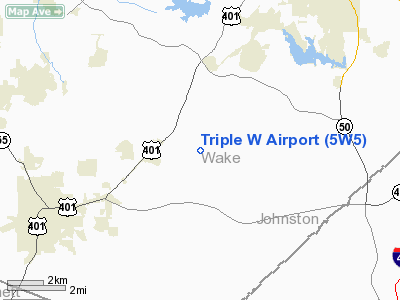
| From nearest city: | 11 nautical miles SW of Raleigh, NC |
| Location: | Wake County, NC |
| Magnetic Variation: | 07W (1985) |
Owner & Manager
| Ownership: | Privately owned |
| Owner: | Triple W Enterprises Inc |
| Address: | 3605 Turnbridge Drive
Raleigh, NC 27609 |
| Phone number: | 919-782-1855 |
| Manager: | Paul Williams |
| Address: | 3512 Wind Haven Drive
Fuquay Varina, NC 27526 |
| Phone number: | 919-552-6877 |
Airport Operations and Facilities
| Airport Use: | Open to public |
| Wind indicator: | Yes |
| Segmented Circle: | No |
| Control Tower: | No |
| Lighting Schedule: | DUSK-DAWN
ACTIVATE LIRL - CTAF. |
| Beacon Color: | Clear-Green (lighted land airport) |
| Landing fee charge: | No |
| Sectional chart: | Charlotte |
| Region: | ASO - Southern |
| Boundary ARTCC: | ZDC - Washington |
| Tie-in FSS: | RDU - Raleigh |
| FSS on Airport: | No |
| FSS Toll Free: | 1-800-WX-BRIEF |
| NOTAMs Facility: | RDU (NOTAM-d service avaliable) |
Airport Communications
| CTAF: | 122.700 |
| Unicom: | 122.700 |
Airport Services
| Airframe Repair: | MAJOR |
| Power Plant Repair: | MAJOR |
| Bottled Oxygen: | NONE |
| Bulk Oxygen: | NONE |
Runway Information
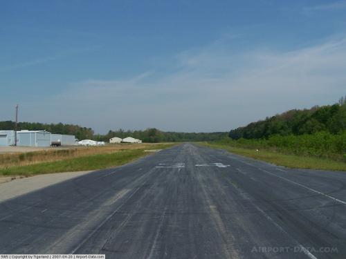
Runway 16/34
| Dimension: | 3004 x 40 ft / 915.6 x 12.2 m |
| Surface: | ASPH, Fair Condition |
| Edge Lights: | Non-standard lighting system
NSTD LIRL - LGTS 15 FT FROM EDGE OF RY. RY 16 THLD LGTS 150 FT FM THLD; RY 34 THLD LGTS 460 FT FM THLD. |
| |
Runway 16 |
Runway 34 |
| Traffic Pattern: | Left | Left |
| Markings: | Nonstandard, Poor Condition
RY 16 CNTRLN MKG ONLY; MKGS FADED. NRS 50 FT FROM THLD. RY 34 CNTRLN MKG ONLY; MKG FADED. NRS 400 FT FM THLD. | Nonstandard, Poor Condition |
| Obstruction: | 82 ft trees, 668.0 ft from runway, 121 ft right of centerline, 5:1 slope to clear | 47 ft trees, 496.0 ft from runway, 106 ft right of centerline, 5:1 slope to clear |
|
Radio Navigation Aids
| ID |
Type |
Name |
Ch |
Freq |
Var |
Dist |
| HQT | NDB | Harnett | | 417.00 | 08W | 11.3 nm |
| JN | NDB | Jurly | | 263.00 | 09W | 16.0 nm |
| EUU | NDB | Jnall | | 251.00 | 07W | 16.9 nm |
| LE | NDB | Leevy | | 350.00 | 07W | 18.5 nm |
| TT | NDB | Leeco | | 406.00 | 08W | 22.7 nm |
| POB | NDB | Pope | | 338.00 | 07W | 26.7 nm |
| FGP | NDB | Fort Bragg | | 393.00 | 07W | 29.5 nm |
| EEJ | NDB | Lee County/dcmsnd | | 428.00 | 07W | 29.6 nm |
| RW | NDB | Jambe | | 235.00 | 09W | 37.0 nm |
| TOX | NDB | Siler City | | 371.00 | 07W | 38.2 nm |
| JYN | NDB | Wayne | | 208.00 | 08W | 39.5 nm |
| HUR | NDB | Person | | 220.00 | 08W | 40.9 nm |
| HXO | NDB | Huntsboro | | 271.00 | 07W | 41.1 nm |
| CTZ | NDB | Clinton | | 412.00 | 08W | 42.1 nm |
| HB | NDB | Himun | | 361.00 | 08W | 48.2 nm |
| POB | TACAN | Pope | 085X | | 07W | 31.8 nm |
| GSB | TACAN | Seymour Johnson | 112X | | 08W | 39.6 nm |
| FAY | VOR/DME | Fayetteville | 025X | 108.80 | 04W | 39.1 nm |
| RDU | VORTAC | Raleigh/durham | 119X | 117.20 | 04W | 15.7 nm |
| LIB | VORTAC | Liberty | 077X | 113.00 | 03W | 46.0 nm |
| SDZ | VORTAC | Sandhills | 055X | 111.80 | 03W | 49.8 nm |
Remarks
- ALL ACFT OVER 6500 LBS PROHIBITED.
- RY 16/34 PAEW PARL TWY.
- BE ALERT FOR RISING TERRAIN ALL QUADRANTS.
- 4 FT DROPOFF TAXIWAY EDGE BOTH SIDES - SOUTH END.
- TOWER (500' AGL/ 826' MSL) APPROX 1.75 NM NW OF ARPT.
- NUMEROUS UNLGTD OBSTR INVOF ARPT.
- RY 16/34 HAS 4 FT DROPOFF 20 FT FROM PAVEMENT EDGE ALL SIDES.
- TWY NOT LIGHTED.
- VFR USE ONLY.
Images and information placed above are from
http://www.airport-data.com/airport/5W5/
We thank them for the data!
| General Info
|
| Country |
United States
|
| State |
NORTH CAROLINA
|
| FAA ID |
5W5
|
| Latitude |
35-37-13.250N
|
| Longitude |
078-42-00.940W
|
| Elevation |
244 feet
|
| Near City |
RALEIGH
|
We don't guarantee the information is fresh and accurate. The data may
be wrong or outdated.
For more up-to-date information please refer to other sources.
|
|


