|
|
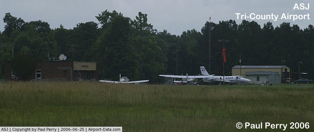
| Tri-County Airport |
| IATA: none – ICAO: KASJ – FAA LID: ASJ |
| Summary |
| Airport type |
Public |
| Operator |
Tri-County Airport Authority |
| Location |
Ahoskie, North Carolina |
| Elevation AMSL |
68 ft / 20.7 m |
| Coordinates |
36°17′51″N 077°10′15″W / 36.2975°N 77.17083°W / 36.2975; -77.17083Coordinates: 36°17′51″N 077°10′15″W / 36.2975°N 77.17083°W / 36.2975; -77.17083 |
| Runways |
| Direction |
Length |
Surface |
| ft |
m |
| 1/19 |
4,502 |
1,372 |
Asphalt |
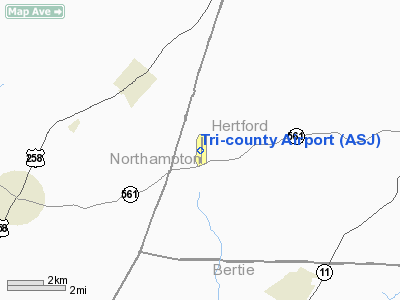
Tri-County Airport (ICAO: KASJ, FAA LID: ASJ) is a public airport located nine miles (14 km) west of the central business district (CBD) of Ahoskie, a town in Hertford County, North Carolina, USA. This general aviation airport covers 210 acres (85 ha) and has one runway.
Although most U.S. airports use the same three-letter location identifier for the FAA and IATA, Tri-County Airport is assigned ASJ by the FAA and has no assignment from the IATA (which assigned ASJ to Amami O Shima, Japan). The airport's ICAO identifier is KASJ.
The above content comes from Wikipedia and is published under free licenses – click here to read more.
 |
(Click on the photo to enlarge) |
Location & QuickFacts
| FAA Information Effective: | 2008-09-25 |
| Airport Identifier: | ASJ |
| Airport Status: | Operational |
| Longitude/Latitude: | 077-10-15.0800W/36-17-51.0930N
-77.170856/36.297526 (Estimated) |
| Elevation: | 68 ft / 20.73 m (Surveyed) |
| Land: | 210 acres |
| From nearest city: | 9 nautical miles W of Ahoskie, NC |
| Location: | Hertford County, NC |
| Magnetic Variation: | 10W (2000) |
Owner & Manager
| Ownership: | Publicly owned |
| Owner: | Tri-county Airport Auth. |
| Address: | 140 Tri-county Airport Rd
Aulander, NC 27805 |
| Phone number: | 252-345-9962 |
| Manager: | Henry Joyner |
| Address: | 140 Tri-county Airport Rd
Aulander, NC 27805 |
| Phone number: | 252-345-0111
FOR AMGR AFTER HOURS CALL 252-532-6569 |
Airport Operations and Facilities
| Airport Use: | Open to public |
| Wind indicator: | Yes |
| Segmented Circle: | Yes |
| Control Tower: | No |
| Lighting Schedule: | DUSK-DAWN
ACTVT MIRL RY 01/19, REIL RY 01 & 19 - CTAF. |
| Beacon Color: | Clear-Green (lighted land airport) |
| Landing fee charge: | No |
| Sectional chart: | Washington |
| Region: | ASO - Southern |
| Boundary ARTCC: | ZDC - Washington |
| Tie-in FSS: | RDU - Raleigh |
| FSS on Airport: | No |
| FSS Toll Free: | 1-800-WX-BRIEF |
| NOTAMs Facility: | ASJ (NOTAM-d service avaliable) |
| Federal Agreements: | NY1 |
Airport Communications
| CTAF: | 122.800 |
| Unicom: | 122.800 |
Airport Services
| Fuel available: | 100LLA1+ |
| Airframe Repair: | NONE |
| Power Plant Repair: | NONE |
| Bottled Oxygen: | NONE |
| Bulk Oxygen: | NONE |
Runway Information
Runway 01/19
| Dimension: | 4502 x 75 ft / 1372.2 x 22.9 m |
| Surface: | ASPH, Good Condition |
| Weight Limit: | Single wheel: 35000 lbs.
Dual wheel: 45000 lbs. |
| Edge Lights: | Medium |
| |
Runway 01 |
Runway 19 |
| Longitude: | 077-10-14.3380W | 077-10-15.8190W |
| Latitude: | 36-17-28.8580N | 36-18-13.3360N |
| Elevation: | 68.00 ft | 68.00 ft |
| Alignment: | 127 | 127 |
| Traffic Pattern: | Left | Left |
| Markings: | Non-precision instrument, Fair Condition | Non-precision instrument, Fair Condition |
| VASI: | 2-light PAPI on left side | 2-light PAPI on left side |
| Runway End Identifier: | Yes | Yes |
| Obstruction: | 75 ft trees, 2068.0 ft from runway, 353 ft left of centerline, 25:1 slope to clear
3 FT GROUND 0-200 FT FROM THLD 185 L. | 50 ft trees, 753.0 ft from runway, 184 ft right of centerline, 11:1 slope to clear |
|
Radio Navigation Aids
| ID |
Type |
Name |
Ch |
Freq |
Var |
Dist |
| PGV | FAN MARKER | Belvoir | | | 06W | 40.8 nm |
| ASJ | NDB | Ahoskie | | 415.00 | 10W | 0.3 nm |
| ELQ | NDB | Emporia | | 261.00 | 10W | 22.9 nm |
| MCZ | NDB | Williamston | | 336.00 | 09W | 26.4 nm |
| RZZ | NDB | Rapids | | 407.00 | 08W | 27.4 nm |
| ETC | NDB | Tarboro | | 257.00 | 08W | 28.4 nm |
| RK | NDB | Waley | | 249.00 | 10W | 31.1 nm |
| EDE | NDB | Edenton | | 265.00 | 10W | 33.6 nm |
| PMZ | NDB | Plymouth | | 221.00 | 10W | 35.4 nm |
| AQE | NDB | Alwood | | 230.00 | 09W | 36.8 nm |
| AKQ | NDB | Wakefield | | 274.00 | 09W | 42.0 nm |
| EY | NDB | Chesi | | 233.00 | 09W | 42.3 nm |
| LLW | NDB | Woodville | | 254.00 | 10W | 42.3 nm |
| PVG | NDB | Portsmouth | | 241.00 | 10W | 45.5 nm |
| AEA | NDB | Jones | | 373.00 | 09W | 46.7 nm |
| RNW | NDB | Chocowinity | | 388.00 | 07W | 47.5 nm |
| MBV | NDB | Mecklenburg/dcmsnd | | 356.00 | 08W | 48.9 nm |
| ECG | VOR/DME | Elizabeth City | 072X | 112.50 | 07W | 48.3 nm |
| CVI | VORTAC | Cofield | 093X | 114.60 | 09W | 15.2 nm |
| FKN | VORTAC | Franklin | 043X | 110.60 | 09W | 26.2 nm |
| TYI | VORTAC | Tar River | 125X | 117.80 | 05W | 32.3 nm |
| LVL | VORTAC | Lawrenceville | 076X | 112.90 | 08W | 47.2 nm |
Remarks
- TWY UNLGTD.
- ARPT PHONE 919-345-0111.
- RY 01/19 -4 FT DITCH 120 FT L & R OF CNTRLN.
Images and information placed above are from
http://www.airport-data.com/airport/ASJ/
We thank them for the data!
| General Info
|
| Country |
United States
|
| State |
NORTH CAROLINA
|
| FAA ID |
ASJ
|
| Latitude |
36-17-51.093N
|
| Longitude |
077-10-15.080W
|
| Elevation |
68 feet
|
| Near City |
AHOSKIE
|
We don't guarantee the information is fresh and accurate. The data may
be wrong or outdated.
For more up-to-date information please refer to other sources.
|
|