 |
|
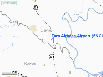
Location & QuickFacts
| FAA Information Effective: | 2008-09-25 |
| Airport Identifier: | 5NC1 |
| Airport Status: | Operational |
| Longitude/Latitude: | 080-30-44.2120W/35-47-35.4990N
-80.512281/35.793194 (Estimated) |
| Elevation: | 756 ft / 230.43 m (Estimated) |
| Land: | 0 acres |
| From nearest city: | 4 nautical miles N of Mocksville, NC |
| Location: | Davie County, NC |
| Magnetic Variation: | 06W (1985) |
Owner & Manager
| Ownership: | Privately owned |
| Owner: | Colonial Airlines |
| Address: |
|
| Manager: | Novaro Nichols |
| Address: | 227 Riverdale Road
Mocksville, NC 27028 |
| Phone number: | 336-284-2151 |
Airport Operations and Facilities
| Airport Use: | Private |
| Wind indicator: | Yes |
| Segmented Circle: | No |
| Control Tower: | No |
| Lighting Schedule: | PHONE REQ
FOR ROTG BCN CALL 704-284-2161. |
| Beacon Color: | Clear-Green (lighted land airport)
FOR RTG BCN CALL 336-284-2161. |
| Sectional chart: | Charlotte |
| Region: | ASO - Southern |
| Boundary ARTCC: | ZTL - Atlanta |
| Tie-in FSS: | RDU - Raleigh |
| FSS Toll Free: | 1-800-WX-BRIEF |
Airport Communications
Airport Services
Runway Information
Runway 18/36
| Dimension: | 2100 x 75 ft / 640.1 x 22.9 m |
| Surface: | TURF, |
| |
Runway 18 |
Runway 36 |
| Traffic Pattern: | Left | Left |
| Obstruction: | 50 ft trees, 1000.0 ft from runway | 10 ft trees, 500.0 ft from runway |
|
Radio Navigation Aids
| ID |
Type |
Name |
Ch |
Freq |
Var |
Dist |
| RU | NDB | Rovdy | | 275.00 | 06W | 3.8 nm |
| DVZ | NDB | Davie | | 354.00 | 06W | 7.7 nm |
| SEN | NDB | Swearing/dcmsnd | | 260.00 | 06W | 10.5 nm |
| VW | NDB | Temky | | 280.00 | 05W | 27.0 nm |
| VU | NDB | Aller | | 346.00 | 06W | 27.9 nm |
| CQJ | NDB | City Lake | | 266.00 | 08W | 31.9 nm |
| IZN | NDB | Lincolnton | | 432.00 | 06W | 32.0 nm |
| ZEF | NDB | Zephyr | | 326.00 | 05W | 32.9 nm |
| UKF | NDB | Wilki | | 209.00 | 06W | 34.4 nm |
| AZW | NDB | Mount Airy | | 223.00 | 07W | 35.4 nm |
| HK | NDB | Tawba | | 332.00 | 06W | 38.7 nm |
| HB | NDB | Himun | | 361.00 | 08W | 46.5 nm |
| GHJ | NDB | Stonia | | 260.00 | 06W | 48.0 nm |
| BZM | VOR/DME | Barretts Mountain | 045X | 110.80 | 06W | 35.8 nm |
| CLT | VOR/DME | Charlotte | 097X | 115.00 | 05W | 42.1 nm |
| GSO | VORTAC | Greensboro | 109X | 116.20 | 03W | 30.2 nm |
| LIB | VORTAC | Liberty | 077X | 113.00 | 03W | 43.9 nm |
| CLT | VOT | Charlotte | | 112.00 | | 40.5 nm |
| HKY | VOT | Hickory Regional | | 110.00 | | 43.0 nm |
Remarks
Images and information placed above are from
http://www.airport-data.com/airport/5NC1/
We thank them for the data!
| General Info
|
| Country |
United States
|
| State |
NORTH CAROLINA
|
| FAA ID |
5NC1
|
| Latitude |
35-47-35.499N
|
| Longitude |
080-30-44.212W
|
| Elevation |
756 feet
|
| Near City |
MOCKSVILLE
|
We don't guarantee the information is fresh and accurate. The data may
be wrong or outdated.
For more up-to-date information please refer to other sources.
|
|


