 |
|
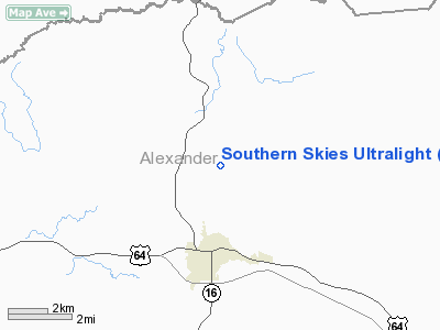
Southern Skies Ultralight Airport |
Location & QuickFacts
| FAA Information Effective: | 2008-09-25 |
| Airport Identifier: | NR04 |
| Airport Status: | Operational |
| Longitude/Latitude: | 081-10-23.0000W/35-57-37.0000N
-81.173056/35.960278 (Estimated) |
| Elevation: | 1180 ft / 359.66 m (Estimated) |
| Land: | 65 acres |
| From nearest city: | 3 nautical miles N of Taylorsville, NC |
| Location: | Alexander County, NC |
| Magnetic Variation: | () |
Owner & Manager
| Ownership: | Privately owned |
| Owner: | Southern Skies |
| Address: | 1122jolly Cemetery Rd
Taylorsville, NC 28681 |
| Phone number: | 828-632-6000 |
| Manager: | Chris Bowles |
| Address: | 331 Moore Mtn Rd
Moravian Falls, NC 28654 |
| Phone number: | 828-632-6000 |
Airport Operations and Facilities
| Airport Use: | Private |
| Wind indicator: | Yes |
| Control Tower: | No |
| Sectional chart: | Atlanta |
| Region: | ASO - Southern |
| Boundary ARTCC: | ZTL - Atlanta |
| Tie-in FSS: | RDU - Raleigh |
| FSS Toll Free: | 1-800-WX-BRIEF |
Runway Information
Runway 09U/27U
| Dimension: | 800 x 100 ft / 243.8 x 30.5 m |
| Surface: | TURF, |
| |
Runway 09U |
Runway 27U |
| Traffic Pattern: | Left | Left |
| Obstruction: | | 90 ft trees, 3000.0 ft from runway |
|
Radio Navigation Aids
| ID |
Type |
Name |
Ch |
Freq |
Var |
Dist |
| MRN | FAN MARKER | Lenoir | | | 03W | 24.1 nm |
| UKF | NDB | Wilki | | 209.00 | 06W | 9.9 nm |
| HK | NDB | Tawba | | 332.00 | 06W | 12.3 nm |
| VW | NDB | Temky | | 280.00 | 05W | 12.3 nm |
| IZN | NDB | Lincolnton | | 432.00 | 06W | 25.8 nm |
| FIQ | NDB | Fiddlers | | 391.00 | 07W | 28.6 nm |
| JU | NDB | Ashee | | 410.00 | 07W | 29.4 nm |
| ZEF | NDB | Zephyr | | 326.00 | 05W | 30.4 nm |
| DVZ | NDB | Davie | | 354.00 | 06W | 35.0 nm |
| RU | NDB | Rovdy | | 275.00 | 06W | 36.0 nm |
| BAR | NDB | Hemlock | | 320.00 | 02W | 36.3 nm |
| AZW | NDB | Mount Airy | | 223.00 | 07W | 39.8 nm |
| JJO | NDB | Mountain City | | 396.00 | 04W | 41.8 nm |
| SEN | NDB | Swearing/dcmsnd | | 260.00 | 06W | 44.0 nm |
| GHJ | NDB | Stonia | | 260.00 | 06W | 46.2 nm |
| SLP | NDB | First River | | 417.00 | 06W | 47.3 nm |
| BZM | VOR/DME | Barretts Mountain | 045X | 110.80 | 06W | 6.4 nm |
| CLT | VOR/DME | Charlotte | 097X | 115.00 | 05W | 47.5 nm |
| HKY | VOT | Hickory Regional | | 110.00 | | 16.9 nm |
| CLT | VOT | Charlotte | | 112.00 | | 46.3 nm |
Remarks
- PRVDD VFR OPNS & PVT USE.
Images and information placed above are from
http://www.airport-data.com/airport/NR04/
We thank them for the data!
|
|


