 |
|
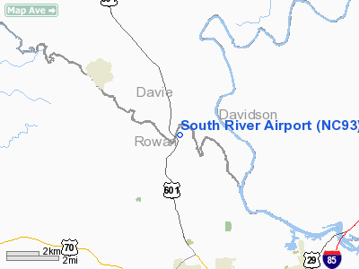
Location & QuickFacts
| FAA Information Effective: | 2008-09-25 |
| Airport Identifier: | NC93 |
| Airport Status: | Operational |
| Longitude/Latitude: | 080-30-05.0000W/35-46-40.0000N
-80.501389/35.777778 (Estimated) |
| Elevation: | 650 ft / 198.12 m (Estimated) |
| Land: | 28 acres |
| From nearest city: | 7 nautical miles N of Salisbury, NC |
| Location: | Rowan County, NC |
| Magnetic Variation: | 06W (1995) |
Owner & Manager
| Ownership: | Privately owned |
| Owner: | Alfred Wilson |
| Address: | 8660 U.s. 601
Salisbury, NC 28147 |
| Phone number: | 704-633-8013 |
| Manager: | Alfred Wilson |
| Address: | 8660 U.s. 601
Salisbury, NC 28147 |
| Phone number: | 704-633-8013 |
Airport Operations and Facilities
| Airport Use: | Private |
| Segmented Circle: | No |
| Control Tower: | No |
| Sectional chart: | Charlotte |
| Region: | ASO - Southern |
| Boundary ARTCC: | ZTL - Atlanta |
| Tie-in FSS: | RDU - Raleigh |
| FSS Toll Free: | 1-800-WX-BRIEF |
Runway Information
Runway 07/25
| Dimension: | 1850 x 50 ft / 563.9 x 15.2 m |
| Surface: | TURF, |
| |
Runway 07 |
Runway 25 |
| Traffic Pattern: | Left | Left |
| Obstruction: | 50 ft trees, 250.0 ft from runway | |
|
Radio Navigation Aids
| ID |
Type |
Name |
Ch |
Freq |
Var |
Dist |
| RU | NDB | Rovdy | | 275.00 | 06W | 2.7 nm |
| DVZ | NDB | Davie | | 354.00 | 06W | 8.4 nm |
| SEN | NDB | Swearing/dcmsnd | | 260.00 | 06W | 9.9 nm |
| VU | NDB | Aller | | 346.00 | 06W | 26.9 nm |
| VW | NDB | Temky | | 280.00 | 05W | 27.5 nm |
| CQJ | NDB | City Lake | | 266.00 | 08W | 31.2 nm |
| IZN | NDB | Lincolnton | | 432.00 | 06W | 32.0 nm |
| ZEF | NDB | Zephyr | | 326.00 | 05W | 33.9 nm |
| UKF | NDB | Wilki | | 209.00 | 06W | 35.3 nm |
| AZW | NDB | Mount Airy | | 223.00 | 07W | 36.3 nm |
| HK | NDB | Tawba | | 332.00 | 06W | 39.2 nm |
| HB | NDB | Himun | | 361.00 | 08W | 46.2 nm |
| GHJ | NDB | Stonia | | 260.00 | 06W | 47.7 nm |
| AFP | NDB | Anson County | | 283.00 | 07W | 49.7 nm |
| BZM | VOR/DME | Barretts Mountain | 045X | 110.80 | 06W | 36.4 nm |
| CLT | VOR/DME | Charlotte | 097X | 115.00 | 05W | 41.6 nm |
| GSO | VORTAC | Greensboro | 109X | 116.20 | 03W | 30.2 nm |
| LIB | VORTAC | Liberty | 077X | 113.00 | 03W | 43.4 nm |
| CLT | VOT | Charlotte | | 112.00 | | 40.0 nm |
| HKY | VOT | Hickory Regional | | 110.00 | | 43.5 nm |
Remarks
- LNDG, TKOF & OTHER OPNS LIMITED TO RY 25.
- PRVDD VFR, PVT USE. OPNS W OF ARPT CONDUCTED VIA TELEPHONE OR RADIO WITH TARA ARPT OR LIMIT OPNS TO E END OF ARPT.
Images and information placed above are from
http://www.airport-data.com/airport/NC93/
We thank them for the data!
| General Info
|
| Country |
United States
|
| State |
NORTH CAROLINA
|
| FAA ID |
NC93
|
| Latitude |
35-46-40.000N
|
| Longitude |
080-30-05.000W
|
| Elevation |
650 feet
|
| Near City |
SALISBURY
|
We don't guarantee the information is fresh and accurate. The data may
be wrong or outdated.
For more up-to-date information please refer to other sources.
|
|


