 |
|
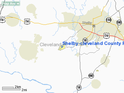
Shelby-cleveland County Rgnl Airport |
Location & QuickFacts
| FAA Information Effective: | 2008-09-25 |
| Airport Identifier: | EHO |
| Airport Status: | Operational |
| Longitude/Latitude: | 081-36-02.7000W/35-15-20.7000N
-81.600750/35.255750 (Estimated) |
| Elevation: | 847 ft / 258.17 m (Surveyed) |
| Land: | 225 acres |
| From nearest city: | 3 nautical miles SW of Shelby, NC |
| Location: | Cleveland County, NC |
| Magnetic Variation: | 06W (2000) |
Owner & Manager
| Ownership: | Publicly owned |
| Owner: | City Of Shelby |
| Address: | Po Box 207
Shelby, NC 28151 |
| Phone number: | 704-484-6803 |
| Manager: | Devon Raisch |
| Address: | 830 College Ave
Shelby, NC 28150 |
| Phone number: | 704-487-1161 |
Airport Operations and Facilities
| Airport Use: | Open to public |
| Wind indicator: | Yes |
| Segmented Circle: | Yes |
| Control Tower: | No |
| Lighting Schedule: | DUSK-DAWN
AFTER 2300 ACTVT MIRL RY 05/23 - CTAF. |
| Beacon Color: | Clear-Green (lighted land airport) |
| Landing fee charge: | No |
| Sectional chart: | Atlanta |
| Region: | ASO - Southern |
| Boundary ARTCC: | ZTL - Atlanta |
| Tie-in FSS: | RDU - Raleigh |
| FSS on Airport: | No |
| FSS Toll Free: | 1-800-WX-BRIEF |
| NOTAMs Facility: | RDU (NOTAM-d service avaliable) |
| Federal Agreements: | N1 |
Airport Communications
| CTAF: | 122.800 |
| Unicom: | 122.800 |
Airport Services
| Airframe Repair: | MAJOR |
| Power Plant Repair: | MAJOR |
| Bottled Oxygen: | NONE |
| Bulk Oxygen: | NONE |
Runway Information
Runway 05/23
| Dimension: | 5002 x 100 ft / 1524.6 x 30.5 m |
| Surface: | ASPH, Good Condition |
| Weight Limit: | Single wheel: 21000 lbs. |
| Edge Lights: | Medium |
| |
Runway 05 |
Runway 23 |
| Longitude: | 081-36-23.6567W | 081-35-41.8402W |
| Latitude: | 35-15-02.8791N | 35-15-38.5146N |
| Elevation: | 834.00 ft | 837.00 ft |
| Alignment: | 44 | 127 |
| Traffic Pattern: | Left | Left |
| Markings: | Non-precision instrument, Good Condition | Non-precision instrument, Good Condition |
| Crossing Height: | 41.00 ft | 28.00 ft |
| VASI: | 2-light PAPI on left side | 2-light PAPI on left side
PAPI OTS INDEFLY. |
| Visual Glide Angle: | 3.00° | 3.00° |
| Runway End Identifier: | No | No |
| Centerline Lights: | No | No |
| Touchdown Lights: | No | No |
| Obstruction: | 92 ft trees, 1300.0 ft from runway, 10 ft right of centerline, 11:1 slope to clear | 81 ft , 1230.0 ft from runway, 134 ft left of centerline, 12:1 slope to clear |
|
Radio Navigation Aids
| ID |
Type |
Name |
Ch |
Freq |
Var |
Dist |
| MRN | FAN MARKER | Lenoir | | | 03W | 32.5 nm |
| SLP | NDB | First River | | 417.00 | 06W | 0.2 nm |
| RFE | NDB | Rutherford | | 344.00 | 05W | 18.2 nm |
| GHJ | NDB | Stonia | | 260.00 | 06W | 22.1 nm |
| FIQ | NDB | Fiddlers | | 391.00 | 07W | 27.5 nm |
| FRT | NDB | Fairmont | | 248.00 | 05W | 28.4 nm |
| IZN | NDB | Lincolnton | | 432.00 | 06W | 30.4 nm |
| UZ | NDB | Rally | | 227.00 | 05W | 33.7 nm |
| DCM | NDB | Chester | | 220.00 | 06W | 34.4 nm |
| UOT | NDB | Union County | | 326.00 | 04W | 34.4 nm |
| HK | NDB | Tawba | | 332.00 | 06W | 35.0 nm |
| VW | NDB | Temky | | 280.00 | 05W | 40.7 nm |
| BRA | NDB | Broad River | | 379.00 | 04W | 42.7 nm |
| TWL | NDB | Wesley | | 204.00 | 06W | 47.7 nm |
| LUX | NDB | Laurens | | 307.00 | 04W | 48.1 nm |
| LKR | NDB | Lancaster | | 400.00 | 07W | 48.6 nm |
| CLT | VOR/DME | Charlotte | 097X | 115.00 | 05W | 32.1 nm |
| BZM | VOR/DME | Barretts Mountain | 045X | 110.80 | 06W | 40.8 nm |
| SPA | VORTAC | Spartanburg | 104X | 115.70 | 02W | 20.9 nm |
| SUG | VORTAC | Sugarloaf Mountain | 059X | 112.20 | 02W | 34.0 nm |
| FML | VORTAC | Fort Mill | 071X | 112.40 | 02W | 35.6 nm |
| HKY | VOT | Hickory Regional | | 110.00 | | 30.9 nm |
| CLT | VOT | Charlotte | | 112.00 | | 32.6 nm |
Remarks
- NO LIGHTS ON TAXIWAY.
- FBO PHONE 704-487-1161, CELL 704 284-3321, FAX 704-284-1160.
- RY 23 HAS 35 FT DROP-OFF 600 FT FM THLD 0B.
- RY 05 HAS 45 FT DROP-OFF 100 FT FM THLD 0B.
Images and information placed above are from
http://www.airport-data.com/airport/EHO/
We thank them for the data!
| General Info
|
| Country |
United States
|
| State |
NORTH CAROLINA
|
| FAA ID |
EHO
|
| Latitude |
35-15-20.000N
|
| Longitude |
081-36-03.590W
|
| Elevation |
847 feet
|
| Near City |
SHELBY
|
We don't guarantee the information is fresh and accurate. The data may
be wrong or outdated.
For more up-to-date information please refer to other sources.
|
|


