 |
|
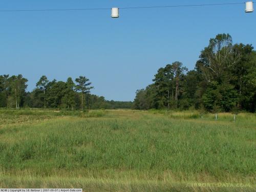 |
(Click on the photo to enlarge) |
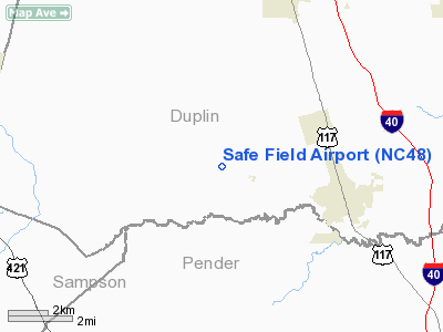
Location & QuickFacts
| FAA Information Effective: | 2008-09-25 |
| Airport Identifier: | NC48 |
| Airport Status: | Operational |
| Longitude/Latitude: | 078-03-35.9540W/34-45-00.6080N
-78.059987/34.750169 (Estimated) |
| Elevation: | 50 ft / 15.24 m (Estimated) |
| Land: | 5 acres |
| From nearest city: | 4 nautical miles W of Wallace, NC |
| Location: | Duplin County, NC |
| Magnetic Variation: | 07W (1985) |
Owner & Manager
| Ownership: | Privately owned |
| Owner: | Eugene C. Colwell |
| Address: | Route 1 Box 61
Wallace, NC 28466 |
| Phone number: | 910-285-7915 |
| Manager: | Eugene C. Colwell |
| Address: | Route 1 Box 61
Wallace, NC 28466 |
| Phone number: | 910-285-7915 |
Airport Operations and Facilities
| Airport Use: | Private |
| Wind indicator: | Yes |
| Segmented Circle: | No |
| Control Tower: | No |
| Sectional chart: | Charlotte |
| Region: | ASO - Southern |
| Boundary ARTCC: | ZDC - Washington |
| Tie-in FSS: | RDU - Raleigh |
| FSS Toll Free: | 1-800-WX-BRIEF |
Runway Information
Runway 10/28
| Dimension: | 3000 x 70 ft / 914.4 x 21.3 m |
| Surface: | TURF, |
| |
Runway 10 |
Runway 28 |
| Traffic Pattern: | Left | Left |
| Obstruction: | | 30 ft pline, 200.0 ft from runway |
|
Radio Navigation Aids
| ID |
Type |
Name |
Ch |
Freq |
Var |
Dist |
| ACZ | NDB | Pendy | | 379.00 | 09W | 3.5 nm |
| CTZ | NDB | Clinton | | 412.00 | 08W | 20.2 nm |
| DKA | NDB | Kenan | | 332.00 | 07W | 20.6 nm |
| TGQ | NDB | Elizabethtown | | 398.00 | 08W | 26.2 nm |
| NCA | NDB | New River | | 356.00 | 08W | 31.2 nm |
| CLB | NDB | Carolina Beach | | 216.00 | 04W | 39.0 nm |
| CPC | NDB | Camp | | 227.00 | 07W | 43.3 nm |
| FGP | NDB | Fort Bragg | | 393.00 | 07W | 43.8 nm |
| JN | NDB | Jurly | | 263.00 | 09W | 47.1 nm |
| JYN | NDB | Wayne | | 208.00 | 08W | 47.3 nm |
| SUT | NDB | Yaupon | | 233.00 | 08W | 49.4 nm |
| DIW | NDB/DME | Dixon | 107X | 198.00 | 08W | 31.9 nm |
| NCA | TACAN | New River | 101X | | 08W | 30.7 nm |
| GSB | TACAN | Seymour Johnson | 112X | | 08W | 35.4 nm |
| LBT | VOR | Lumberton | | 110.00 | 08W | 49.9 nm |
| FAY | VOR/DME | Fayetteville | 025X | 108.80 | 04W | 42.6 nm |
| ILM | VORTAC | Wilmington | 117X | 117.00 | 07W | 25.7 nm |
| ISO | VORTAC | Kinston | 033X | 109.60 | 05W | 44.7 nm |
Remarks
- VFR/PVT USE ONLY; TRAFFIC PATTERNS REMAIN WEST OF RY.
Images and information placed above are from
http://www.airport-data.com/airport/NC48/
We thank them for the data!
| General Info
|
| Country |
United States
|
| State |
NORTH CAROLINA
|
| FAA ID |
NC48
|
| Latitude |
34-45-00.608N
|
| Longitude |
078-03-35.954W
|
| Elevation |
50 feet
|
| Near City |
WALLACE
|
We don't guarantee the information is fresh and accurate. The data may
be wrong or outdated.
For more up-to-date information please refer to other sources.
|
|


