 |
|
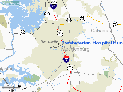
Presbyterian Hospital Huntersville Heliport |
Location & QuickFacts
| FAA Information Effective: | 2008-09-25 |
| Airport Identifier: | 31NC |
| Airport Status: | Operational |
| Longitude/Latitude: | 080-51-33.0000W/35-24-24.0000N
-80.859167/35.406667 (Estimated) |
| Elevation: | 753 ft / 229.51 m (Estimated) |
| Land: | 0 acres |
| From nearest city: | 1 nautical miles WS of Huntersville, NC |
| Location: | Mecklenburg County, NC |
| Magnetic Variation: | () |
Owner & Manager
| Ownership: | Privately owned |
| Owner: | Presbyterian Healthcare |
| Address: | 10030 Gilead Road
Huntersville, NC 28078 |
| Phone number: | 704-384-4000 |
| Manager: | Terry Fair |
| Address: | 10030 Gilead Road
Huntersville, NC 28078 |
| Phone number: | 704-384-4000 |
Airport Operations and Facilities
| Airport Use: | Private
MEDICAL USE. |
| Wind indicator: | Yes |
| Control Tower: | No |
| Lighting Schedule: | DUSK-DAWN |
| Sectional chart: | Charlotte |
| Region: | ASO - Southern |
| Boundary ARTCC: | ZTL - Atlanta |
| Tie-in FSS: | RDU - Raleigh |
| FSS Toll Free: | 1-800-WX-BRIEF |
Runway Information
Helipad H1
| Dimension: | 50 x 50 ft / 15.2 x 15.2 m |
| Surface: | CONC, |
| |
Runway H1 |
Runway |
| Traffic Pattern: | Left | Left |
|
Radio Navigation Aids
| ID |
Type |
Name |
Ch |
Freq |
Var |
Dist |
| MRN | FAN MARKER | Lenoir | | | 03W | 44.1 nm |
| IZN | NDB | Lincolnton | | 432.00 | 06W | 13.6 nm |
| GHJ | NDB | Stonia | | 260.00 | 06W | 19.5 nm |
| VW | NDB | Temky | | 280.00 | 05W | 24.3 nm |
| RU | NDB | Rovdy | | 275.00 | 06W | 26.7 nm |
| TWL | NDB | Wesley | | 204.00 | 06W | 28.3 nm |
| HK | NDB | Tawba | | 332.00 | 06W | 31.6 nm |
| UZ | NDB | Rally | | 227.00 | 05W | 32.9 nm |
| SEN | NDB | Swearing/dcmsnd | | 260.00 | 06W | 35.4 nm |
| DVZ | NDB | Davie | | 354.00 | 06W | 36.3 nm |
| SLP | NDB | First River | | 417.00 | 06W | 37.4 nm |
| VU | NDB | Aller | | 346.00 | 06W | 38.5 nm |
| DCM | NDB | Chester | | 220.00 | 06W | 40.9 nm |
| LKR | NDB | Lancaster | | 400.00 | 07W | 41.0 nm |
| FIQ | NDB | Fiddlers | | 391.00 | 07W | 43.7 nm |
| UKF | NDB | Wilki | | 209.00 | 06W | 44.0 nm |
| AFP | NDB | Anson County | | 283.00 | 07W | 44.5 nm |
| PYG | NDB | Pageland | | 270.00 | 06W | 47.3 nm |
| CLT | VOR/DME | Charlotte | 097X | 115.00 | 05W | 13.8 nm |
| BZM | VOR/DME | Barretts Mountain | 045X | 110.80 | 06W | 33.4 nm |
| FML | VORTAC | Fort Mill | 071X | 112.40 | 02W | 25.5 nm |
| CLT | VOT | Charlotte | | 112.00 | | 12.2 nm |
| HKY | VOT | Hickory Regional | | 110.00 | | 32.9 nm |
Remarks
- PRVDD VFR OPNS, PVT USE, AREA IS MARKED, AND WIND INDICATOR IS MAINTAINED.
Images and information placed above are from
http://www.airport-data.com/airport/31NC/
We thank them for the data!
| General Info
|
| Country |
United States
|
| State |
NORTH CAROLINA
|
| FAA ID |
31NC
|
| Latitude |
35-54-14.600N
|
| Longitude |
078-16-09.000W
|
| Elevation |
300 feet
|
| Near City |
ZEBULON
|
We don't guarantee the information is fresh and accurate. The data may
be wrong or outdated.
For more up-to-date information please refer to other sources.
|
|


