 |
|
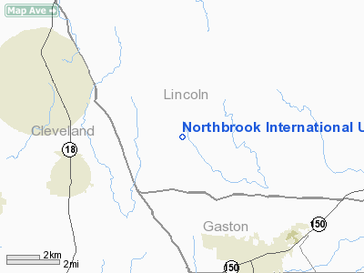
Northbrook Intl Ultraport Ultralight Airport |
Location & QuickFacts
| FAA Information Effective: | 2008-09-25 |
| Airport Identifier: | 1NC9 |
| Airport Status: | Operational |
| Longitude/Latitude: | 081-25-35.0000W/35-26-59.0000N
-81.426389/35.449722 (Estimated) |
| Elevation: | 1030 ft / 313.94 m (Estimated) |
| Land: | 0 acres |
| From nearest city: | 5 nautical miles N of Cherryville, NC |
| Location: | Lincoln County, NC |
| Magnetic Variation: | 05W (1990) |
Owner & Manager
| Ownership: | Privately owned |
| Owner: | James K Peeler |
| Address: | 2491 Hwy 274
Cherryville, NC 28021 |
| Phone number: | 704-435-4931 |
| Manager: | James K Peeler |
| Address: | Rt 1 Box 414d
Cherryville, NC 28021 |
| Phone number: | 704-435-4931 |
Airport Operations and Facilities
| Airport Use: | Private |
| Segmented Circle: | No |
| Control Tower: | No |
| Sectional chart: | Atlanta |
| Region: | ASO - Southern |
| Boundary ARTCC: | ZTL - Atlanta |
| Tie-in FSS: | RDU - Raleigh |
| FSS Toll Free: | 1-800-WX-BRIEF |
Runway Information
Runway 08/26
| Dimension: | 1200 x 75 ft / 365.8 x 22.9 m |
| Surface: | TURF, |
| |
Runway 08 |
Runway 26 |
| Traffic Pattern: | Left | Left |
| Obstruction: | 30 ft pline, 300.0 ft from runway | 20 ft trees, 250.0 ft from runway |
|
Radio Navigation Aids
| ID |
Type |
Name |
Ch |
Freq |
Var |
Dist |
| MRN | FAN MARKER | Lenoir | | | 03W | 23.0 nm |
| SLP | NDB | First River | | 417.00 | 06W | 14.6 nm |
| IZN | NDB | Lincolnton | | 432.00 | 06W | 17.5 nm |
| FIQ | NDB | Fiddlers | | 391.00 | 07W | 19.7 nm |
| GHJ | NDB | Stonia | | 260.00 | 06W | 20.4 nm |
| HK | NDB | Tawba | | 332.00 | 06W | 21.1 nm |
| VW | NDB | Temky | | 280.00 | 05W | 26.3 nm |
| RFE | NDB | Rutherford | | 344.00 | 05W | 26.5 nm |
| UZ | NDB | Rally | | 227.00 | 05W | 37.7 nm |
| DCM | NDB | Chester | | 220.00 | 06W | 41.4 nm |
| FRT | NDB | Fairmont | | 248.00 | 05W | 42.8 nm |
| UKF | NDB | Wilki | | 209.00 | 06W | 43.0 nm |
| TWL | NDB | Wesley | | 204.00 | 06W | 46.3 nm |
| UOT | NDB | Union County | | 326.00 | 04W | 47.2 nm |
| BAR | NDB | Hemlock | | 320.00 | 02W | 47.7 nm |
| RU | NDB | Rovdy | | 275.00 | 06W | 48.9 nm |
| BZM | VOR/DME | Barretts Mountain | 045X | 110.80 | 06W | 26.8 nm |
| CLT | VOR/DME | Charlotte | 097X | 115.00 | 05W | 28.0 nm |
| SPA | VORTAC | Spartanburg | 104X | 115.70 | 02W | 35.1 nm |
| FML | VORTAC | Fort Mill | 071X | 112.40 | 02W | 36.1 nm |
| SUG | VORTAC | Sugarloaf Mountain | 059X | 112.20 | 02W | 41.3 nm |
| HKY | VOT | Hickory Regional | | 110.00 | | 17.6 nm |
| CLT | VOT | Charlotte | | 112.00 | | 27.8 nm |
Remarks
Images and information placed above are from
http://www.airport-data.com/airport/1NC9/
We thank them for the data!
| General Info
|
| Country |
United States
|
| State |
NORTH CAROLINA
|
| FAA ID |
1NC9
|
| Latitude |
35-26-59.000N
|
| Longitude |
081-25-35.000W
|
| Elevation |
1030 feet
|
| Near City |
CHERRYVILLE
|
We don't guarantee the information is fresh and accurate. The data may
be wrong or outdated.
For more up-to-date information please refer to other sources.
|
|


