|
|
New River Mcas /h/ /mccutcheon Fld/ Airport |
Coordinates: 34°42′26″N 077°26′43″W / 34.70722°N 77.44528°W / 34.70722; -77.44528
MCAS New River
McCutcheon Field |
 |
| MCAS New River Insignia |
| IATA: none – ICAO: KNCA – FAA LID: NCA |
| Summary |
| Airport type |
Military |
| Operator |
United States Marine Corps |
| Location |
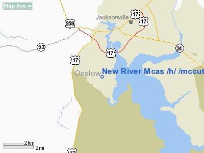
Jacksonville, North Carolina |
| Built |
1943 |
| In use |
1943 - present |
| Commander |
Col. Darrell L. Thacker, Jr. |
| Occupants |
Marine Aircraft Group 29
Marine Aircraft Group 26 |
| Elevation AMSL |
26 ft / 8 m |
| Website |
www.newriver.usmc.mil |
| Runways |
| Direction |
Length |
Surface |
| ft |
m |
| 1/19 |
4,790 |
1,460 |
Asphalt |
| 5/23 |
5,114 |
1,559 |
Asphalt |
| Sources: Official website and FAA |
Marine Corps Air Station New River (ICAO: KNCA, FAA LID: NCA) is a United States Marine Corps helicopter base in Jacksonville, North Carolina, in the eastern part of the state. In 1972, the airfield was named McCutcheon Field for Brigadier General Keith B. McCutcheon, one of the fathers of Marine Corps helicopter aviation. Near Marine Corps Base Camp Lejeune, it shares some facilities with Camp Geiger. Resident units
- Headquarters and Headquarters Squadron
- Marine Aircraft Group 26
- Marine Aircraft Group 29
- Center for Naval Aviation Technical Training
- Marine Wing Support Squadron 272
- Marine Air Control Squadron 2, Det. B
- 362d Training Squadron (USAF)
History
The base was originally 29 parcels of land, a simple stretch of tobacco farm that was purchased for $64,502 in 1941. Officials at Camp Lejeune investigated the area in search of an existing airfield for hosting aircraft in support of amphibious operations. Capt. Barnett Robinson, a member of Marine Glider Group 71, concluded in his search that the farmland would suit the Marine Corps’ needs.
The location was placed under the command of Marine Corps Base Camp Lejeune and received its first squadron, VMSB-331 from Marine Corps Air Station Cherry Point on March 9, 1943. On June 1, VMSB-331 was divided in half to create VMSB-332 however both squadrons were soon after relocated to Bogue Field. From mid-1943 through August 1944 the PBJ squadrons VMB-433, VMB-443 and VMB-612 were stationed there. In April 26, 1944, the area of land around New River and Peterfield Point, named after the original owner of the farmland that was part of the government purchase, was commissioned Marine Corps Auxiliary Airfield Camp Lejeune. This delineated the airfield from Camp Lejeune, and marks its official birth as a Marine Corps installation. Over the next few years, paratrooper Marines, glider troops and air delivery personnel where trained in King Air hangar, the Stations’ first hangar, which was transported from Marine Corps Recruit Depot Parris Island, South Carolina.
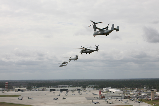 | |
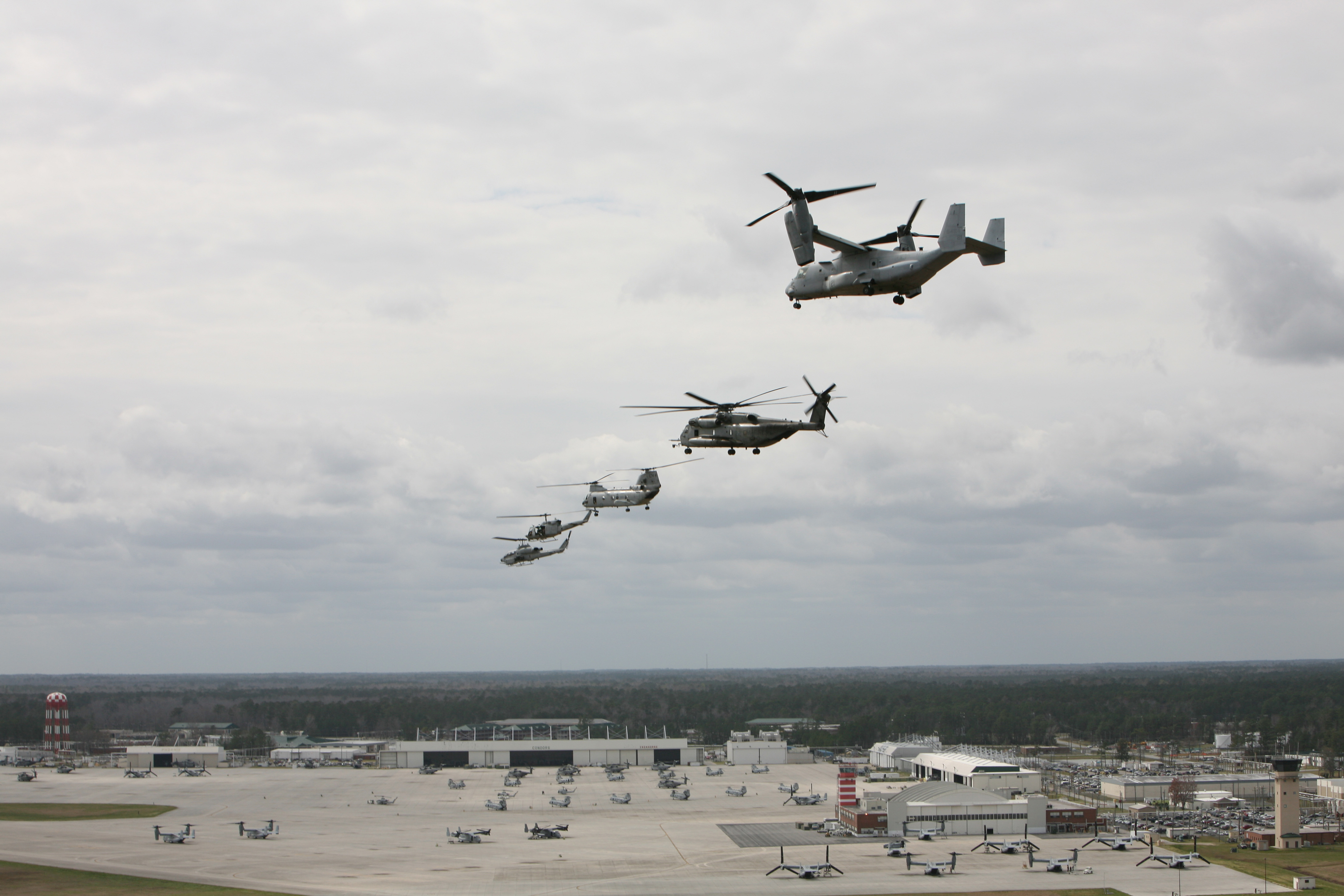
From right, a V-22 Osprey, a CH-53E Super Stallion, a CH-46 Sea Knight, a UH-1N Huey, and an AH-1 Cobra fly in formation over Marine Corps Air Station New River, North Carolina, March 18, 2008. |
As World War II came to an end, MCAAF Camp Lejeune was closed and reverted back to caretaker status as an outlying airfield of MCAS Cherry Point. This didn’t last long, however, as in 1951 the installation was reactivated and became Marine Corps Air Facility Peterfield Point, Camp Lejeune. Only one year later the name was changed again, this time to Marine Corps Air Facility New River. July 1954 marked the arrival of the first operational Marine Aircraft Group, MAG-26, which was transferred from MCAS Cherry Point.
The area faced another major name change in 1968, where it was recommissioned as Marine Corps Air Station (Helicopter) New River, marking its growth from a small training area to a major operational airfield.
MV-22 Osprey
The Air Station was the first Marine Corps base with the new MV-22 Osprey. It has the ability to fly like a plane, and take off and land like a helicopter. The MV-22 has replaced all of the CH-46E Sea Knights on the east coast. Currently there are six operational Osprey squadrons, VMM-261, VMM-263, VMM-162, VMM-365, VMM-264, and VMM-266.
The above content comes from Wikipedia and is published under free licenses – click here to read more.
Location & QuickFacts
| FAA Information Effective: | 2008-09-25 |
| Airport Identifier: | NCA |
| Airport Status: | Operational |
| Longitude/Latitude: | 077-26-42.5900W/34-42-26.4100N
-77.445164/34.707336 (Estimated) |
| Elevation: | 26 ft / 7.92 m (Estimated) |
| Land: | 0 acres |
| From nearest city: | 3 nautical miles S of Jacksonville, NC |
| Location: | Onslow County, NC |
| Magnetic Variation: | 08W (1990) |
Owner & Manager
| Ownership: | Navy owned |
| Owner: | Us Navy |
| Address: | Oceanographic Ofc-code 3142
Washington, DC 20373 |
| Manager: | Commanding Officer |
| Address: | Mcas New River
Jacksonville, NC 28540 |
| Phone number: | 910-449-6311
BASE OPS PHONE 910-449-6316. |
Airport Operations and Facilities
| Airport Use: | Private |
| Segmented Circle: | No |
| Control Tower: | Yes |
| Lighting Schedule: | DUSK-DAWN |
| Beacon Color: | Split-Clear-Green (lighted military airport) |
| Sectional chart: | Charlotte |
| Region: | ASO - Southern |
| Boundary ARTCC: | ZDC - Washington |
| Tie-in FSS: | NCA - New River Mcas
FSS-RALEIGH RDU-NOTAM RDU |
| FSS on Airport: | No |
| FSS Toll Free: | 1-800-WX-BRIEF |
| NOTAMs Facility: | RDU (NOTAM-d service avaliable) |
Airport Services
| Bottled Oxygen: | NONE |
| Bulk Oxygen: | NONE |
Runway Information
Runway 01/19
| Dimension: | 4790 x 150 ft / 1460.0 x 45.7 m |
| Surface: | ASPH, |
| Pavement Class: | 18 /F/B/W/T |
| Weight Limit: | Single wheel: 118000 lbs.
Dual wheel: 153000 lbs.
Dual tandem wheel: 230000 lbs. |
| Edge Lights: | High |
| |
Runway 01 |
Runway 19 |
| ILS Type: | ILS/DME
| |
| Traffic Pattern: | Left | Left |
| Approach lights: | SALSF | |
|
Runway 05/23
| Dimension: | 5114 x 150 ft / 1558.7 x 45.7 m |
| Surface: | ASPH, |
| Pavement Class: | 17 /F/B/W/T |
| Edge Lights: | High |
| |
Runway 05 |
Runway 23 |
| Longitude: | 077-26-54.4300W | 077-26-11.1500W |
| Latitude: | 34-42-16.5900N | 34-42-52.3900N |
| Elevation: | 24.00 ft | 16.00 ft |
| Alignment: | 45 | 127 |
| Traffic Pattern: | Left | Left |
| Approach lights: | SALSF | ALSF1 |
|
Radio Navigation Aids
| ID |
Type |
Name |
Ch |
Freq |
Var |
Dist |
| NCA | NDB | New River | | 356.00 | 08W | 1.2 nm |
| ACZ | NDB | Pendy | | 379.00 | 09W | 27.6 nm |
| DKA | NDB | Kenan | | 332.00 | 07W | 32.0 nm |
| MRH | NDB | Morehead | | 269.00 | 08W | 38.7 nm |
| CLB | NDB | Carolina Beach | | 216.00 | 04W | 44.3 nm |
| CTZ | NDB | Clinton | | 412.00 | 08W | 48.1 nm |
| DIW | NDB/DME | Dixon | 107X | 198.00 | 08W | 8.4 nm |
| NCA | TACAN | New River | 101X | | 08W | 0.2 nm |
| NJM | TACAN | Bogue Mcalf | 067X | | 08W | 20.7 nm |
| NKT | TACAN | Cherry Point | 075X | | 09W | 30.5 nm |
| GSB | TACAN | Seymour Johnson | 112X | | 08W | 45.8 nm |
| EWN | VOR/DME | New Bern | 083X | 113.60 | 08W | 29.5 nm |
| ILM | VORTAC | Wilmington | 117X | 117.00 | 07W | 30.1 nm |
| ISO | VORTAC | Kinston | 033X | 109.60 | 05W | 40.3 nm |
Remarks
- LGT: RWY 19 AND 23 THLD LGT VARY FR 1' TO 15' FR EDGE OF THE PAVEMENT.
- LIGHTING AVBL ONLY DURG OPERATING HRS.
- FUEL: J5; FUEL SVC MON-FRI 1300Z++ TIL 1 HR PRIOR TO FLD CLOSURE; CLSD SAT, SUN AND HOL.
- TRAN ALERT: PPR 1200-0300Z++ MON-THU; 1200-24000Z++ FRI; 1400-2000Z++ SAT; 17000-2300Z++SUN; CLSD HOL. FOR RON CTC HOST UNIT. NO CLSD FLD AUTH FOR TRAN ACFT.
- RSTD: PPR ONLY. DSN 752-6311/6316, C910-449-6311/6316. TWY A AT MID-FLD CLSD TO C-130 AND LARGER ACFT.
- CAUTION: BIRD HAZ OCT-APR. EXTV DEER HAZ NGT.
- TFC PAT: TACTICAL JETS PROH FULL STOP ONLY (NON-V/STOL).
- NS ABMT: VFR TOUCH AND GO NA FOR ALL ACFT 0400Z++. CLSD FLD OPS NA FOR TRAN ACFT.
- OPR 1200-0600Z++ MON-THU; 1200-2400Z++ FRI; 1400-2000Z++ SAT; 1700-2300Z++SUN, CLSD HOL. AFLD SUBJ TO CHANGE BY NOTAM.
Images and information placed above are from
http://www.airport-data.com/airport/NCA/
We thank them for the data!
| General Info
|
| Country |
United States
|
| State |
NORTH CAROLINA
|
| FAA ID |
NCA
|
| Latitude |
34-42-38.590N
|
| Longitude |
077-26-20.870W
|
| Elevation |
25 feet
|
| Near City |
JACKSONVILLE
|
We don't guarantee the information is fresh and accurate. The data may
be wrong or outdated.
For more up-to-date information please refer to other sources.
|
|