 |
|
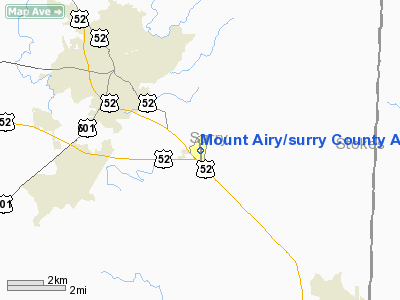
Mount Airy/surry County Airport |
| Mount Airy/Surry County Airport |
| IATA: none – ICAO: KMWK – FAA LID: MWK |
| Summary |
| Airport type |
Public |
| Operator |
City of Mount Airy and Surry County |
| Location |
Mount Airy, North Carolina |
| Elevation AMSL |
1,247 ft / 380.1 m |
| Coordinates |
36°27′35″N 080°33′11″W / 36.45972°N 80.55306°W / 36.45972; -80.55306Coordinates: 36°27′35″N 080°33′11″W / 36.45972°N 80.55306°W / 36.45972; -80.55306 |
| Runways |
| Direction |
Length |
Surface |
| ft |
m |
| 18/36 |
4,300 |
1,311 |
Asphalt |
Mount Airy/Surry County Airport (ICAO: KMWK, FAA LID: MWK) is a public airport located near the city of Mount Airy in Surry County, North Carolina, USA.
The above content comes from Wikipedia and is published under free licenses – click here to read more.
Location & QuickFacts
| FAA Information Effective: | 2008-09-25 |
| Airport Identifier: | MWK |
| Airport Status: | Operational |
| Longitude/Latitude: | 080-33-10.7000W/36-27-35.0000N
-80.552972/36.459722 (Estimated) |
| Elevation: | 1249 ft / 380.70 m (Surveyed) |
| Land: | 147 acres |
| From nearest city: | 3 nautical miles SE of Mount Airy, NC |
| Location: | Surry County, NC |
| Magnetic Variation: | 07W (1995) |
Owner & Manager
| Ownership: | Publicly owned |
| Owner: | City And County |
| Address: | 146 Howard Woltz Jr. Way
Mount Airy, NC 27030-9020 |
| Phone number: | 336-789-5153 |
| Manager: | Kelvin Boyette |
| Address: | 146 Howard Woltz Jr. Way
Mount Airy, NC 27030-9020 |
| Phone number: | 336-789-5153 |
Airport Operations and Facilities
| Airport Use: | Open to public |
| Wind indicator: | Yes |
| Segmented Circle: | Yes |
| Control Tower: | No |
| Lighting Schedule: | DUSK-DAWN
MIRL RY 18/36 OPER DUSK-2230; AFT 2230 ACTVT - CTAF. ACTVT PAPI RYS 18 & 36 AND REIL RY 36 - CTAF. |
| Beacon Color: | Clear-Green (lighted land airport) |
| Landing fee charge: | No |
| Sectional chart: | Cincinnati |
| Region: | ASO - Southern |
| Boundary ARTCC: | ZTL - Atlanta |
| Tie-in FSS: | RDU - Raleigh |
| FSS on Airport: | No |
| FSS Toll Free: | 1-800-WX-BRIEF |
| NOTAMs Facility: | MWK (NOTAM-d service avaliable) |
| Federal Agreements: | NY1 |
Airport Communications
| CTAF: | 123.000 |
| Unicom: | 123.000 |
Airport Services
| Fuel available: | 100LLA A1+ |
| Airframe Repair: | MINOR |
| Power Plant Repair: | MINOR |
| Bottled Oxygen: | NONE |
| Bulk Oxygen: | NONE |
Runway Information
Runway 18/36
| Dimension: | 4301 x 75 ft / 1310.9 x 22.9 m |
| Surface: | ASPH, Good Condition |
| Weight Limit: | Single wheel: 10000 lbs. |
| Edge Lights: | Medium |
| |
Runway 18 |
Runway 36 |
| Longitude: | 080-33-13.7863W | 080-33-07.6077W |
| Latitude: | 36-27-56.1376N | 36-27-13.9060N |
| Elevation: | 1249.00 ft | 1208.00 ft |
| Alignment: | 127 | 127 |
| Traffic Pattern: | Left | Left |
| Markings: | Non-precision instrument, Fair Condition | Non-precision instrument, Fair Condition |
| Crossing Height: | 27.00 ft | 26.00 ft |
| Displaced threshold: | 490.00 ft | 0.00 ft |
| VASI: | 2-light PAPI on left side | 2-light PAPI on left side |
| Visual Glide Angle: | 4.00° | 3.00° |
| Runway End Identifier: | | Yes |
| Obstruction: | 92 ft trees, 367.0 ft from runway, 154 ft left of centerline, 1:1 slope to clear
APCH RATIO 6:1 TO DSPLCD THLD.
+10 FT GND 120 FT LEFT; 0-200 FT FROM RY END. | 52 ft , 538.0 ft from runway, 159 ft left of centerline, 6:1 slope to clear |
|
Radio Navigation Aids
| ID |
Type |
Name |
Ch |
Freq |
Var |
Dist |
| OQA | FAN MARKER | Rockingham County | | | | 35.0 nm |
| AZW | NDB | Mount Airy | | 223.00 | 07W | 4.8 nm |
| ZEF | NDB | Zephyr | | 326.00 | 05W | 12.1 nm |
| HLX | NDB | Hillsville | | 269.00 | 06W | 22.3 nm |
| UV | NDB | Bales | | 396.00 | 07W | 31.7 nm |
| DVZ | NDB | Davie | | 354.00 | 06W | 33.2 nm |
| UKF | NDB | Wilki | | 209.00 | 06W | 33.6 nm |
| JU | NDB | Ashee | | 410.00 | 07W | 37.2 nm |
| SIF | NDB | Slammer | | 423.00 | 07W | 38.5 nm |
| SEN | NDB | Swearing/dcmsnd | | 260.00 | 06W | 42.7 nm |
| MK | NDB | Suzze | | 335.00 | 06W | 43.3 nm |
| RU | NDB | Rovdy | | 275.00 | 06W | 43.8 nm |
| TEC | NDB | Tech | | 368.00 | 06W | 45.6 nm |
| VW | NDB | Temky | | 280.00 | 05W | 48.1 nm |
| BZM | VOR/DME | Barretts Mountain | 045X | 110.80 | 06W | 48.7 nm |
| GSO | VORTAC | Greensboro | 109X | 116.20 | 03W | 37.4 nm |
| PSK | VORTAC | Pulaski | 115X | 116.80 | 06W | 38.5 nm |
Remarks
- RY 36 SLOPES UPHILL 34 FEET.
Images and information placed above are from
http://www.airport-data.com/airport/MWK/
We thank them for the data!
| General Info
|
| Country |
United States
|
| State |
NORTH CAROLINA
|
| FAA ID |
MWK
|
| Latitude |
36-27-35.046N
|
| Longitude |
080-33-10.646W
|
| Elevation |
1247 feet
|
| Near City |
MOUNT AIRY
|
We don't guarantee the information is fresh and accurate. The data may
be wrong or outdated.
For more up-to-date information please refer to other sources.
|
|


