 |
|
Michael J. Smith Field Airport |
Coordinates: 34°44′01″N 076°39′38″W / 34.73361°N 76.66056°W / 34.73361; -76.66056
| Michael J. Smith Field |
| IATA: none – ICAO: KMRH – FAA LID: MRH |
| Summary |
| Airport type |
Public |
| Owner |
Beaufort-Morehead City Airport Authority |
| Serves |
Beaufort, North Carolina |
| Elevation AMSL |
11 ft / 3 m |
| Runways |
| Direction |
Length |
Surface |
| ft |
m |
| 3/21 |
4,191 |
1,277 |
Asphalt |
| 8/26 |
4,249 |
1,295 |
Asphalt |
| 14/32 |
4,000 |
1,219 |
Asphalt |
| Statistics (2006) |
| Aircraft operations |
43,800 |
| Based aircraft |
75 |
| Source: Federal Aviation Administration |
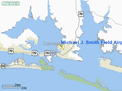
Michael J. Smith Field (ICAO: KMRH, FAA LID: MRH) is a public airport located one mile (2 km) north of the central business district of Beaufort and northeast of Morehead City, in Carteret County, North Carolina, United States. It is owned by the Beaufort-Morehead City Airport Authority.
The airport is named in memory of astronaut Michael J. Smith, a native of Beaufort who died in the Space Shuttle Challenger disaster. It was formerly known as Beaufort-Morehead City Airport.
Although most U.S. airports are assigned the same three-letter location identifier by the FAA and IATA, Michael J. Smith Field is assigned MRH by the FAA but has no designation from the IATA (which assigned MRH to May River Airport in Papua New Guinea).
Facilities and aircraft
Michael J. Smith Field covers an area of 400 acres (162 ha) which contains three asphalt paved runways: 3/21 measuring 4,191 x 150 ft. (1,277 x 46 m), 8/26 at 4,249 x 100 ft. (1,295 x 30 m), and 14/32 at 4,000 x 100 ft. (1,219 x 30 m).
For the 12-month period ending September 7, 2006, the airport had 43,800 aircraft operations, an average of 120 per day: 85% general aviation, 9% air taxi and 6% military. At that time there were 75 aircraft based at this airport: 93% single-engine and 7% multi-engine.
The above content comes from Wikipedia and is published under free licenses – click here to read more.
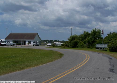 |
(Click on the photo to enlarge) |
Location & QuickFacts
| FAA Information Effective: | 2008-09-25 |
| Airport Identifier: | MRH |
| Airport Status: | Operational |
| Longitude/Latitude: | 076-39-38.1460W/34-44-00.7810N
-76.660596/34.733550 (Estimated) |
| Elevation: | 11 ft / 3.35 m (Surveyed) |
| Land: | 400 acres |
| From nearest city: | 1 nautical miles N of Beaufort, NC |
| Location: | Carteret County, NC |
| Magnetic Variation: | 08W (1985) |
Owner & Manager
| Ownership: | Publicly owned |
| Owner: | Beaufort-morehead Arpt Auth |
| Address: | Po Box 875
Beaufort, NC 28516 |
| Phone number: | 252-728-8470 |
| Manager: | John P Betts |
| Address: | P.o. Box 875
Beaufort, NC 28516 |
| Phone number: | 252-728-1928 |
Airport Operations and Facilities
| Airport Use: | Open to public |
| Wind indicator: | Yes |
| Segmented Circle: | No |
| Control Tower: | No |
| Lighting Schedule: | DUSK-DAWN
ACTVT MIRL RYS 03/21 & 08/26 , PAPI RYS 03 & 21, REIL RYS 03 & 21 - CTAF. |
| Beacon Color: | Clear-Green (lighted land airport) |
| Landing fee charge: | No |
| Sectional chart: | Charlotte |
| Region: | ASO - Southern |
| Boundary ARTCC: | ZDC - Washington |
| Tie-in FSS: | RDU - Raleigh |
| FSS on Airport: | No |
| FSS Toll Free: | 1-800-WX-BRIEF |
| NOTAMs Facility: | MRH (NOTAM-d service avaliable) |
| Federal Agreements: | NGPY3 |
Airport Communications
| CTAF: | 122.800 |
| Unicom: | 122.800 |
Airport Services
| Fuel available: | 100LLA1+ |
| Airframe Repair: | MAJOR |
| Power Plant Repair: | MAJOR |
| Bottled Oxygen: | NONE |
| Bulk Oxygen: | NONE |
Runway Information
Runway 03/21
| Dimension: | 4191 x 150 ft / 1277.4 x 45.7 m |
| Surface: | ASPH, Fair Condition |
| Weight Limit: | Single wheel: 12500 lbs. |
| Edge Lights: | Medium |
| |
Runway 03 |
Runway 21 |
| Longitude: | 076-39-42.8761W | 076-39-21.4247W |
| Latitude: | 34-43-38.8603N | 34-44-16.3408N |
| Elevation: | 6.00 ft | 6.00 ft |
| Alignment: | 25 | 127 |
| Traffic Pattern: | Left | Left |
| Markings: | Non-precision instrument, Good Condition | Non-precision instrument, Good Condition |
| Crossing Height: | 20.00 ft | 24.00 ft |
| Displaced threshold: | 186.00 ft | 0.00 ft |
| VASI: | 2-light PAPI on left side | 2-light PAPI on left side |
| Visual Glide Angle: | 3.00° | 3.00° |
| Runway End Identifier: | Yes | Yes |
| Obstruction: | 15 ft road, 299.0 ft from runway, 6:1 slope to clear
APCH RATIO 32:1 FM DSPLCD THLD. | 51 ft trees, 1092.0 ft from runway, 289 ft left of centerline, 17:1 slope to clear
RY 21 30 FT TREES 100 FT FROM THLD & 150 FT RIGHT. |
|
Runway 08/26
| Dimension: | 4249 x 100 ft / 1295.1 x 30.5 m |
| Surface: | ASPH, Good Condition |
| Weight Limit: | Dual wheel: 60000 lbs. |
| Edge Lights: | Medium |
| |
Runway 08 |
Runway 26 |
| Longitude: | 076-40-07.4971W | 076-39-20.2809W |
| Latitude: | 34-43-59.6347N | 34-44-15.3673N |
| Elevation: | 6.00 ft | 7.00 ft |
| Alignment: | 68 | 127 |
| ILS Type: | | LOCALIZER
|
| Traffic Pattern: | Left | Left |
| Markings: | Non-precision instrument, Poor Condition
RWY MARKINGS EXTREMELY FADED | Non-precision instrument, Poor Condition
RWY MARKINGS EXTREMELY FADED |
| Obstruction: | 23 ft tree, 270.0 ft from runway, 189 ft right of centerline, 3:1 slope to clear | 51 ft trees, 1229.0 ft from runway, 241 ft right of centerline, 20:1 slope to clear |
|
Runway 14/32
| Dimension: | 4001 x 100 ft / 1219.5 x 30.5 m |
| Surface: | ASPH, Good Condition |
| Weight Limit: | Single wheel: 12500 lbs. |
| |
Runway 14 |
Runway 32 |
| Longitude: | 076-39-55.8710W | 076-39-20.5442W |
| Latitude: | 34-44-10.2825N | 34-43-43.5242N |
| Elevation: | 6.00 ft | 9.00 ft |
| Alignment: | 127 | 127 |
| Traffic Pattern: | Left | Left |
| Markings: | Basic, Good Condition | Basic, Good Condition |
| Displaced threshold: | 0.00 ft | 490.00 ft |
| Obstruction: | 45 ft boat, 404.0 ft from runway, 4:1 slope to clear
+20 FT TREES 110 FT RIGHT; 0-200 FT FM THLD. | 56 ft trees, 290.0 ft from runway, 247 ft left of centerline, 1:1 slope to clear
APCH RATIO 22:1 FM DSPLCD THLD; 50 FT TREE 1100 FT FM DSPLCD THLD 0B. |
|
Radio Navigation Aids
| ID |
Type |
Name |
Ch |
Freq |
Var |
Dist |
| MRH | NDB | Morehead | | 269.00 | 08W | 0.2 nm |
| NCA | NDB | New River | | 356.00 | 08W | 38.0 nm |
| OUC | NDB/DME | Pamlico/dcmsnd | 034X | 404.00 | 09W | 40.4 nm |
| DIW | NDB/DME | Dixon | 107X | 198.00 | 08W | 40.4 nm |
| NKT | TACAN | Cherry Point | 075X | | 09W | 14.6 nm |
| NJM | TACAN | Bogue Mcalf | 067X | | 08W | 18.3 nm |
| NCA | TACAN | New River | 101X | | 08W | 38.6 nm |
| EWN | VOR/DME | New Bern | 083X | 113.60 | 08W | 27.9 nm |
Remarks
- NO LINE OF SIGHT BTWN RY ENDS.
- BIRDS ON & INVOF ARPT.
- NOISE ABATEMENT PROCEDURES IN EFFECT. RY 08/26 IS PREFERRED RY, WIND & SAFETY PERMITTING. AVOID OVERFLIGHT OF BEAUFORT WATERFRONT. CTC AMGR FOR FURTHER INFO 252-728-1928.
Images and information placed above are from
http://www.airport-data.com/airport/MRH/
We thank them for the data!
| General Info
|
| Country |
United States
|
| State |
NORTH CAROLINA
|
| FAA ID |
MRH
|
| Latitude |
34-44-00.781N
|
| Longitude |
076-39-38.146W
|
| Elevation |
11 feet
|
| Near City |
BEAUFORT
|
We don't guarantee the information is fresh and accurate. The data may
be wrong or outdated.
For more up-to-date information please refer to other sources.
|
|


