 |
|
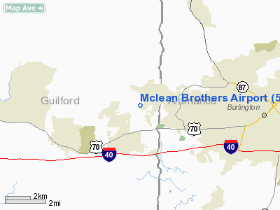
Location & QuickFacts
| FAA Information Effective: | 2008-09-25 |
| Airport Identifier: | 59NC |
| Airport Status: | Operational |
| Longitude/Latitude: | 079-33-19.0870W/36-05-50.4870N
-79.555302/36.097358 (Estimated) |
| Elevation: | 696 ft / 212.14 m (Surveyed) |
| Land: | 150 acres |
| From nearest city: | 1 nautical miles SW of Gibsonville, NC |
| Location: | Guilford County, NC |
| Magnetic Variation: | 06W (1985) |
Owner & Manager
| Ownership: | Privately owned |
| Owner: | Charles E. Moore |
| Address: | 120 Nc Hwy 100
Gibsonville, NC 27249 |
| Phone number: | 336-449-7346 |
| Manager: | Charles E. Moore |
| Address: | 120 Nc Hwy 100
Gibsonville, NC 27249 |
| Phone number: | 336-214-6367 |
Airport Operations and Facilities
| Airport Use: | Private |
| Wind indicator: | Yes |
| Segmented Circle: | No |
| Control Tower: | No |
| Landing fee charge: | No |
| Sectional chart: | Charlotte
ALSO CHARTED ON CHARLOTTE SECTIONAL AERONAUTICAL CHART. |
| Region: | ASO - Southern |
| Traffic Pattern Alt: | 800 ft |
| Boundary ARTCC: | ZDC - Washington |
| Tie-in FSS: | RDU - Raleigh |
| FSS on Airport: | No |
| FSS Toll Free: | 1-800-WX-BRIEF |
Airport Communications
Airport Services
| Airframe Repair: | MAJOR |
| Power Plant Repair: | MAJOR |
| Bottled Oxygen: | NONE |
| Bulk Oxygen: | NONE |
Runway Information
Runway 06/24
| Dimension: | 2200 x 170 ft / 670.6 x 51.8 m |
| Surface: | TURF, Good Condition |
| |
Runway 06 |
Runway 24 |
| Traffic Pattern: | Left | Left |
| Markings: | None, | None, |
| Runway End Identifier: | No | No |
| Centerline Lights: | No | No |
| Touchdown Lights: | No | No |
| Obstruction: | 45 ft trees, 90 ft left of centerline | 40 ft trees, 0.0 ft from runway, 60L/ ft right of centerline |
|
Radio Navigation Aids
| ID |
Type |
Name |
Ch |
Freq |
Var |
Dist |
| OQA | FAN MARKER | Rockingham County | | | | 23.8 nm |
| HB | NDB | Himun | | 361.00 | 08W | 7.3 nm |
| SIF | NDB | Slammer | | 423.00 | 07W | 19.9 nm |
| TOX | NDB | Siler City | | 371.00 | 07W | 20.7 nm |
| HUR | NDB | Person | | 220.00 | 08W | 25.1 nm |
| CQJ | NDB | City Lake | | 266.00 | 08W | 27.4 nm |
| UV | NDB | Bales | | 396.00 | 07W | 34.4 nm |
| SEN | NDB | Swearing/dcmsnd | | 260.00 | 06W | 40.9 nm |
| TT | NDB | Leeco | | 406.00 | 08W | 41.4 nm |
| LE | NDB | Leevy | | 350.00 | 07W | 41.8 nm |
| VU | NDB | Aller | | 346.00 | 06W | 44.7 nm |
| DVZ | NDB | Davie | | 354.00 | 06W | 45.2 nm |
| EEJ | NDB | Lee County/dcmsnd | | 428.00 | 07W | 46.4 nm |
| HXO | NDB | Huntsboro | | 271.00 | 07W | 47.0 nm |
| DAN | VOR | Danville | | 113.10 | 06W | 30.3 nm |
| LIB | VORTAC | Liberty | 077X | 113.00 | 03W | 17.4 nm |
| GSO | VORTAC | Greensboro | 109X | 116.20 | 03W | 20.7 nm |
| RDU | VORTAC | Raleigh/durham | 119X | 117.20 | 04W | 39.9 nm |
| SBV | VORTAC | South Boston | 041X | 110.40 | 05W | 43.5 nm |
Remarks
- BEGAN OPERATIONS - 1934.
- BEGAN OPERNS 1934.
Images and information placed above are from
http://www.airport-data.com/airport/59NC/
We thank them for the data!
| General Info
|
| Country |
United States
|
| State |
NORTH CAROLINA
|
| FAA ID |
59NC
|
| Latitude |
36-05-50.487N
|
| Longitude |
079-33-19.087W
|
| Elevation |
696 feet
|
| Near City |
GIBSONVILLE
|
We don't guarantee the information is fresh and accurate. The data may
be wrong or outdated.
For more up-to-date information please refer to other sources.
|
|


